- Australia ▾
- Topographic
▾
- Australia AUSTopo 250k (2024)
- Australia 50k Geoscience maps
- Australia 100k Geoscience maps
- Australia 250k Geoscience maps
- Australia 1.1m Geoscience maps
- New Zealand 50k maps
- New Zealand 250k maps
- New South Wales 25k maps
- New South Wales 50k maps
- New South Wales 100k maps
- Queensland 10k maps
- Queensland 25k maps
- Queensland 50k maps
- Queensland 100k maps
- Compasses
- Software
- GPS Systems
- Orienteering
- International ▾
- Wall Maps
▾
- World
- Australia & New Zealand
- Countries, Continents & Regions
- Historical
- Vintage National Geographic
- Australian Capital Territory
- New South Wales
- Northern Territory
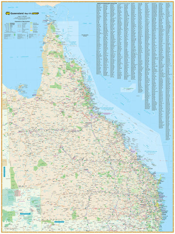
- Queensland
- South Australia
- Tasmania
- Victoria
- Western Australia
- Celestial
- Children's
- Mining & Resources
- Wine Maps
- Healthcare
- Postcode Maps
- Electoral Maps
- Nautical ▾
- Flags
▾
- Australian Flag Sets & Banners
- Flag Bunting
- Handwavers
- Australian National Flags
- Aboriginal Flags
- Torres Strait Islander Flags
- International Flags
- Flagpoles & Accessories
- Australian Capital Territory Flags
- New South Wales Flags
- Northern Territory Flags
- Queensland Flags
- South Australia Flags
- Tasmania Flags
- Victoria Flags
- Western Australia Flags
- Gifts ▾
- Globes ▾
Dear valued customer. Please note that our checkout is not supported by old browsers. Please use a recent browser to access all checkout capabilities


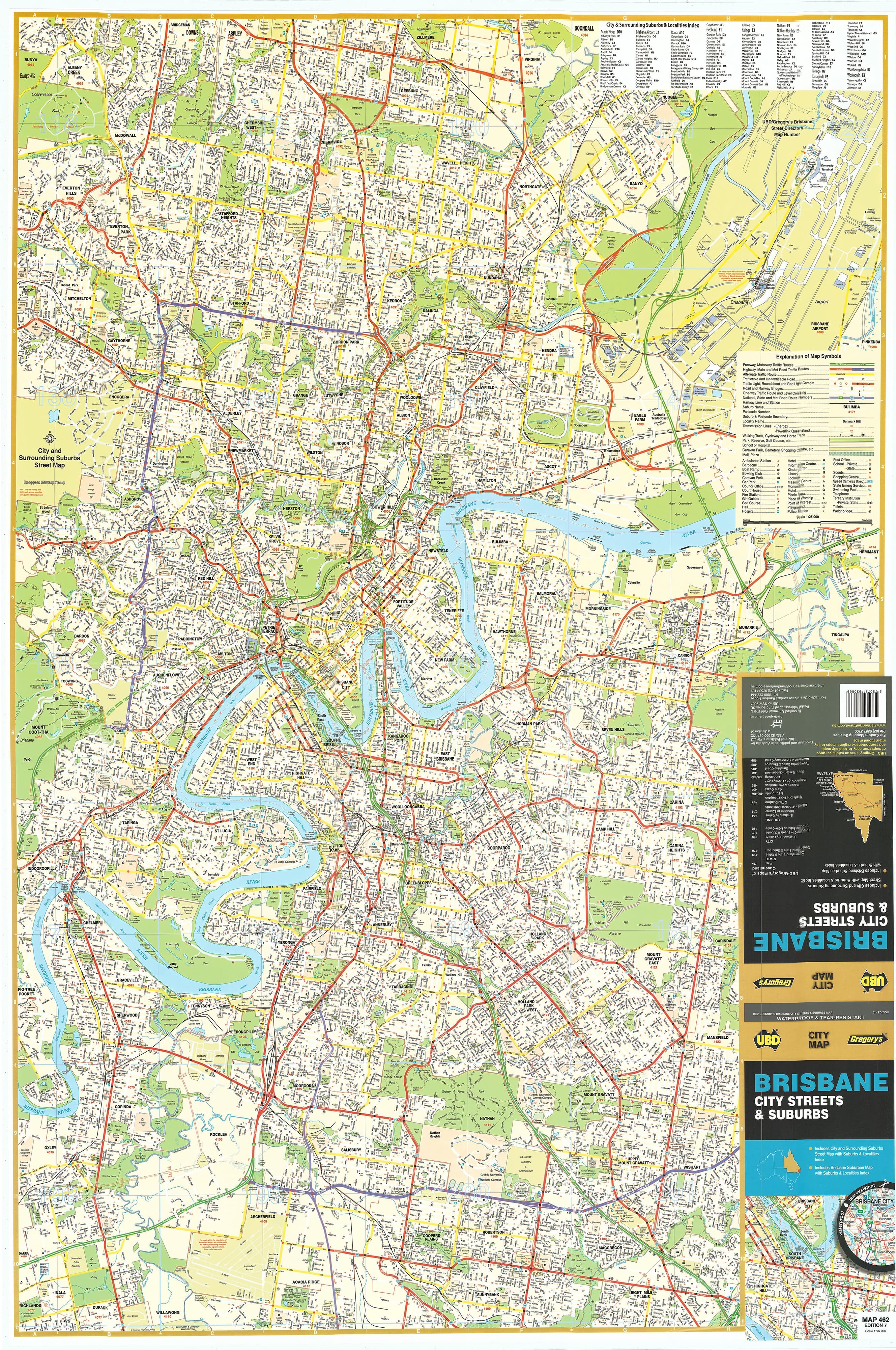
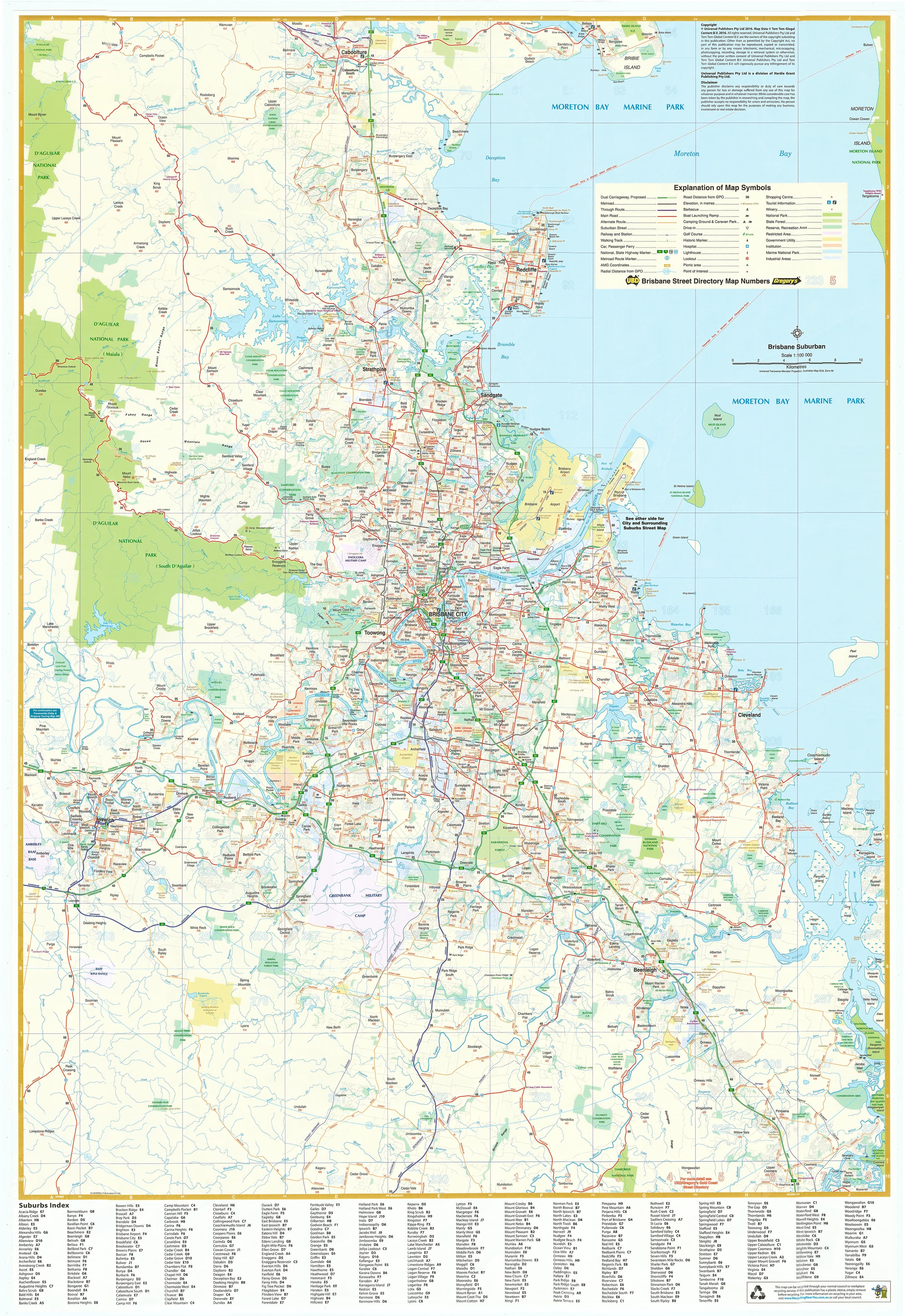
Brisbane City Streets & Suburbs UBD 462 Map
$13.95
Afterpay is only available for orders between $50.00 and $1000.00 More info
A comprehensive, easy-to-read map of Brisbane’s inner city and greater suburban area — ideal for offices, planning spaces, classrooms, and homes
Whether you're buying a home, mapping out a delivery area, managing city infrastructure, or just trying to understand Brisbane’s layout, this 2024 double-sided wall map by UBD Gregory’s delivers exceptional detail, clarity, and practical usability. Featuring both a street-level map of the inner city and a broad suburban overview, it provides a complete perspective of Australia’s third-largest city — from high-density urban precincts to sprawling suburban developments.
Printed in full colour with accurate cartographic detail, this map is available in both laminated and folded formats to suit your needs.
🗺️ SIDE A: Central Brisbane City Map
Scale: 1:25,000
This side presents a high-resolution street-level map of Brisbane’s inner and middle suburbs — perfect for real estate research, urban planning, and service area navigation. It covers a wide swathe of the city’s most active zones, including:
-
Northwest: McDowall
-
Northeast: Nudgee
-
Southwest: Willawong
-
Southeast: Eight Mile Plains
All roads, laneways, parks, rivers, and key infrastructure are clearly marked. Local landmarks, arterial corridors, commercial hubs, and schools are shown, making this an essential planning tool for professionals and residents alike.
🏙️ SIDE B: Greater Brisbane Suburban Map
Scale: 1:100,000
On the reverse, a large-scale map shows Brisbane's full 75 km suburban radius, offering a bird's-eye view of the entire metro region. Coverage extends:
-
North to Caboolture
-
South to Coomera
-
West to Ipswich
-
Includes Redcliffe Peninsula, Logan, Moreton Bay, and parts of the Scenic Rim
Key features include:
-
Main roads and highways, such as the Bruce Highway, Pacific Motorway, Gateway Motorway, and Logan Motorway
-
Railway lines, industrial zones, national parks, and coastal boundaries
-
Clearly defined suburb outlines, each marked with postcode numbers
-
A fully indexed list of suburbs, cross-referenced by postcode for quick look-up
🖨️ PRINT & LAMINATION QUALITY
This map is printed on high-quality stock and is available in two laminated formats:
-
Flat Laminated – $99.00
-
Supplied flat, ready to pin, mount, or frame
-
Perfect for offices, schools, council chambers, or formal display
-
-
Laminated Folded – $45.00
-
A previously folded map, laminated for durability
-
Ideal for casual or mobile use — may have visible crease lines but is still water-resistant and long-lasting
-
Both laminated versions are:
-
Encapsulated in gloss laminate, making them:
-
Tear-resistant and waterproof
-
Wipeable with whiteboard markers
-
Compatible with Map Dots for plotting key locations
-
A folded paper-only version is also available for on-the-go use.
📐 MAP SPECIFICATIONS
-
Published: 2024
-
Scales:
-
Central Brisbane: 1:25,000
-
Greater Brisbane: 1:100,000
-
-
Size: 700 mm wide × 1000 mm high
-
Orientation: Portrait
-
Format: Double-sided, full-colour
-
Publisher: UBD Gregory’s
-
Printed in: Australia
🎯 PERFECT FOR:
-
Real estate professionals needing postcode and suburb clarity
-
Delivery companies and logistics teams planning urban and suburban coverage
-
Urban planners, architects, and builders
-
Teachers and students using Brisbane as a case study in geography or civics
-
Relocating families and new residents wanting to explore their city
-
Home offices, shared workspaces, and council departments
✅ WHY CHOOSE THIS MAP?
-
Produced by UBD Gregory’s, Australia’s most trusted mapping publisher
-
Updated for 2024, reflecting the latest urban developments and road upgrades
-
Combines fine-grain detail and macro suburban context in one neat product
-
Offers aesthetics and function, with clear labels, legible fonts, and vibrant colour coding
-
Designed to be used — not just displayed
Explore Brisbane with confidence.
Whether you're pinpointing schools, planning a move, defining service zones, or simply decorating your workspace with a practical reference — the Brisbane City & Suburbs Wall Map by UBD Gregory’s is your clear and comprehensive guide to this dynamic Australian capital.
Reliable. Durable. Beautiful. Mapped for modern Brisbane.