- Australia ▾
- Topographic
▾
- Australia AUSTopo 250k (2025)
- Australia 50k Geoscience maps
- Australia 100k Geoscience maps
- Australia 250k Geoscience maps
- Australia 1:1m Geoscience maps
- New Zealand 50k maps
- New Zealand 250k maps
- New South Wales 25k maps
- New South Wales 50k maps
- New South Wales 100k maps
- Queensland 10k maps
- Queensland 25k maps
- Queensland 50k maps
- Queensland 100k maps
- Compasses
- Software
- GPS Systems
- Orienteering
- International ▾
- Wall Maps
▾
- World
- Australia & New Zealand
- Countries, Continents & Regions
- Historical
- Vintage National Geographic
- Australian Capital Territory
- New South Wales
- Northern Territory
- Queensland
- South Australia
- Tasmania
- Victoria
- Western Australia
- Celestial
- Children's
- Mining & Resources
- Wine Maps
- Healthcare
- Postcode Maps
- Electoral Maps
- Nautical ▾
- Flags
▾
- Australian Flag Sets & Banners
- Flag Bunting
- Handwavers
- Australian National Flags
- Aboriginal Flags
- Torres Strait Islander Flags
- International Flags
- Flagpoles & Accessories
- Australian Capital Territory Flags
- New South Wales Flags
- Northern Territory Flags
- Queensland Flags
- South Australia Flags
- Tasmania Flags
- Victoria Flags
- Western Australia Flags
- Gifts ▾
- Globes ▾
Dear valued customer. Please note that our checkout is not supported by old browsers. Please use a recent browser to access all checkout capabilities
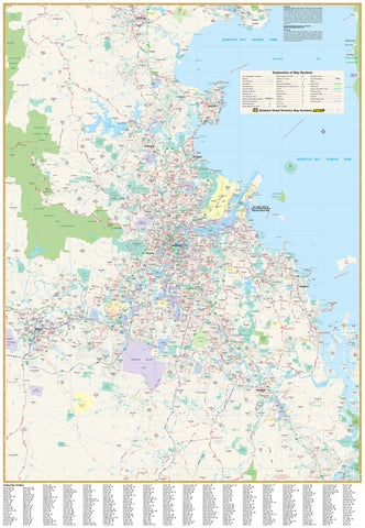
Brisbane & Region Hema 700 x 1000mm Paper Map Wall Map
$89.95
or make 4 interest-free payments of
$22.49 AUD
fortnightly with
![]() More info
More info
Brisbane & Region — Hema Wall Map
Paper • FSC 170 gsm • HP Archival Pigment Inks (Fade-Resistant)
See Greater Brisbane at a glance. This Hema wall map spans Bribie Island (north) to Jimboomba (south) and west to Ipswich, balancing clean cartography with practical detail at 1:70,000 scale. Ideal for planning, logistics, teaching, or everyday reference in home and office spaces.
📍 Map Coverage
-
North–South: Bribie Island → Jimboomba
-
West–East: Ipswich → Brisbane’s bayside corridor
-
Captures key suburban corridors, growth areas, and arterial connections across the metro region.
🗺️ What’s Shown (At a Glance)
-
Road network: Major & secondary roads, Metroads
-
Route numbers: State & national route designations
-
Freeways: Present alignments plus planned corridors (where available)
-
Postcodes: Clearly annotated for territory mapping and service planning
-
Suburb index: Alphabetical index for fast lookups
🗝️ Key Benefits
-
Business-ready: Postcodes + suburb index streamline delivery, sales, and service zones
-
High legibility: Hema’s uncluttered design reads clearly from meeting-room distance
-
Planning clarity: Route hierarchies and motorway structures are easy to follow
-
Frame-friendly: Matte stock minimises glare under glass for crystal-clear viewing
🎨 Materials & Finish
-
FSC-Certified 170 gsm Matte Paper (Sustainable)
Premium, responsibly sourced stock with a smooth, glare-free surface — perfect for framing under glass while preserving fine linework and subtle colour transitions. -
Hewlett-Packard Archival Pigment Inks (Fade-Resistant)
Museum-grade pigments deliver crisp detail and colour stability designed to resist fading over time, so your map stays vibrant and readable for years.
Want a wipe-clean or gallery presentation? Ask about matching Laminated, Laminated + Hang Rails, Canvas, or Canvas + Hang Rails versions.
📐 Size & Scale
-
Print Size: 700 mm (W) × 1000 mm (H)
-
Scale: 1:70,000
-
Orientation: Portrait
📊 Specifications
| Attribute | Details |
|---|---|
| Title | Brisbane & Region Hema Wall Map |
| Scale | 1:70,000 |
| Coverage | Bribie Island (N) to Jimboomba (S); west to Ipswich |
| Features | Major & secondary roads, Metroads, state/national routes, current & planned freeways, postcodes, suburb index |
| Format | Paper (FSC-certified 170 gsm matte) |
| Inks | HP archival pigment inks (fade-resistant) |
| Print Size | 700 × 1000 mm |
🎯 Ideal Uses
-
Business & logistics: Territory planning, postcode allocations, service footprints
-
Sales & marketing: Visualise catchments and travel times quickly
-
Education: Geography, urban studies, transport networks
-
Home & office décor: A functional, attractive Brisbane reference
🖼️ Framing Tips
-
Choose non-reflective (museum) glass to keep the matte paper glare-free
-
A slim, neutral frame keeps focus on the map detail
-
If matting, cut the window 2–3 mm undersize for a snug, professional fit
🌱 Sustainability & Quality
-
FSC-Certified Paper: Supports responsible forestry and lower-impact sourcing
-
Archival Pigments: HP inks help prevent fading, protecting your investment
-
Colour-Managed Print: Consistent tones and razor-sharp type across the sheet
🛒 Order your Brisbane & Region — Hema Paper Wall Map today — printed on FSC 170 gsm paper with HP archival pigment inks for crisp, long-lasting, fade-resistant colour.


