- Australia ▾
- Topographic
▾
- Australia AUSTopo 250k (2025)
- Australia 50k Geoscience maps
- Australia 100k Geoscience maps
- Australia 250k Geoscience maps
- Australia 1:1m Geoscience maps
- New Zealand 50k maps
- New Zealand 250k maps
- New South Wales 25k maps
- New South Wales 50k maps
- New South Wales 100k maps
- Queensland 10k maps
- Queensland 25k maps
- Queensland 50k maps
- Queensland 100k maps
- Compasses
- Software
- GPS Systems
- Orienteering
- International ▾
- Wall Maps
▾
- World
- Australia & New Zealand
- Countries, Continents & Regions
- Historical
- Vintage National Geographic
- Australian Capital Territory
- New South Wales
- Northern Territory
- Queensland
- South Australia
- Tasmania
- Victoria
- Western Australia
- Celestial
- Children's
- Mining & Resources
- Wine Maps
- Healthcare
- Postcode Maps
- Electoral Maps
- Nautical ▾
- Flags
▾
- Australian Flag Sets & Banners
- Flag Bunting
- Handwavers
- Australian National Flags
- Aboriginal Flags
- Torres Strait Islander Flags
- International Flags
- Flagpoles & Accessories
- Australian Capital Territory Flags
- New South Wales Flags
- Northern Territory Flags
- Queensland Flags
- South Australia Flags
- Tasmania Flags
- Victoria Flags
- Western Australia Flags
- Gifts ▾
- Globes ▾
Dear valued customer. Please note that our checkout is not supported by old browsers. Please use a recent browser to access all checkout capabilities
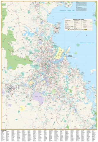
Brisbane & Region Hema 700 x 1000mm Laminated Wall Map with Hang Rails
$225.00
or make 4 interest-free payments of
$56.25 AUD
fortnightly with
![]() More info
More info
Brisbane & Region — Hema Wall Map
Laminated (True Encapsulation) • Timber Hang Rails • Ready to Hang
See Greater Brisbane in crisp detail. This Hema wall map spans Bribie Island (north) to Jimboomba (south) and west to Ipswich, balancing clean cartography with practical information at 1:70,000 scale. It’s ideal for planning, logistics, teaching, and everyday reference—now supplied laminated with timber hang rails for a durable, display-ready finish.
📍 Map Coverage
-
North–South: Bribie Island → Jimboomba
-
West–East: Ipswich → Brisbane’s bayside corridor
-
Captures key suburban corridors, growth areas, and arterial connections across the metro region.
🗺️ What’s Shown (At a Glance)
-
Road network: Major & secondary roads, Metroads
-
Route numbers: State & national route designations
-
Freeways: Present alignments plus planned corridors (where available)
-
Postcodes: Clearly annotated for territory mapping and service planning
🗝️ Key Benefits
-
Business-ready: Postcodes streamline delivery, sales, and service zones
-
High legibility: Hema’s uncluttered design reads clearly from meeting-room distance
-
Planning clarity: Route hierarchies and motorway structures are easy to follow
-
Display-ready: Arrives laminated with hang rails—no framing required
🎨 Materials & Finish
💧 Lamination (True Encapsulation)
-
Encased in 2 × 80-micron gloss films, fully edge-sealed
-
Waterproof, tear-resistant, wipe-clean surface
-
Use whiteboard markers and Mark-It-Dots—erase cleanly without damage
🪵 Timber Hang Rails
-
Natural timber rails (lacquered) fitted top & bottom
-
Strong top hanging cord for quick, tidy wall mounting (single hook friendly)
-
Warm, professional presentation suited to offices, classrooms, and home study spaces
🖨️ Print Quality
-
Printed in Australia with pigment-based, fade-resistant inks for crisp linework and stable colour
⚠️ Lead time: Hang rails are custom-fitted—please allow up to 10 working days for delivery.
📐 Size & Scale
-
Print size: 700 mm (W) × 1000 mm (H)
-
Scale: 1:70,000
-
Orientation: Portrait
🧽 Care & Use
-
Write with non-permanent whiteboard markers; wipe clean with a soft, dry cloth
-
For dots/labels, use Map/Mark-It-Dots to avoid residue
-
Avoid ammonia/alcohol cleaners; a damp microfiber cloth is best for stubborn marks
📊 Specifications
| Attribute | Details |
|---|---|
| Title | Brisbane & Region Hema Wall Map |
| Scale | 1:70,000 |
| Coverage | Bribie Island (N) to Jimboomba (S); west to Ipswich |
| Features | Major & secondary roads, Metroads, state/national routes, current & planned freeways, postcodes |
| Format | Laminated + Timber Hang Rails |
| Laminate | 2 × 80-micron gloss (true encapsulation) |
| Hang Rails | Natural timber, lacquered; top hanging cord |
| Inks | Pigment-based, fade-resistant |
| Origin | Printed in Australia |
🎯 Ideal Uses
-
Businesses & offices: Territory planning, postcode reference, wall-ready display
-
Logistics & service teams: Route planning across metro Brisbane
-
Schools & libraries: Durable, easy-to-read teaching and display map
-
Households: A practical Brisbane reference that looks great on the wall
🛒 Order your Brisbane & Region — Hema Laminated Wall Map with Hang Rails today—durable, wipe-clean, and ready to hang for daily use.


