

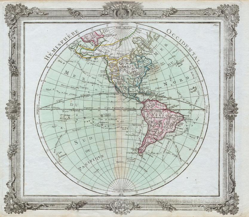
Coasts, Colonies & Trade — Brion de la Tour: Western Hemisphere Wall Map (1764)
A mid-eighteenth-century view of the Atlantic world, rendered with clarity and restraint. Created by Louis Brion de la Tour in 1764—titled Hémisphere Occidental—this hemispheric sheet brings North and South America, the Atlantic & Pacific coasts, and adjoining islands into sharp focus. Continental outlines, colonial-era boundaries, principal towns and ports, and rivers and coastlines are set out in clean, legible cartography that rewards both room-distance viewing and close study. It’s the fabric of the Western Hemisphere—explored, contested, and unmistakably of its era—made to study, admire, and display.
More Than a Map – A Testament to History
This isn’t just wall art—it’s a reference frame for how empires traded, sailed, and drew borders in the 1760s. Every coastline, label, and boundary captures the geopolitics and navigation of the age. Ideal for educators, genealogists, historians, designers, and collectors, this sheet stands alone beautifully and pairs powerfully with modern political maps for then-and-now comparisons.
Hang it in libraries, studios, classrooms, museums, offices, or at home to invite reflection, study, and conversation.
Premium Materials & Finishes
We treat history with the respect it deserves. That’s why we offer multiple formats, each produced using high-quality materials and modern archival printing.
🌟 Archival Paper Print
Printed on heavyweight 160gsm archival-grade paper.
Smooth matte finish reduces glare and preserves fine linework and small labels.
Ideal for framing under glass—clean, timeless, and built to last.
💎 Laminated Edition
Encapsulated in two sheets of 80-micron gloss laminate using true thermal bonding—not just surface lamination.
Moisture-resistant, wipe-clean surface with UV-filtering laminate to help reduce fading over time.
Optional Natural Timber Hang Rails: lacquered rails with a fitted hanging cord provide a polished, ready-to-hang presentation—no frame required. (Please allow up to 10 working days for delivery with hang rails.)
🏆 Museum-Quality Canvas
Printed on heavyweight 395gsm HP Professional Matte Canvas for rich texture and exceptional strength.
Pigment-based, fade-resistant inks deliver deep tone and crisp typography that endure for generations.
Optional Natural Timber Hang Rails: lacquered to enhance the wood grain and protect against wear; top cord for effortless hanging—elegant in any setting. (Please allow up to 10 working days for delivery with hang rails.)
Specifications
| Feature | Details |
|---|---|
| Title | Brion de la Tour: Western Hemisphere Wall Map |
| French Title | Hémisphere Occidental |
| Original Publication | 1764 |
| Cartographer | Louis Brion de la Tour |
| Scale | Not specified |
| Cartographic Content | Continental outlines; colonial-era borders; principal towns/ports; rivers; coastlines |
| Map Size | 1000 mm (W) × 870 mm (H) |
| Available Formats | Paper, Laminated, Canvas |
| Paper Weight | 160gsm archival-quality |
| Laminate | 2 × 80-micron gloss laminate sheets (encapsulated; UV-filtering) |
| Canvas Weight | 395gsm HP Professional Matte Canvas |
| Inks | Pigment-based, fade-resistant |
| Optional Hang Rails | Available on Laminated & Canvas (lead time up to 10 working days) |
| Origin | Made in Australia |
Why Choose This Map
✔ Era-True Snapshot: The Western Hemisphere as charted in 1764 at the height of the imperial age.
✔ Genealogy-Ready: Dense place-naming aids family-history and academic research.
✔ Clarity at Scale: Elegant engraving and tidy symbology read beautifully across a room and up close.
✔ Decorative & Scholarly: Striking wall presence with genuine reference value.
✔ Archival Craft: Premium substrates and inks preserve contrast, labels, and linework for decades.
Our Commitment
We believe that preserving history is as important as telling it. Every map is printed locally in Australia using state-of-the-art technology, carefully checked by hand, and packed with care. From the moment it leaves our workshop to the day it hangs on your wall, we ensure quality you can trust and a legacy you’ll be proud to share.
Place the eighteenth-century Atlantic world in your space. Order the Brion de la Tour: Western Hemisphere Wall Map (1764) today—a faithful, beautifully produced sheet that turns a room into a conversation.


