- Australia ▾
- Topographic
▾
- Australia AUSTopo 250k (2025)
- Australia 50k Geoscience maps
- Australia 100k Geoscience maps
- Australia 250k Geoscience maps
- Australia 1:1m Geoscience maps
- New Zealand 50k maps
- New Zealand 250k maps
- New South Wales 25k maps
- New South Wales 50k maps
- New South Wales 100k maps
- Queensland 10k maps
- Queensland 25k maps
- Queensland 50k maps
- Queensland 100k maps
- Western Australia 25k maps
- Western Australia 50k maps
- Western Australia 100k maps
- Compasses
- Software
- GPS Systems
- International ▾
- Wall Maps
▾
- World
- Australia & New Zealand
- Countries, Continents & Regions
- Historical
- Vintage National Geographic
- Australian Capital Territory
- New South Wales
- Northern Territory
- Queensland
- South Australia
- Tasmania
- Victoria
- Western Australia
- Celestial
- Children's
- Mining & Resources
- Wine Maps
- Healthcare
- Postcode Maps
- Electoral Maps
- Nautical ▾
- Flags
▾
- Australian Flag Sets & Banners
- Flag Bunting
- Handwavers
- Australian National Flags
- Aboriginal Flags
- Torres Strait Islander Flags
- International Flags
- Flagpoles & Accessories
- Australian Capital Territory Flags
- New South Wales Flags
- Northern Territory Flags
- Queensland Flags
- South Australia Flags
- Tasmania Flags
- Victoria Flags
- Western Australia Flags
- Gifts ▾
- Globes ▾
Dear valued customer. Please note that our checkout is not supported by old browsers. Please use a recent browser to access all checkout capabilities


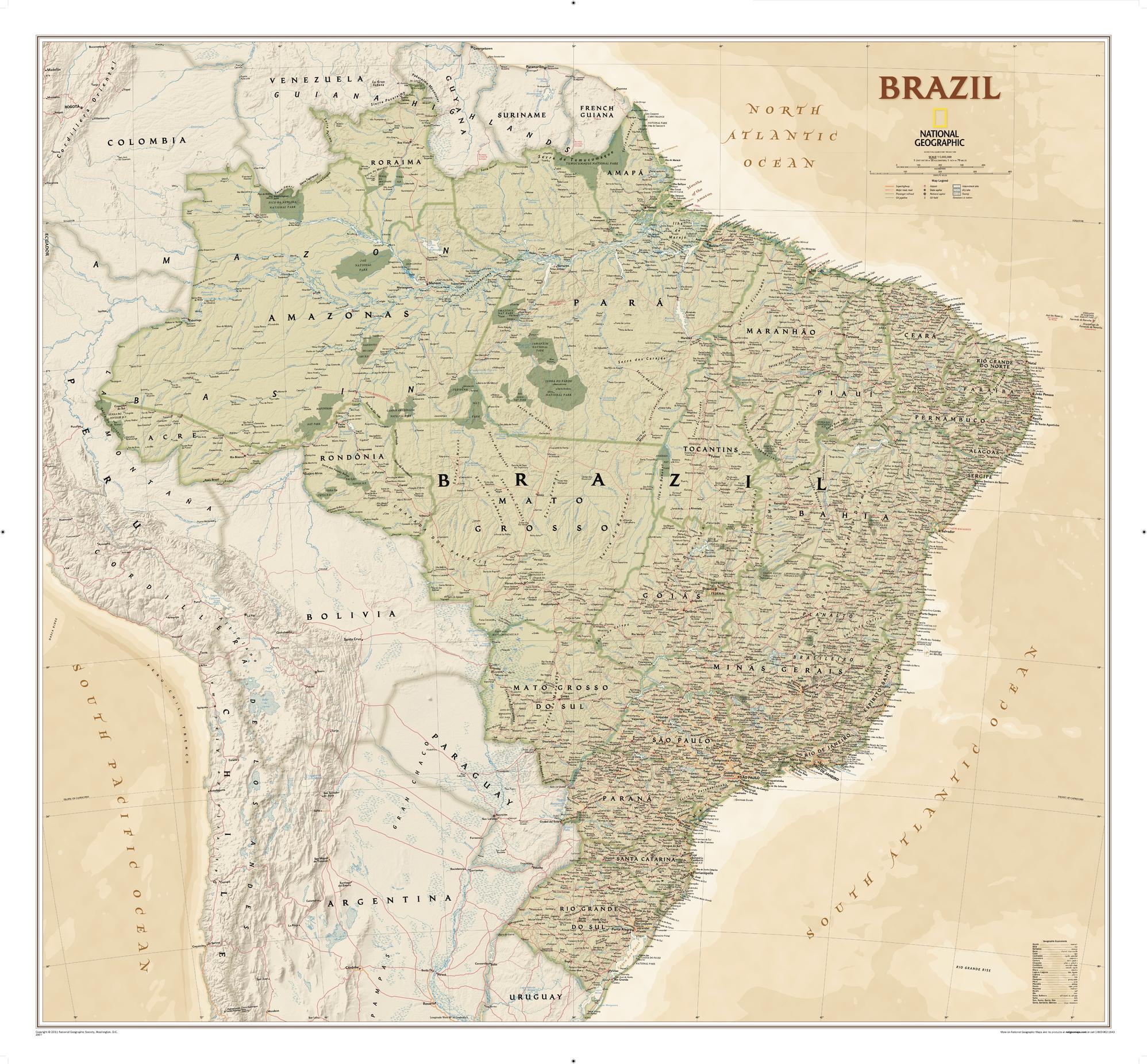
Brazil Executive National Geographic 1040 x 965mm Wall Map
$79.95
or make 4 interest-free payments of
$19.99 AUD
fortnightly with
![]() More info
More info
1040 x 965mm | Stunning Detail | Premium Presentation
National Geographic's Brazil Executive Wall Map is a grand representation of Brazil – the largest country in South America and the fifth-largest in the world. This map offers an unmatched level of detail, covering the entire country, including its 26 states, one federal district, and the coastal islands such as Fernando de Noronha National Marine Park and Abrolhos National Park. Whether you're a geography enthusiast, educator, or business professional, this map is an indispensable tool for understanding Brazil’s vast geographical diversity.
🗺️ Features & Highlights of the Brazil Executive Wall Map
🌍 Comprehensive Coverage of Brazil
-
States & Federal Districts: Features all 26 states and one federal district. State capitals and key cities are clearly labelled, providing a thorough overview of Brazil’s political structure.
-
Coastal Islands & Protected Areas: The map highlights Fernando de Noronha, Abrolhos National Park, and the Arquipélago dos Abrolhos—giving special attention to Brazil's marine ecosystems.
-
Rivers and Waterways: Brazil's extensive river network, which feeds into the Amazon River, is meticulously mapped. The Amazon River, the second-longest river in the world, is prominently displayed.
-
National Parks: Major national parks are highlighted, including the Pantanal, the world’s largest tropical wetland, and Iguaçu National Park, home to the famous Iguaçu Falls.
🌍 Geographical Features
-
Mountain Ranges: The Andes mountains to the west and the Brazilian Highlands to the east are shown in shaded relief, providing a topographic view of the land.
-
Coastal Regions: The map vividly depicts the coastlines along the Atlantic Ocean, illustrating key features like beaches, islands, and protected marine areas.
-
Rivers and Wetlands: Rivers, wetlands, and natural reserves like Iguaçu Falls, Pantanal, and Amazonian Rainforest are clearly marked to showcase Brazil's biodiversity.
🏙️ Urban & Cultural Landmarks
-
Major Cities: The country’s capital, Brasília, and prominent cities such as Rio de Janeiro, São Paulo, and Manaus are highlighted, with clear labels and notable landmarks.
-
Transportation Infrastructure: The map also includes highways, railroads, airports, and other infrastructure networks, helping users understand Brazil’s connectivity.
-
Cultural & Historical Points of Interest: Brazil’s diverse cultural regions are reflected in historical sites, famous landmarks, and natural wonders like the Christ the Redeemer statue in Rio de Janeiro and the Amazon Rainforest.
🖼️ Finishing Options to Suit Your Space
Choose from several high-quality finishes to display this beautiful map in your home or office:
| Format | Description |
|---|---|
| 📜 Paper (160 gsm) | Printed on premium matte-coated paper—perfect for framing under glass. |
| 🧼 Laminated (Encapsulated) | 80-micron gloss laminate offers durability and easy cleaning for high-traffic areas. |
| 🪵 Laminated with Wooden Hang Rails | Laminated version mounted with natural timber rails for easy hanging. Ready to display. |
| 🖼️ Canvas (395 gsm) | HP Professional Matte Canvas printed with pigment-based inks. This option provides an artistic and archival-quality finish. |
| 🪵 Canvas with Wooden Hang Rails | Canvas mounted with lacquered timber rails—no framing required. This option brings a sophisticated and elegant look. |
🔨 Note: Please allow 10 working days for delivery of hang-railed maps, as each one is professionally mounted by our framer.
📐 Specifications
| Feature | Detail |
|---|---|
| Title | Brazil Executive National Geographic Wall Map |
| Map Type | Political / Physical |
| Scale | 1:5,000,000 |
| Dimensions | 1040 mm (W) x 965 mm (H) |
| Material Options | Paper, Laminated, Canvas, With or Without Timber Rails |
| Printed & Mounted In | Australia |
🎁 Perfect For...
-
🌍 Geography Enthusiasts: Ideal for cartography lovers, Brazil enthusiasts, or those with a passion for South American geography.
-
🌍 Educators & Students: A fantastic teaching tool for students and teachers studying Brazil’s physical geography or South American studies.
-
🌍 Travel & Nature Lovers: A great map for those who are exploring or want to learn more about Brazil’s natural beauty, from rainforests to rivers and mountains.
-
🌍 Interior Designers: A statement piece for living rooms, offices, libraries, and studies, offering a bold and educational look.
🚚 Delivery & Framing Notes
-
Paper, Laminated, and Canvas (rolled) maps: Ships within 1–2 business days.
-
Hang-railed maps: Made to order—please allow up to 10 working days for production.
-
Secure Packaging: All maps are carefully packaged in protective materials to ensure they arrive in perfect condition.
🌍 Explore the Wonders of Brazil
The Brazil Executive National Geographic Wall Map is not just a map; it's a journey into Brazil’s diverse geography, from the Amazon Rainforest to the Pantanal wetlands and beyond. Whether you're studying the landforms, rivers, or cities, this map provides an incredible visual experience.
👉 Order yours today and immerse yourself in the landscape and cultural wonders of Brazil!
Frequently Asked Questions
What are the dimensions of the Brazil Executive National Geographic 1040 x 965mm Wall Map?
Mapworld wall maps range from standard 700×1000mm to large-format 1000×1430mm Supermaps. The exact dimensions for this map are shown in the product title. Where multiple sizes are available, select your preferred size when adding to cart.
Is this wall map available laminated?
Many Mapworld wall maps are available in paper, laminated, or framed finishes. Check the product options when adding to cart. Laminated maps are wipe-clean and more durable.
Is this the latest edition?
Mapworld stocks the most current editions available from all publishers. Edition year is shown in the product title where applicable. Mapworld updates its catalogue as new editions are released.
Can I write on or pin this wall map?
Laminated wall maps can be written on with whiteboard markers and wiped clean. Paper maps can be pinned on a corkboard. Choose a laminated option for a writeable surface.
Does Mapworld ship the Brazil Executive National Geographic 1040 x 965mm Wall Map across Australia?
Yes, Mapworld ships Australia-wide. Standard shipping is a flat $7 rate, with free standard shipping on orders over $75. Express options are available at checkout. Most orders placed before 2pm AEST on weekdays are dispatched same day.
Related Items


© 2026 Mapworld. Website designed by Genie Media
X