- Australia ▾
- Topographic
▾
- Australia AUSTopo 250k (2025)
- Australia 50k Geoscience maps
- Australia 100k Geoscience maps
- Australia 250k Geoscience maps
- Australia 1:1m Geoscience maps
- New Zealand 50k maps
- New Zealand 250k maps
- New South Wales 25k maps
- New South Wales 50k maps
- New South Wales 100k maps
- Queensland 10k maps
- Queensland 25k maps
- Queensland 50k maps
- Queensland 100k maps
- Western Australia 25k maps
- Western Australia 50k maps
- Western Australia 100k maps
- Compasses
- Software
- GPS Systems
- International ▾
- Wall Maps
▾
- World
- Australia & New Zealand
- Countries, Continents & Regions
- Historical
- Vintage National Geographic
- Australian Capital Territory
- New South Wales
- Northern Territory
- Queensland
- South Australia
- Tasmania
- Victoria
- Western Australia
- Celestial
- Children's
- Mining & Resources
- Wine Maps
- Healthcare
- Postcode Maps
- Electoral Maps
- Nautical ▾
- Flags
▾
- Australian Flag Sets & Banners
- Flag Bunting
- Handwavers
- Australian National Flags
- Aboriginal Flags
- Torres Strait Islander Flags
- International Flags
- Flagpoles & Accessories
- Australian Capital Territory Flags
- New South Wales Flags
- Northern Territory Flags
- Queensland Flags
- South Australia Flags
- Tasmania Flags
- Victoria Flags
- Western Australia Flags
- Gifts ▾
- Globes ▾
Dear valued customer. Please note that our checkout is not supported by old browsers. Please use a recent browser to access all checkout capabilities


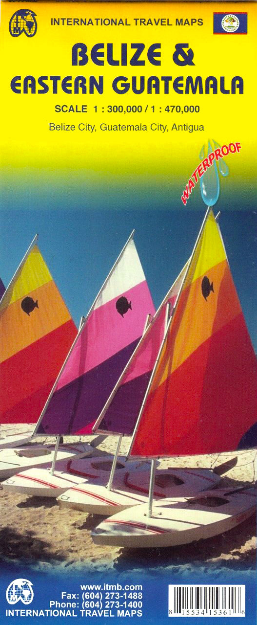
Belize & Eastern Guatemala ITMB Map
$24.95
Afterpay is only available for orders between $50.00 and $1000.00 More info
Durable Waterproof Edition • Double-Sided • Includes Tikal & Guatemala City
This updated Belize & Eastern Guatemala Travel Map by ITMB (International Travel Maps) is an essential companion for explorers heading to Central America's most accessible tropical adventure zones. Perfectly tailored for travellers who base themselves in Belize but plan to visit key destinations in neighbouring Guatemala—especially the legendary ruins of Tikal—this dual-country map delivers clarity, convenience, and added value.
🗺️ Map Features at a Glance
| Feature | Details |
|---|---|
| Map Scale | 1:300,000 (Belize) / 1:470,000 (Eastern Guatemala) |
| Sheet Size | 690 mm (W) x 1000 mm (H) |
| Printing Format | Double-sided, folded |
| Material | Printed on durable waterproof plastic paper for field use |
| Cities Featured | Includes detailed street plans of Belize City and Guatemala City |
| Edition Enhancements | Updated road networks, national parks, archaeological zones |
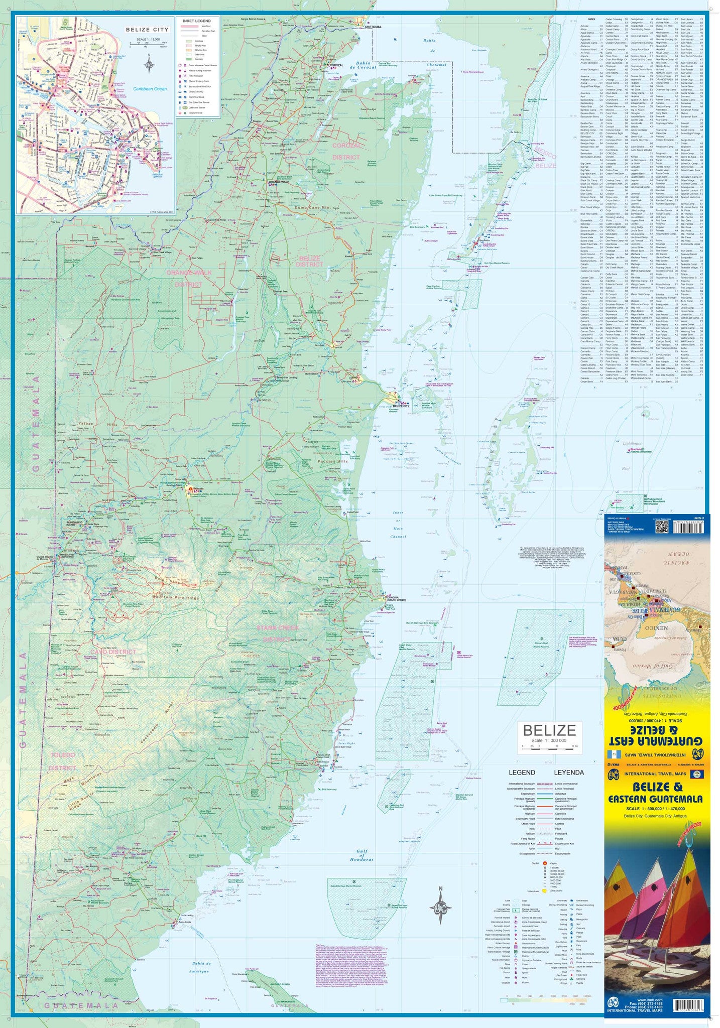
🌴 Side One: Belize in Detail
-
Full country coverage with topographic and road information
-
Updated Belize City inset map with key points of interest
-
Highlights national parks, marine reserves, islands, and reef zones
-
Roads colour-coded by surface quality and access
-
Border crossings and tourist access points clearly marked
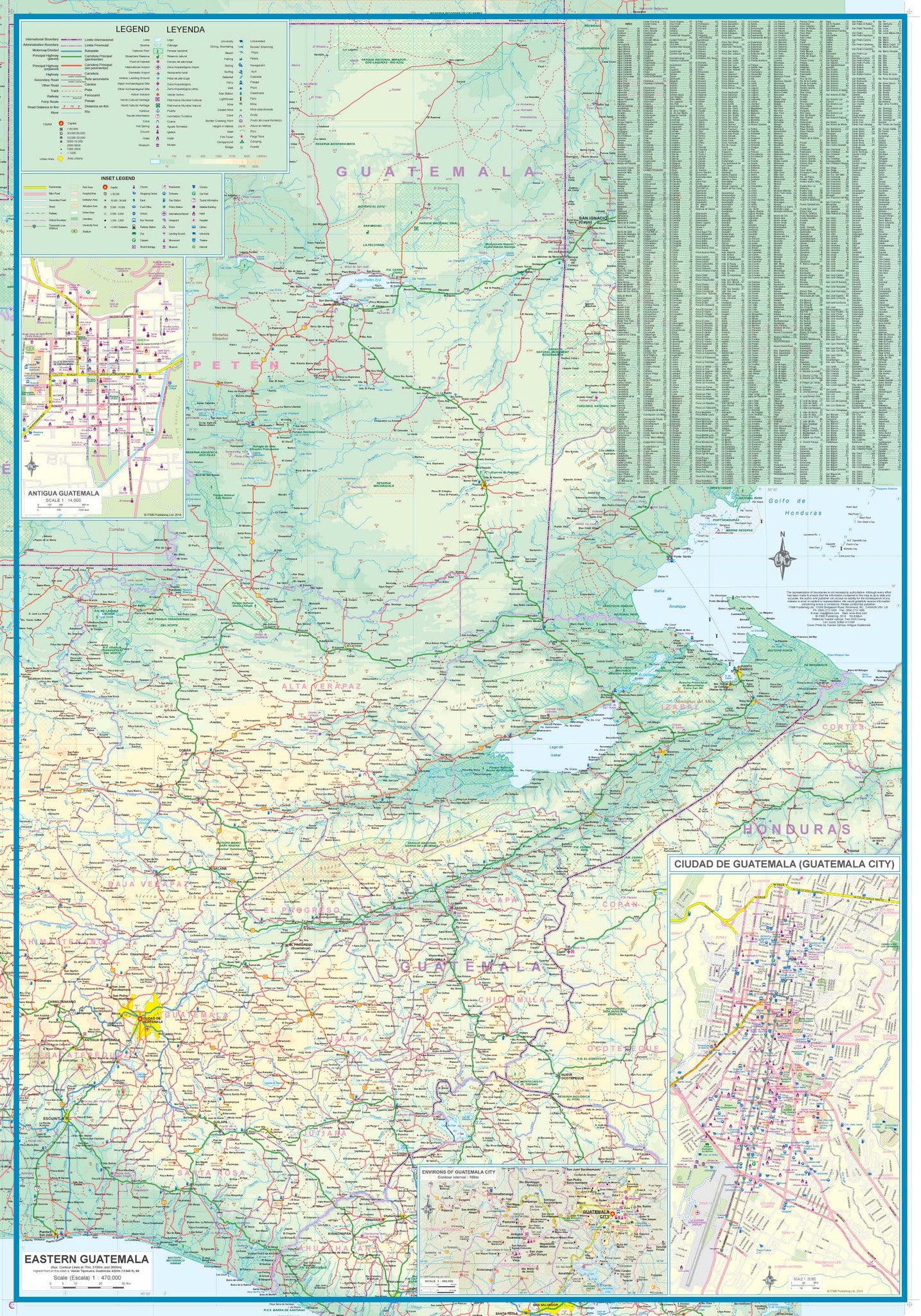
🏛️ Side Two: Eastern Guatemala & the Tikal Region
-
Covers the Petén Department, home to Tikal National Park
-
Major access routes from Belize into Guatemala
-
Includes a detailed city map of Guatemala City, ideal for those flying in or transiting through
-
Highlights include Lake Petén Itzá, Flores, and the Rio Dulce corridor
🧭 Why This Map?
✔️ Two countries, one map – Save space and simplify planning
✔️ Perfect for Tikal visitors – Avoid buying a separate Guatemala map
✔️ Waterproof & tear-resistant – Built for the tropics and backpacking
✔️ Field-tested detail – Developed by ITMB with on-the-ground cartographic expertise
✔️ Ideal for planning routes, day trips, and regional exploration
🛡️ Optional Lamination Upgrade
Upgrade your map to a laminated version for even more durability. Lamination allows:
-
Use of whiteboard markers
-
Application of map dots
-
Protection against rips, stains, and humidity
Note: Laminated versions are flattened and encapsulated using 80-micron gloss laminate. Slight fold lines may still be visible from the original folded map.
🌎 Ideal For
-
Adventure travellers heading to Tikal from Belize
-
Eco-tourists exploring Belize's cayes and reefs
-
Overlanders and road-trippers navigating border crossings
-
Students and educators studying Central American geography
Get the best of both worlds—Caribbean beaches and ancient Mayan cities—with this practical and beautifully printed map. Durable, detailed, and ready to travel.
Frequently Asked Questions
Where can I buy the Belize & Eastern Guatemala ITMB Map?
The Belize & Eastern Guatemala ITMB Map is available to buy online from Mapworld, Australia's largest map and geographic product retailer, with fast shipping Australia-wide.
Is the Belize & Eastern Guatemala ITMB Map in stock at Mapworld?
Mapworld maintains extensive stock across its map range and aims for fast dispatch. Orders placed before 2pm AEST on business days are typically dispatched the same day, with standard and express Australia-wide delivery options available.
What is Mapworld's returns policy?
Mapworld accepts returns on undamaged items in original condition. Contact Mapworld within 90 days of purchase to arrange a return or exchange.
Does Mapworld ship the Belize & Eastern Guatemala ITMB Map across Australia?
Yes, Mapworld ships Australia-wide. Standard shipping is a flat $7 rate, with free standard shipping on orders over $75. Express options are available at checkout. Most orders placed before 2pm AEST on weekdays are dispatched same day.
Related Items


© 2026 Mapworld. Website designed by Genie Media
X