- Australia ▾
- Topographic
▾
- Australia AUSTopo 250k (2025)
- Australia 50k Geoscience maps
- Australia 100k Geoscience maps
- Australia 250k Geoscience maps
- Australia 1:1m Geoscience maps
- New Zealand 50k maps
- New Zealand 250k maps
- New South Wales 25k maps
- New South Wales 50k maps
- New South Wales 100k maps
- Queensland 10k maps
- Queensland 25k maps
- Queensland 50k maps
- Queensland 100k maps
- Western Australia 25k maps
- Western Australia 50k maps
- Western Australia 100k maps
- Compasses
- Software
- GPS Systems
- International ▾
- Wall Maps
▾
- World
- Australia & New Zealand
- Countries, Continents & Regions
- Historical
- Vintage National Geographic
- Australian Capital Territory
- New South Wales
- Northern Territory
- Queensland
- South Australia
- Tasmania
- Victoria
- Western Australia
- Celestial
- Children's
- Mining & Resources
- Wine Maps
- Healthcare
- Postcode Maps
- Electoral Maps
- Nautical ▾
- Flags
▾
- Australian Flag Sets & Banners
- Flag Bunting
- Handwavers
- Australian National Flags
- Aboriginal Flags
- Torres Strait Islander Flags
- International Flags
- Flagpoles & Accessories
- Australian Capital Territory Flags
- New South Wales Flags
- Northern Territory Flags
- Queensland Flags
- South Australia Flags
- Tasmania Flags
- Victoria Flags
- Western Australia Flags
- Gifts ▾
- Globes ▾
Dear valued customer. Please note that our checkout is not supported by old browsers. Please use a recent browser to access all checkout capabilities


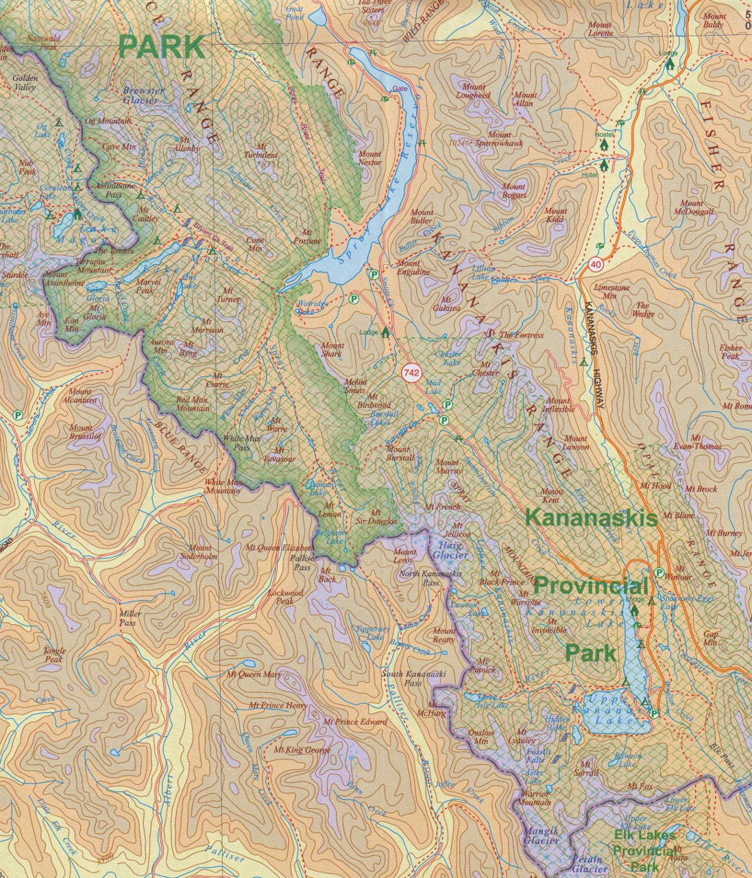
Banff & Jasper National Parks ITMB Map
$24.95
Afterpay is only available for orders between $50.00 and $1000.00 More info
Explore the Canadian Rockies in Exceptional Detail
Immerse yourself in the spectacular wilderness of Canada’s most iconic national parks with this beautifully detailed travel map of Banff and Jasper National Parks by International Travel Maps (ITMB). Known for their towering peaks, turquoise lakes, alpine meadows, and pristine wilderness, Banff and Jasper are dream destinations for road trippers, hikers, campers, and nature lovers.
This double-sided map includes both national parks at a scale of 1:300,000, providing expansive coverage of the entire region. Whether you're navigating the Icefields Parkway, finding the perfect campsite near Lake Louise, or exploring the backcountry trails of Maligne Canyon, this map is your trusted companion.
🌲 Map Features
-
🗺️ Covers Both Banff & Jasper National Parks
A single, double-sided map featuring comprehensive coverage of both park regions in Alberta. -
🛣️ Roads, Trails & Scenic Routes
Shows highways, park roads, unsealed routes, and hiking trails—including the famed Icefields Parkway (Highway 93). -
⛺ Camping & Accommodation
Highlights campgrounds, lodges, and accommodation options within and around the parks. -
🗻 Natural Attractions & Viewpoints
Includes lakes, glaciers, hot springs, waterfalls, picnic areas, and visitor centres. -
🧭 Topographic Relief Shading
Clearly conveys the mountainous terrain of the Canadian Rockies with contour shading and elevation markings. -
🏞️ Inset Maps
-
Banff townsite – Detailed layout of Canada’s only real town within a national park
-
Lake Louise – Resort village and access to hiking trails and Moraine Lake
-
Jasper – Gateway to the northern part of the Icefields Parkway
-
-
📍 Tourist Facilities & Services
Including hot springs, information centres, trailheads, and scenic stops.
📐 Specifications
| Feature | Detail |
|---|---|
| Scale | 1:300,000 |
| Map Size | 690 mm x 1000 mm (27" x 39") |
| Format | Double-sided, folded |
| Edition | 4th Edition |
| Publisher | ITMB (International Travel Maps) |
| ISBN | 9781771294829 |
💎 Lamination Upgrade Available
We offer this map in a fully laminated format, ideal for travel, educational use, or display.
-
✅ Use whiteboard markers to plan routes or annotate
-
✅ Apply map dots or tabs without damaging the surface
-
✅ Waterproof, stain-resistant, and tear-resistant
-
✅ Laminated using true encapsulation with 80-micron gloss laminate
-
🔔 Please note: Lamination is applied to a flattened folded map, so *minor fold lines will still be visible.
📦 Delivery Notes
🛠️ This map is printed to order. Please allow 7–10 working days for lamination and dispatch.
🌄 Why Choose This Map?
If you're planning a road trip through the Canadian Rockies, camping beneath starlit skies, hiking to alpine lakes, or simply admiring nature from your RV, this Banff & Jasper National Parks ITMB Map is the ultimate resource. With clear cartography, practical detail, and rugged build quality, it’s designed for real adventure.
Frequently Asked Questions
Where can I buy the Banff & Jasper National Parks ITMB Map?
The Banff & Jasper National Parks ITMB Map is available to buy online from Mapworld, Australia's largest map and geographic product retailer, with fast shipping Australia-wide.
Is the Banff & Jasper National Parks ITMB Map in stock at Mapworld?
Mapworld maintains extensive stock across its map range and aims for fast dispatch. Orders placed before 2pm AEST on business days are typically dispatched the same day, with standard and express Australia-wide delivery options available.
What is Mapworld's returns policy?
Mapworld accepts returns on undamaged items in original condition. Contact Mapworld within 90 days of purchase to arrange a return or exchange.
Does Mapworld ship the Banff & Jasper National Parks ITMB Map across Australia?
Yes, Mapworld ships Australia-wide. Standard shipping is a flat $7 rate, with free standard shipping on orders over $75. Express options are available at checkout. Most orders placed before 2pm AEST on weekdays are dispatched same day.
Related Items


© 2026 Mapworld. Website designed by Genie Media
X