- Australia ▾
- Topographic
▾
- Australia AUSTopo 250k (2025)
- Australia 50k Geoscience maps
- Australia 100k Geoscience maps
- Australia 250k Geoscience maps
- Australia 1:1m Geoscience maps
- New Zealand 50k maps
- New Zealand 250k maps
- New South Wales 25k maps
- New South Wales 50k maps
- New South Wales 100k maps
- Queensland 10k maps
- Queensland 25k maps
- Queensland 50k maps
- Queensland 100k maps
- Compasses
- Software
- GPS Systems
- Orienteering
- International ▾
- Wall Maps
▾
- World
- Australia & New Zealand
- Countries, Continents & Regions
- Historical
- Vintage National Geographic
- Australian Capital Territory
- New South Wales
- Northern Territory
- Queensland
- South Australia
- Tasmania
- Victoria
- Western Australia
- Celestial
- Children's
- Mining & Resources
- Wine Maps
- Healthcare
- Postcode Maps
- Electoral Maps
- Nautical ▾
- Flags
▾
- Australian Flag Sets & Banners
- Flag Bunting
- Handwavers
- Australian National Flags
- Aboriginal Flags
- Torres Strait Islander Flags
- International Flags
- Flagpoles & Accessories
- Australian Capital Territory Flags
- New South Wales Flags
- Northern Territory Flags
- Queensland Flags
- South Australia Flags
- Tasmania Flags
- Victoria Flags
- Western Australia Flags
- Gifts ▾
- Globes ▾
Dear valued customer. Please note that our checkout is not supported by old browsers. Please use a recent browser to access all checkout capabilities


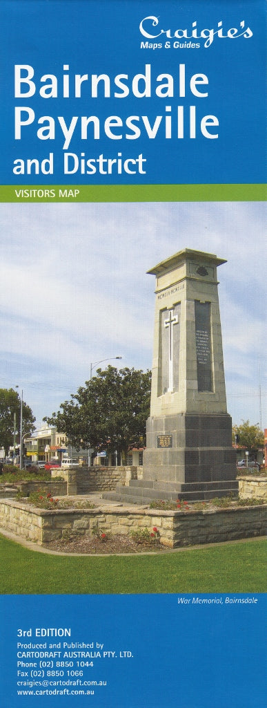
Bairnsdale, Paynesville & District Craigies Map
$14.95
Afterpay is only available for orders between $50.00 and $1000.00 More info
Bairnsdale, Paynesville & District Map — Craigies
Comprehensive local navigation across East Gippsland’s thriving coastal and inland towns
Whether you’re exploring the stunning Gippsland Lakes, relocating to the region, or planning local delivery and transport routes, the Craigies Bairnsdale, Paynesville & District Map is your essential guide. This expertly designed map provides a clear and reliable reference for navigating the towns and surrounding districts of Bairnsdale, Paynesville, Bruthen, and beyond — capturing the perfect balance between street-level detail and regional coverage.
📍 Coverage Area
This thoughtfully designed map encompasses a generous portion of East Gippsland, making it ideal for locals, tourists, and regional businesses. Coverage extends:
-
North to the township of Bruthen, gateway to the Alpine region
-
South to the shores of Loch Sport, on the edge of the Ninety Mile Beach and Gippsland Lakes
-
East to Nowa Nowa, a key stop on the Princes Highway
-
West to Meerlieu, connecting rural properties and farmlands
This broad scope ensures seamless travel planning across townships, lakefront settlements, rural communities, and coastal reserves.
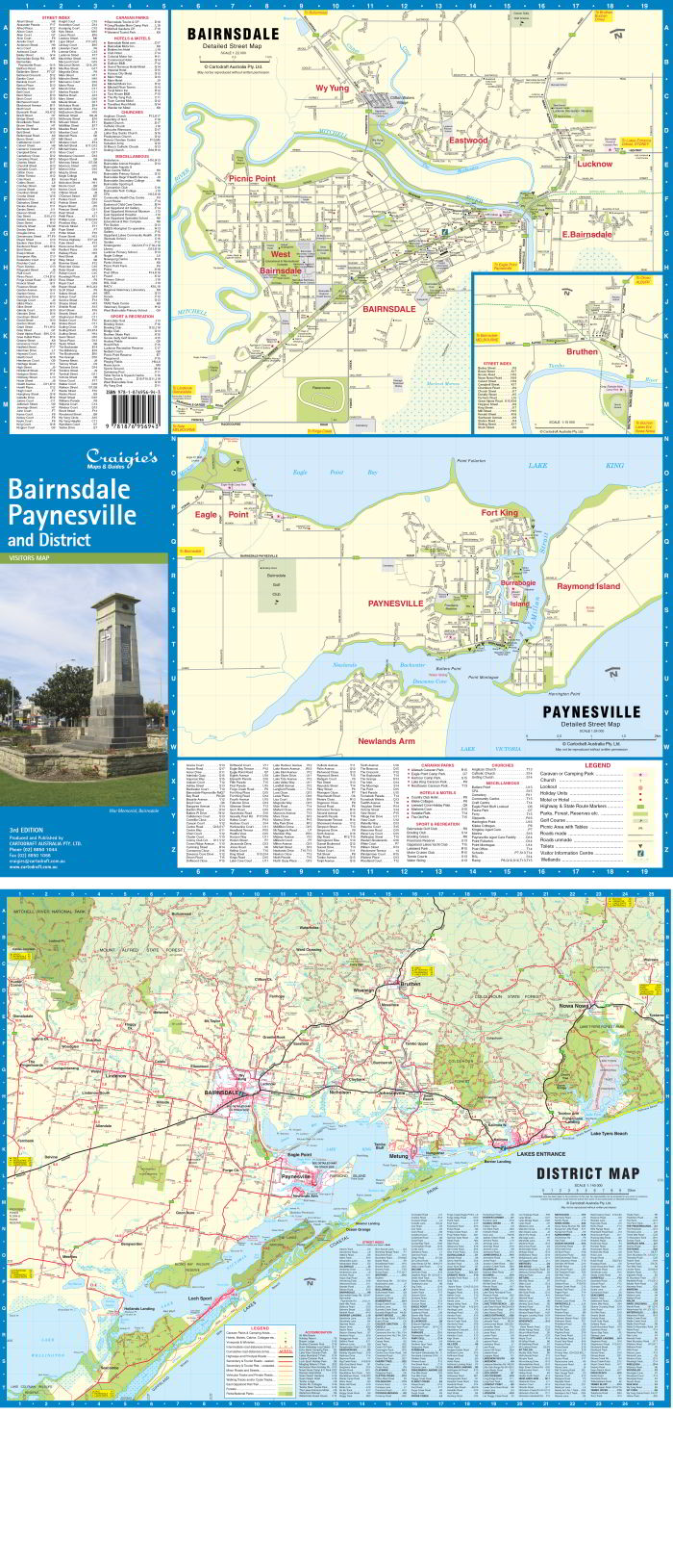
🧭 Map Features & Scales
This map includes both detailed street-level views and a large-scale regional overview for broader travel:
| Map Section | Scale | Details |
|---|---|---|
| District Map | 1:140,000 | Shows main and secondary roads, highways, towns, regional boundaries, water bodies, and scenic routes |
| Bairnsdale Street Map | 1:22,000 | Covers residential areas, industrial zones, CBD layout, schools, medical centres, and civic buildings |
| Paynesville Street Map | 1:24,000 | Displays marina access, local streets, boat ramps, shops, and recreation spaces in this popular waterside town |
| Bruthen Inset Map | Varies | Detailed inset of this quaint village, ideal for exploring its riverside setting and local amenities |
All maps are labelled with street names, points of interest, and clear symbology, making them easy to read for both locals and visitors.
🏕️ What You'll Find On This Map
-
🏡 Residential Streets and subdivisions clearly marked
-
🏥 Hospitals, clinics, and health centres
-
🏫 Schools, sports facilities, and community hubs
-
🛍️ Retail zones, shopping strips, and CBD layouts
-
🛶 Lakeside infrastructure: jetties, marinas, and access ramps
-
🏞️ Recreation and green spaces: parks, reserves, trails
-
🚗 Highways, regional connectors, and minor roads
-
⛽ Fuel stops, rest areas, and transport depots
-
🌿 Nearby national parks and forest boundaries
Perfect for planning scenic drives, local delivery routes, or weekend getaways across East Gippsland’s diverse terrain.
🎯 Who This Map Is For
-
✅ Residents & new arrivals looking to familiarise themselves with the region
-
✅ Holidaymakers exploring the Gippsland Lakes, boating routes, or local towns
-
✅ Local businesses & delivery drivers needing precise navigation tools
-
✅ Grey nomads & caravaners planning extended East Gippsland road trips
-
✅ Real estate agents, service technicians, & town planners requiring street-level reference
-
✅ Visitors with a love of maps — excellent for display or glovebox use
🧾 Product Specifications
| Specification | Detail |
|---|---|
| Publisher | Craigies Maps Australia |
| Format | Folded Paper Map |
| Edition | Latest edition available |
| Map Type | District map with town insets |
| Open Size | Approx. 700 mm x 1000 mm |
| Weight | Lightweight and easy to carry |
| Finish | Paper |
💡 Why Choose This Craigies Map?
-
✅ Australian-made and focused on local accuracy
-
✅ Easy-to-read formatting for stress-free navigation
-
✅ Detailed town maps not included in general road atlases
-
✅ Ideal for personal, commercial, and tourist use
-
✅ Affordable and long-lasting reference tool
Whether you're boating on Lake King, wandering the streets of Bairnsdale, or heading toward the mountains or coast, this map ensures you're never lost and always informed.
Navigate confidently. Explore meaningfully. Travel prepared — with Craigies
Frequently Asked Questions
Where can I buy the Bairnsdale, Paynesville & District Craigies Map?
The Bairnsdale, Paynesville & District Craigies Map is available to buy online from Mapworld, Australia's largest map and geographic product retailer, with fast shipping Australia-wide.
Is the Bairnsdale, Paynesville & District Craigies Map in stock at Mapworld?
Mapworld maintains extensive stock across its map range and aims for fast dispatch. Orders placed before 2pm AEST on business days are typically dispatched the same day, with standard and express Australia-wide delivery options available.
What is Mapworld's returns policy?
Mapworld accepts returns on undamaged items in original condition. Contact Mapworld within 90 days of purchase to arrange a return or exchange.
Does Mapworld ship the Bairnsdale, Paynesville & District Craigies Map across Australia?
Yes, Mapworld ships Australia-wide. Standard shipping is a flat $7 rate, with free standard shipping on orders over $75. Express options are available at checkout. Most orders placed before 2pm AEST on weekdays are dispatched same day.
Related Items


© 2026 Mapworld. Website designed by Genie Media
X