- Australia ▾
- Topographic
▾
- Australia AUSTopo 250k (2024)
- Australia 50k Geoscience maps
- Australia 100k Geoscience maps
- Australia 250k Geoscience maps
- Australia 1.1m Geoscience maps
- New Zealand 50k maps
- New Zealand 250k maps
- New South Wales 25k maps
- New South Wales 50k maps
- New South Wales 100k maps
- Queensland 10k maps
- Queensland 25k maps
- Queensland 50k maps
- Queensland 100k maps
- Compasses
- Software
- GPS Systems
- Orienteering
- International ▾
- Wall Maps
▾
- World
- Australia & New Zealand
- Countries, Continents & Regions
- Historical
- Vintage National Geographic
- Australian Capital Territory
- New South Wales
- Northern Territory
- Queensland
- South Australia
- Tasmania
- Victoria
- Western Australia
- Celestial
- Children's
- Mining & Resources
- Wine Maps
- Healthcare
- Postcode Maps
- Electoral Maps
- Nautical ▾
- Flags
▾
- Australian Flag Sets & Banners
- Flag Bunting
- Handwavers
- Australian National Flags
- Aboriginal Flags
- Torres Strait Islander Flags
- International Flags
- Flagpoles & Accessories
- Australian Capital Territory Flags
- New South Wales Flags
- Northern Territory Flags
- Queensland Flags
- South Australia Flags
- Tasmania Flags
- Victoria Flags
- Western Australia Flags
- Gifts ▾
- Globes ▾
Dear valued customer. Please note that our checkout is not supported by old browsers. Please use a recent browser to access all checkout capabilities
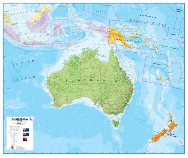
Australasia Political Maps International 1200 x 1000mm Wall Map
$129.95
or make 4 interest-free payments of
$32.49 AUD
fortnightly with
![]() More info
More info
Australia, New Zealand, Indonesia & Papua New Guinea in One Stunning View
Bring the wider Asia-Pacific region into sharp focus with this beautifully presented Australasia Political Wall Map by Maps International—one of the very few maps to offer a dedicated, comprehensive view of Australia, New Zealand, Indonesia, Papua New Guinea, and surrounding nations on a single sheet.
This vibrant and informative map combines eye-catching colour palettes with subtle relief shading to depict both political boundaries and physical geography, making it as engaging as it is educational. Whether you're planning trade routes, tracing migration patterns, or simply looking to enhance a wall with cartographic charm, this is a map that balances clarity, beauty, and substance.
Why This Map Stands Out
-
Unique Regional Coverage
One of the only maps to showcase the full sweep of Australasia—including:-
Australia
-
New Zealand
-
Indonesia
-
Papua New Guinea
-
Timor-Leste
-
And neighbouring Pacific islands
-
-
Clear Political Borders with Topographic Relief
Bold country and state boundaries for easy reference, enhanced by relief shading that adds depth and visual interest to mountainous and coastal regions. -
Multi-Purpose Design
Perfect for:-
Classrooms & lecture theatres
-
Offices and logistics rooms
-
Home studies or kids' bedrooms
-
Travel enthusiasts and Australasia buffs
-
📐 Specifications
| Feature | Details |
|---|---|
| Map Title | Australasia Political Wall Map |
| Publisher | Maps International |
| Coverage | Australia, NZ, Indonesia, PNG & more |
| Style | Political with shaded relief |
| Map Size (Unframed) | 1200 mm (W) x 1000 mm (H) |
| Print Type | Pigment-based ink on 160 gsm matte paper |
| Finish Options | Paper / Laminated / Canvas |
| Country of Manufacture | Made in Australia |
Available Finishes
Choose the version that suits your space and usage:
-
Standard Paper Print
-
Ideal for framing under glass
-
Lightweight and crisp with rich, archival pigment tones
-
-
Laminated Finish
-
Encapsulated between two sheets of 80-micron gloss laminate
-
Durable, waterproof, tear-resistant
-
Write-on/wipe-off compatible with whiteboard markers
-
Perfect for planning or educational use
-
-
Canvas Option (395gsm HP Matte Canvas)
-
Premium material for a gallery-quality finish
-
Printed with fade-resistant pigment inks
-
Highly durable, flexible, and perfect for long-term display
-
-
Hang-Railed Laminated & Canvas (Optional)
-
Stretched between wooden natural timber rails, top and bottom
-
Comes ready to hang with attached cord
-
A stylish and practical solution for any wall
-
(Please allow 10 working days for hang-railed maps—custom assembled by our framer)
-
🧭 Ideal For
-
📚 Educators and Geography Teachers
-
🌍 Businesses operating in the Asia-Pacific region
-
📦 Logistics and export planning
-
🎁 A sophisticated gift for globetrotters or students
-
🏠 Elegant décor for modern interiors with a global theme
Highlight the dynamic geography of Australasia with a map that informs, inspires, and endures. Whether you're teaching, exploring, or simply admiring the world's most remote and diverse region, the Maps International Australasia Political Map is an essential addition to your collection.
Know your region. See it all in one place.


