- Australia ▾
- Topographic
▾
- Australia AUSTopo 250k (2025)
- Australia 50k Geoscience maps
- Australia 100k Geoscience maps
- Australia 250k Geoscience maps
- Australia 1:1m Geoscience maps
- New Zealand 50k maps
- New Zealand 250k maps
- New South Wales 25k maps
- New South Wales 50k maps
- New South Wales 100k maps
- Queensland 10k maps
- Queensland 25k maps
- Queensland 50k maps
- Queensland 100k maps
- Compasses
- Software
- GPS Systems
- Orienteering
- International ▾
- Wall Maps
▾
- World
- Australia & New Zealand
- Countries, Continents & Regions
- Historical
- Vintage National Geographic
- Australian Capital Territory
- New South Wales
- Northern Territory
- Queensland
- South Australia
- Tasmania
- Victoria
- Western Australia
- Celestial
- Children's
- Mining & Resources
- Wine Maps
- Healthcare
- Postcode Maps
- Electoral Maps
- Nautical ▾
- Flags
▾
- Australian Flag Sets & Banners
- Flag Bunting
- Handwavers
- Australian National Flags
- Aboriginal Flags
- Torres Strait Islander Flags
- International Flags
- Flagpoles & Accessories
- Australian Capital Territory Flags
- New South Wales Flags
- Northern Territory Flags
- Queensland Flags
- South Australia Flags
- Tasmania Flags
- Victoria Flags
- Western Australia Flags
- Gifts ▾
- Globes ▾
Dear valued customer. Please note that our checkout is not supported by old browsers. Please use a recent browser to access all checkout capabilities


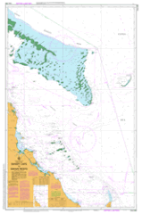
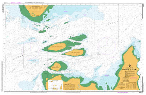
AUS 490 - Sandy Cape To Swain Reefs Nautical Chart
$49.95
Afterpay is only available for orders between $50.00 and $1000.00 More info
AUS 490 — Sandy Cape to Swain Reefs, QLD Nautical Chart
For skippers, pilots, and coastal crews planning the Sandy Cape–Swain Reefs coastal overview
Plan confident long-leg passages with AUS 490. This broad-coverage sheet delivers the sector at 1:500,000 on Mercator projection—ideal for big-picture route shaping, landfall bearings, safe offings, and waypoint checks along Queensland’s outer GBR approaches.
Why skippers choose this chart
-
🧭 Built for overview passages — Main sheet at 1:500,000 from Sandy Cape through the Swain Reefs.
-
🚢 Traffic & approach awareness — Helps set safe offings and landfall strategies before switching to larger-scale charts.
-
🛰️ Mercator projection — Straightforward bearings and GPS plotting over longer runs.
-
📍 Exact bounds — All four limits listed for quick position checks (see below).
-
🗺️ Deck-ready materials — Writeable laminate front face for chart-correction pencils.
-
🇦🇺 Printed in Australia — Colour-managed, hand-checked.
Coverage
-
Main Chart — AUS 490: Australia East Coast · Queensland · Sandy Cape to Swain Reefs
-
Scale: 1:500,000 · Projection: Mercator
-
Bounds: N 19°59.00′ S · S 24°50.00′ S · E 153°52.00′ E · W 150°34.00′ E
-
Publication: — · Latest Edition: 01-Aug-2014 (Edition 2)
-
Premium materials & finishes
-
Paper (120 gsm matte) — Crisp, flexible and chart-table friendly; ideal under nav-station glass.
-
Laminated (soft-matte front / gloss back, edge-sealed) — Front side is low-glare and writeable with chart-correcting/grease pencils; gloss back adds rigidity. Wipes clean with a soft cloth.
Note: We’ve intentionally configured the laminate with a soft-matte writeable face and a gloss reverse so you can annotate pilotage notes, fixes and ETAs directly on the chart, then clean down between passages.
On-board & ashore use
-
🧭 Passage planning — Shape long-range tracks, offings and contingency points.
-
📒 Crew briefings — Big-picture layout for approach strategies and waypoint checks.
-
🛠️ Bridge/club display — Durable laminated option for noticeboards and training rooms.
-
🎁 Gift for skippers — A practical, good-looking overview for Queensland voyaging.
Specifications
| Field | Detail |
|---|---|
| Chart Number | AUS 490 |
| Title | Australia East Coast — Queensland — Sandy Cape to Swain Reefs |
| Geographic Location | Australia |
| Scale (main) | 1:500,000 |
| Projection | Mercator |
| North / South Limits | 19°59.00′ S / 24°50.00′ S |
| East / West Limits | 153°52.00′ E / 150°34.00′ E |
| Publication Date | — |
| Latest Edition | 01-Aug-2014 (Edition 2) |
| Sheet Size | 770 mm (W) × 1100 mm (H) |
| Available Finishes | Paper (120 gsm matte); Laminated (soft-matte writeable front, gloss back, edge-sealed) |
| Inks | Pigment-based, fade-resistant |
| Origin | Printed in Australia |
Important note (mariner’s guidance)
This product is ideal for planning, briefing, education, and display. For underway navigation, always carry and consult the latest official hydrographic chart or approved ECDIS and current Notices to Mariners. Local conditions and aids may change.
Ready to plan Sandy Cape to the Swain Reefs?
Select your finish above and add to cart. We’ll print locally, hand-check, and ship with care.