- Australia ▾
- Topographic
▾
- Australia AUSTopo 250k (2024)
- Australia 50k Geoscience maps
- Australia 100k Geoscience maps
- Australia 250k Geoscience maps
- Australia 1.1m Geoscience maps
- New Zealand 50k maps
- New Zealand 250k maps
- New South Wales 25k maps
- New South Wales 50k maps
- New South Wales 100k maps
- Queensland 10k maps
- Queensland 25k maps
- Queensland 50k maps
- Queensland 100k maps
- Compasses
- Software
- GPS Systems
- Orienteering
- International ▾
- Wall Maps
▾
- World
- Australia & New Zealand
- Countries, Continents & Regions
- Historical
- Vintage National Geographic
- Australian Capital Territory
- New South Wales
- Northern Territory
- Queensland
- South Australia
- Tasmania
- Victoria
- Western Australia
- Celestial
- Children's
- Mining & Resources
- Wine Maps
- Healthcare
- Postcode Maps
- Electoral Maps
- Nautical ▾
- Flags
▾
- Australian Flag Sets & Banners
- Flag Bunting
- Handwavers
- Australian National Flags
- Aboriginal Flags
- Torres Strait Islander Flags
- International Flags
- Flagpoles & Accessories
- Australian Capital Territory Flags
- New South Wales Flags
- Northern Territory Flags
- Queensland Flags
- South Australia Flags
- Tasmania Flags
- Victoria Flags
- Western Australia Flags
- Gifts ▾
- Globes ▾
Dear valued customer. Please note that our checkout is not supported by old browsers. Please use a recent browser to access all checkout capabilities
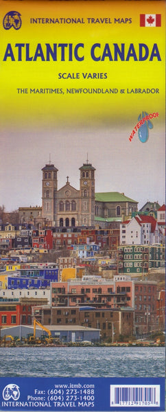
Atlantic Canada ITMB Map
$24.95
Afterpay is only available for orders between $50.00 and $1000.00 More info
Explore the East Coast of Canada with One Beautifully Detailed Map
🇨🇦 Your All-in-One Map for Atlantic Canada
Whether you're planning a road trip along the Cabot Trail, exploring the lighthouses of Prince Edward Island, or sailing past the fjords of Newfoundland, this Atlantic Canada ITMB Map is the ultimate companion for your eastern Canadian adventure.
Printed on durable, waterproof, and eco-friendly stone paper, this double-sided map combines four fascinating and diverse regions of Canada into one convenient and practical sheet—perfect for travellers, educators, and adventurers alike.
🗺️ Map Coverage & Features
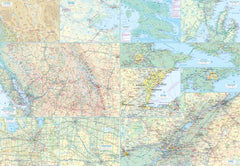
Side 1 – The Maritime Provinces
-
Covers Nova Scotia, New Brunswick, and Prince Edward Island, including the Magdalen Islands (Quebec)
-
Scale: 1:800,000 – ideal for regional travel planning and road navigation
-
Includes Top 10 Attractions for the Maritime provinces, highlighting must-see sites such as the Bay of Fundy, Peggy’s Cove, the Confederation Bridge, and more
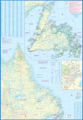
Side 2 – Newfoundland & Labrador
-
Main focus on Labrador (mainland) at 1:1,700,000 scale
-
Includes a half-page inset of Newfoundland Island at 1:150,000 scale for clearer coastal and settlement detail
-
Inset of St. John’s, one of North America’s oldest cities, highlighting streets, landmarks, and historical points
-
Bonus inclusion of St. Pierre & Miquelon, the nearby French overseas territory
-
Features a Top 9 Attractions list to guide your exploration of this vast, rugged province
🌧️ Printed on Waterproof Stone Paper
-
Waterproof & Tear-Resistant – Built for the outdoors and unpredictable Canadian weather
-
Eco-Friendly – Stone paper is compostable and free from tree pulp
-
Durable & Long-Lasting – Ideal for repeated folding, drawing, and reference use on the road
📐 Specifications
| Feature | Details |
|---|---|
| Map Title | Atlantic Canada ITMB Map |
| Map Type | Double-sided travel map |
| Provinces Covered | Nova Scotia, New Brunswick, Prince Edward Island, Newfoundland & Labrador |
| Top Attractions | Listed for both the Maritime provinces and Newfoundland & Labrador |
| Material | Waterproof, eco-friendly stone paper |
| Scale | 1:800,000 (Maritimes), 1:1,700,000 (Labrador), 1:150,000 (Newfoundland inset) |
| Inset Maps | St. John’s, St. Pierre & Miquelon |
| Size | 690 mm x 1000 mm (unfolded) |
| Publisher | ITMB (International Travel Maps) |
🧭 Ideal For:
-
Road-trippers planning a grand circle tour of Atlantic Canada
-
Cruise passengers visiting coastal ports across multiple provinces
-
Outdoor adventurers exploring national parks, lighthouses, coastal drives, and heritage sites
-
Travel agents and tour operators needing a single-sheet reference for Eastern Canada
-
Map collectors and cartography lovers
📌 Order yours today and experience the history, nature, and maritime culture of Atlantic Canada—beautifully mapped and ready for your next journey.


