- Australia ▾
- Topographic
▾
- Australia AUSTopo 250k (2025)
- Australia 50k Geoscience maps
- Australia 100k Geoscience maps
- Australia 250k Geoscience maps
- Australia 1:1m Geoscience maps
- New Zealand 50k maps
- New Zealand 250k maps
- New South Wales 25k maps
- New South Wales 50k maps
- New South Wales 100k maps
- Queensland 10k maps
- Queensland 25k maps
- Queensland 50k maps
- Queensland 100k maps
- Western Australia 25k maps
- Western Australia 50k maps
- Western Australia 100k maps
- Compasses
- Software
- GPS Systems
- International ▾
- Wall Maps
▾
- World
- Australia & New Zealand
- Countries, Continents & Regions
- Historical
- Vintage National Geographic
- Australian Capital Territory
- New South Wales
- Northern Territory
- Queensland
- South Australia
- Tasmania
- Victoria
- Western Australia
- Celestial
- Children's
- Mining & Resources
- Wine Maps
- Healthcare
- Postcode Maps
- Electoral Maps
- Nautical ▾
- Flags
▾
- Australian Flag Sets & Banners
- Flag Bunting
- Handwavers
- Australian National Flags
- Aboriginal Flags
- Torres Strait Islander Flags
- International Flags
- Flagpoles & Accessories
- Australian Capital Territory Flags
- New South Wales Flags
- Northern Territory Flags
- Queensland Flags
- South Australia Flags
- Tasmania Flags
- Victoria Flags
- Western Australia Flags
- Gifts ▾
- Globes ▾
Dear valued customer. Please note that our checkout is not supported by old browsers. Please use a recent browser to access all checkout capabilities


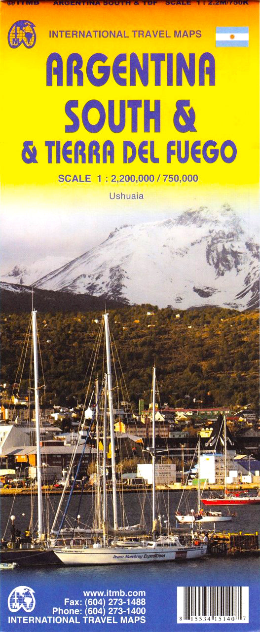
Argentina South & Tierra del Fuego ITMB Map
Sold Out
Afterpay is only available for orders between $50.00 and $1000.00 More info
🇦🇷 Argentina South & Tierra del Fuego Travel Map by ITMB
Double-Sided • Updated Cartography • Ideal for Patagonian Adventures
Scale: Southern Argentina 1:2,200,000 | Tierra del Fuego 1:750,000
Map Size: 690 mm x 1000 mm
Format: Folded (Laminated upgrade available)
🗺️ Discover the Rugged Beauty of Southern Argentina & Tierra del Fuego
This double-sided travel map from ITMB (International Travel Maps) offers a beautifully detailed view of Southern Argentina, from Patagonia’s wind-swept steppes and glacial landscapes to the iconic southern tip of the continent—Tierra del Fuego.
Whether you're planning a road trip along the Ruta Nacional 3, boarding a cruise to Antarctica, or trekking through the Andean foothills, this map is an essential tool for exploring one of the most dramatic and remote regions on Earth.
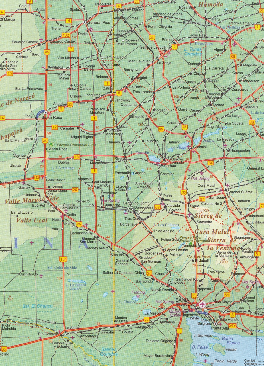
🇦🇷 Side 1: Southern Argentina – From Patagonia to the South Atlantic
The northern half of the map focuses on Argentina’s vast and sparsely populated southern regions, extending from Puerto Madryn and Península Valdés to the rugged Patagonian frontier.
Features include:
-
Detailed road network including highways and remote tracks
-
Key natural and touristic highlights: whale-watching areas, national parks, and coastal wildlife reserves
-
Mountain ranges, lakes, glaciers, and steppe terrain
-
Ferry routes, airport symbols, and international border crossings
-
Major cities and towns like Río Gallegos, Puerto Santa Cruz, and Comodoro Rivadavia
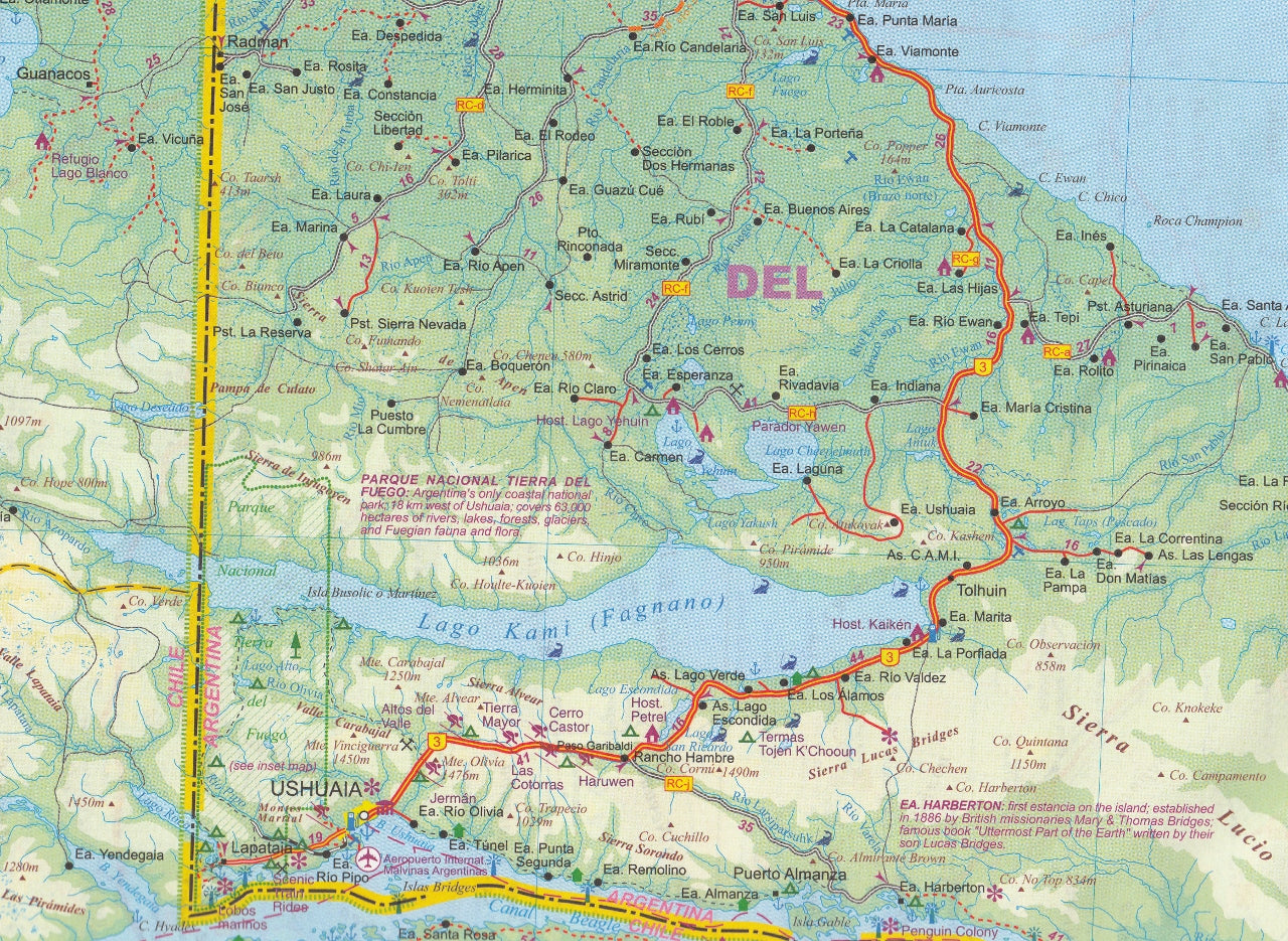
🔥 Side 2: Tierra del Fuego – The Legendary Land of Fire
The reverse side focuses on Tierra del Fuego, the remote island shared between Argentina and Chile at the southern tip of the continent.
Highlights include:
-
Detailed coverage of both the Argentine and Chilean sectors
-
National parks including Parque Nacional Tierra del Fuego
-
Ferry routes and key crossings through the Beagle Channel
-
An inset map of Ushuaia, the southernmost city in the world
-
Topography, roads, glaciers, and hiking zones
This region is not only a gateway to Antarctica, but a remarkable destination in its own right—ideal for eco-tourism, hiking, wildlife photography, and marine excursions.
✅ Laminated Version Available
Upgrade to our laminated version for maximum durability and flexibility:
-
Draw and plan with whiteboard markers
-
Use map dots to mark locations of interest
-
Tear-resistant, wipe-clean, and water-repellent
-
Laminated using high-quality 80-micron gloss on flattened maps
-
Note: faint fold lines from the original format may be visible
📌 Product Specifications
| Feature | Details |
|---|---|
| Publisher | ITMB – International Travel Maps |
| Print Format | Double-sided, folded |
| Optional Finish | Laminated with 80-micron gloss laminate |
| Size | 690 mm x 1000 mm |
| Scales | Argentina South: 1:2,200,000 Tierra del Fuego: 1:750,000 |
| Insets | Ushuaia (city detail) |
🎯 Ideal For:
-
✈️ Travellers exploring Patagonia, the Andes, and Ushuaia
-
🧭 Adventurers planning treks, cruises, or overland routes
-
🚐 Overlanders and vanlifers travelling south from Buenos Aires
-
🌎 Geography enthusiasts or educational collections
-
📚 Teachers and students exploring extreme geography
Order your Argentina South & Tierra del Fuego map today and navigate the awe-inspiring landscapes at the end of the Earth with clarity and confidence
Frequently Asked Questions
Where can I buy the Argentina South & Tierra del Fuego ITMB Map?
The Argentina South & Tierra del Fuego ITMB Map is available to buy online from Mapworld, Australia's largest map and geographic product retailer, with fast shipping Australia-wide.
Is the Argentina South & Tierra del Fuego ITMB Map in stock at Mapworld?
Mapworld maintains extensive stock across its map range and aims for fast dispatch. Orders placed before 2pm AEST on business days are typically dispatched the same day, with standard and express Australia-wide delivery options available.
What is Mapworld's returns policy?
Mapworld accepts returns on undamaged items in original condition. Contact Mapworld within 90 days of purchase to arrange a return or exchange.
Does Mapworld ship the Argentina South & Tierra del Fuego ITMB Map across Australia?
Yes, Mapworld ships Australia-wide. Standard shipping is a flat $7 rate, with free standard shipping on orders over $75. Express options are available at checkout. Most orders placed before 2pm AEST on weekdays are dispatched same day.
Related Items


© 2026 Mapworld. Website designed by Genie Media
X