- Australia ▾
- Topographic
▾
- Australia AUSTopo 250k (2024)
- Australia 50k Geoscience maps
- Australia 100k Geoscience maps
- Australia 250k Geoscience maps
- Australia 1.1m Geoscience maps
- New Zealand 50k maps
- New Zealand 250k maps
- New South Wales 25k maps
- New South Wales 50k maps
- New South Wales 100k maps
- Queensland 10k maps
- Queensland 25k maps
- Queensland 50k maps
- Queensland 100k maps
- Compasses
- Software
- GPS Systems
- Orienteering
- International ▾
- Wall Maps
▾
- World
- Australia & New Zealand
- Countries, Continents & Regions
- Historical
- Vintage National Geographic
- Australian Capital Territory
- New South Wales
- Northern Territory
- Queensland
- South Australia
- Tasmania
- Victoria
- Western Australia
- Celestial
- Children's
- Mining & Resources
- Wine Maps
- Healthcare
- Postcode Maps
- Electoral Maps
- Nautical ▾
- Flags
▾
- Australian Flag Sets & Banners
- Flag Bunting
- Handwavers
- Australian National Flags
- Aboriginal Flags
- Torres Strait Islander Flags
- International Flags
- Flagpoles & Accessories
- Australian Capital Territory Flags
- New South Wales Flags
- Northern Territory Flags
- Queensland Flags
- South Australia Flags
- Tasmania Flags
- Victoria Flags
- Western Australia Flags
- Gifts ▾
- Globes ▾
Dear valued customer. Please note that our checkout is not supported by old browsers. Please use a recent browser to access all checkout capabilities


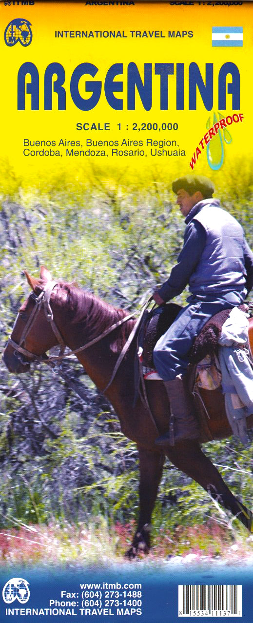
Argentina ITMB Map
$24.95
Afterpay is only available for orders between $50.00 and $1000.00 More info
Includes Detailed Buenos Aires Inset | Covers Most of Uruguay and Paraguay
Available Laminated or Paper Folded | Map Size: 690 × 1000 mm | Scale: 1:2,200,000
Your Gateway to South America’s Southern Giant
From the thunderous cascades of Iguazú to the icy silence of Patagonia, Argentina spans nearly 3,700 km of natural wonder, cultural richness, and dramatic geography. The Argentina ITMB Map (5th Edition) is a beautifully updated, double-sided travel map designed to make sense of this vast and varied land.
Produced by International Travel Maps (ITMB)—a respected name in global cartography—this map is tailored for travellers, road trippers, adventurers, researchers, and logistics planners alike. It captures Argentina’s evolving road network, the pulse of its cities, and the contours of its natural landmarks in crisp, easy-to-read detail.
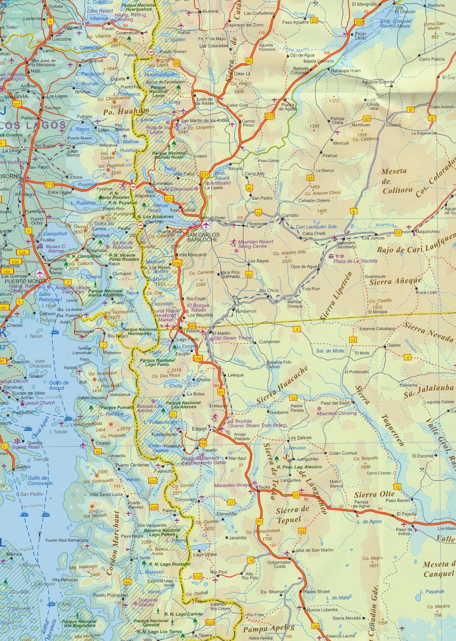
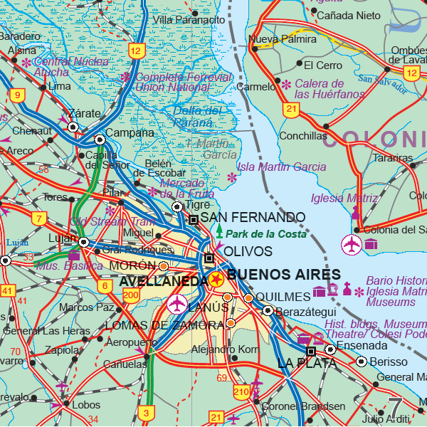
🗺️ Coverage & Content
| 🔍 What’s Included | ✅ Details |
|---|---|
| Main Map | Entirety of Argentina at 1:2,200,000 scale |
| Inset Map | High-detail map of Buenos Aires, Argentina’s capital |
| Neighbouring Regions | Includes Uruguay and parts of Paraguay for cross-border context |
| Transport Networks | Road classifications (highways, secondary roads), railways, ferry routes |
| Natural Features | Andes, rivers, national parks, lakes, pampas, coastal features |
| Tourism Highlights | Cities, towns, UNESCO sites, landmarks, provincial boundaries |
| Language | English map with bilingual place names where applicable |
Why This Map?
✅ Comprehensive National Coverage – Perfect for exploring Argentina’s enormous diversity, from Mendoza’s vineyards to Ushuaia’s frozen frontier.
✅ Updated Road Networks – Reflects ongoing upgrades to national and provincial infrastructure.
✅ Invaluable Inset of Buenos Aires – Navigate the capital’s layout, barrios, and arterial routes with confidence.
✅ Regional Context – Includes most of Uruguay and southern Paraguay—ideal for overland travellers.
✅ Double-Sided Layout – Printed front and back to maximize coverage without sacrificing legibility.
✅ Folded or Laminated Options – Choose between portability and wipeable durability.
📏 Product Specifications
| Attribute | Details |
|---|---|
| Map Type | Folded (standard) or Laminated |
| Scale | 1:2,200,000 |
| Size (Unfolded) | 690 mm × 1000 mm |
| Edition | 5th Edition |
| Publisher | ITMB – International Travel Maps |
| Printing | Full-colour, offset-printed |
✨ Lamination Option – For Lasting Use
Want your map to go the distance? Opt for laminated encapsulation, ideal for frequent use, outdoor settings, or planning and educational environments.
✔ Write-On, Wipe-Off Surface – Use whiteboard markers for routes or notes
✔ Compatible with Map Dots – Mark locations without damage
✔ Tear & Spill Resistant – Reinforced with 80-micron gloss laminate
✔ Note: Original fold lines from the paper map may still be visible post-lamination
🧳 Ideal For:
-
Overland travellers exploring Argentina by car or bus
-
Backpackers planning trans-continental routes
-
Academic research, logistics, or trade planning
-
Geography classrooms and educational settings
-
Anyone fascinated by the incredible scale and beauty of South America
📦 Shipping & Fulfilment
-
Folded Map: Ships flat-packed or folded, ready for travel
-
Laminated Map: Encapsulated, rolled, and shipped in a sturdy tube
-
Lead Time: Allow extra time for lamination (2–3 business days)
Argentina is no small country—and this is no ordinary map.
The Argentina ITMB Map gives you the clarity, detail, and confidence to navigate one of the world’s most geographically diverse nations.
🌍 Printed. Updated. Ready to Explore. Add to cart today and bring your South American journey into focus.


