- Australia ▾
- Topographic
▾
- Australia AUSTopo 250k (2024)
- Australia 50k Geoscience maps
- Australia 100k Geoscience maps
- Australia 250k Geoscience maps
- Australia 1.1m Geoscience maps
- New Zealand 50k maps
- New Zealand 250k maps
- New South Wales 25k maps
- New South Wales 50k maps
- New South Wales 100k maps
- Queensland 10k maps
- Queensland 25k maps
- Queensland 50k maps
- Queensland 100k maps
- Compasses
- Software
- GPS Systems
- Orienteering
- International ▾
- Wall Maps
▾
- World
- Australia & New Zealand
- Countries, Continents & Regions
- Historical
- Vintage National Geographic
- Australian Capital Territory
- New South Wales
- Northern Territory
- Queensland
- South Australia
- Tasmania
- Victoria
- Western Australia
- Celestial
- Children's
- Mining & Resources
- Wine Maps
- Healthcare
- Postcode Maps
- Electoral Maps
- Nautical ▾
- Flags
▾
- Australian Flag Sets & Banners
- Flag Bunting
- Handwavers
- Australian National Flags
- Aboriginal Flags
- Torres Strait Islander Flags
- International Flags
- Flagpoles & Accessories
- Australian Capital Territory Flags
- New South Wales Flags
- Northern Territory Flags
- Queensland Flags
- South Australia Flags
- Tasmania Flags
- Victoria Flags
- Western Australia Flags
- Gifts ▾
- Globes ▾
Dear valued customer. Please note that our checkout is not supported by old browsers. Please use a recent browser to access all checkout capabilities
Arab World in Arabic National Geographic Wall Map
$69.95
or make 4 interest-free payments of
$17.49 AUD
fortnightly with
![]() More info
More info
🌍 Arab World in Arabic – National Geographic Wall Map
Published 2019 | Produced with Qatar Foundation International | All Text in Arabic
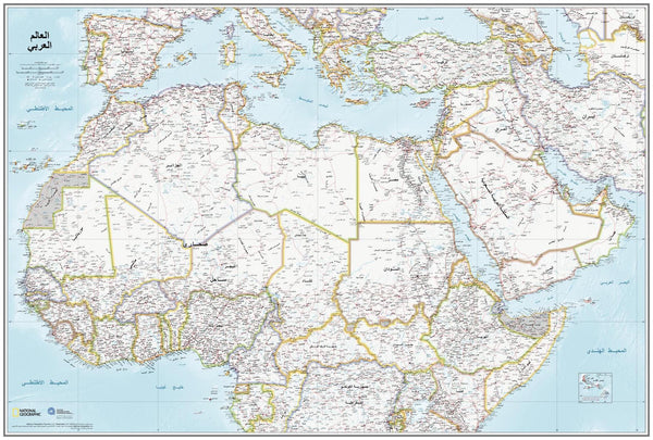
Created in partnership between National Geographic and the Qatar Foundation International, the Arab World in Arabic Wall Map combines world-class cartography with a dedication to promoting the Arabic language. This 2019 edition meets National Geographic’s exacting mapping standards while presenting all place names and text entirely in Arabic, making it a unique and definitive reference for Arabic-speaking audiences.
🗺️ Map Coverage
-
North Africa & Southern Europe – From Morocco to the eastern Mediterranean.
-
Middle East & Arabian Peninsula – Includes Turkey, Saudi Arabia, the Levant, and Gulf States.
-
East to Iran – Extending coverage to western Asia.
-
South to the Equator – Incorporating equatorial African nations for regional context.
Areas in dispute are clearly noted, with de facto borders and status annotations for clarity.
📜 Unique Feature – All Text in Arabic
Unlike most wall maps, every label, title, and annotation on this map is written in Arabic script. This makes it an ideal reference for Arabic speakers, Arabic language learners, cultural institutions, and schools seeking authentic, linguistically accurate geographic resources.
📐 Available Sizes
| Size | Dimensions |
|---|---|
| Standard | 610 mm (W) x 798 mm (H) |
| Supermap | 915 mm (W) x 1197 mm (H) |
✨ Available Finishes
| Format | Description |
|---|---|
| 🖨️ Paper (160 gsm) | Heavyweight matte-coated paper — perfect for framing under glass. |
| 🧼 Laminated (Encapsulated) | Sealed between two sheets of 80-micron gloss laminate. Wipe-clean, tear-resistant, and durable. |
| 🪵 Laminated with Wooden Hang Rails | Laminated map mounted with natural lacquered timber rails (top and bottom) and a hanging cord — ready to hang. |
| 🖼️ Canvas (395 gsm) | HP Professional Matte Canvas with archival pigment-based inks. Rich texture, fade-resistant, and gallery-quality. |
| 🪵 Canvas with Wooden Hang Rails | Canvas mounted with natural timber rails and a hanging cord for a timeless, ready-to-display look. |
🔨 Please allow up to 10 working days for delivery of hang-railed maps, as these are professionally mounted by our framer.
💡 Why You’ll Love This Map
✔️ All text in Arabic — a rare and valuable linguistic feature
✔️ National Geographic cartographic precision and design quality
✔️ Depicts current political boundaries and disputed areas with clarity
✔️ Two size options — Standard and large-format Supermap for maximum visibility
✔️ Available in five premium finishes for display or educational use
🎯 Perfect For
-
Arabic Speakers & Language Learners – An accurate geographic reference entirely in Arabic
-
Educational Institutions – Schools, universities, and cultural centres teaching Arabic or Middle Eastern studies
-
Libraries & Cultural Organisations – Promote linguistic diversity and cultural understanding
-
Home or Office Display – A striking and meaningful décor piece
🚚 Delivery
-
Paper, Laminated, Canvas: Ships within 1–2 business days
-
Hang-railed Maps (Laminated or Canvas): Ships within 10 working days (custom-mounted)
-
Packaging: Rolled in a heavy-duty postal tube for safe delivery
The Arab World in Arabic Wall Map is more than just a map — it’s a cultural and linguistic statement, combining National Geographic’s mapping expertise with the authenticity of Arabic script.
👉 Order today for a definitive, visually stunning reference to one of the most important regions in the world.


