- Australia ▾
- Topographic
▾
- Australia AUSTopo 250k (2024)
- Australia 50k Geoscience maps
- Australia 100k Geoscience maps
- Australia 250k Geoscience maps
- Australia 1.1m Geoscience maps
- New Zealand 50k maps
- New Zealand 250k maps
- New South Wales 25k maps
- New South Wales 50k maps
- New South Wales 100k maps
- Queensland 10k maps
- Queensland 25k maps
- Queensland 50k maps
- Queensland 100k maps
- Compasses
- Software
- GPS Systems
- Orienteering
- International ▾
- Wall Maps
▾
- World
- Australia & New Zealand
- Countries, Continents & Regions
- Historical
- Vintage National Geographic
- Australian Capital Territory
- New South Wales
- Northern Territory
- Queensland
- South Australia
- Tasmania
- Victoria
- Western Australia
- Celestial
- Children's
- Mining & Resources
- Wine Maps
- Healthcare
- Postcode Maps
- Electoral Maps
- Nautical ▾
- Flags
▾
- Australian Flag Sets & Banners
- Flag Bunting
- Handwavers
- Australian National Flags
- Aboriginal Flags
- Torres Strait Islander Flags
- International Flags
- Flagpoles & Accessories
- Australian Capital Territory Flags
- New South Wales Flags
- Northern Territory Flags
- Queensland Flags
- South Australia Flags
- Tasmania Flags
- Victoria Flags
- Western Australia Flags
- Gifts ▾
- Globes ▾
Dear valued customer. Please note that our checkout is not supported by old browsers. Please use a recent browser to access all checkout capabilities


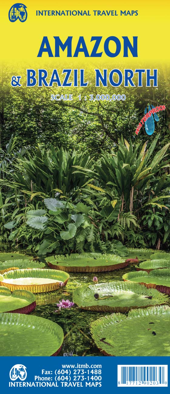


Amazon &Brazil North ITMB Map
$24.95
Afterpay is only available for orders between $50.00 and $1000.00 More info
🌿 Amazon & Brazil North Travel Map – ITMB
Scale: 1:3,300,000 | Size: 690 mm x 1000 mm | Printed on Stone Paper | Optional Lamination
The Most Comprehensive Map of the Amazon River Basin
Explore one of the most biologically rich and geographically complex regions on Earth with this Amazon & Brazil North Map by ITMB (International Travel Maps). This is the only map in print that covers the full extent of the Amazon River Basin—spanning seven countries—while also providing a detailed overview of northern Brazil.
This updated 6th edition reflects years of fieldwork, expert contributions, and evolving cartographic insight. Designed for adventure travellers, conservationists, educators, and researchers alike, this double-duty map is both beautiful and packed with practical information.
🗺️ Key Features
| Feature | Description |
|---|---|
| Coverage | Full Amazon River Basin including parts of Brazil, Colombia, Peru, Ecuador, Bolivia, Venezuela, and Guyana |
| Northern Brazil Detail | Expanded topographic and infrastructure coverage from Manaus to Belém, and beyond |
| Natural Landmarks | Major rivers, national parks, conservation areas, and eco-regions clearly marked |
| Political Boundaries | Country and state/province borders within the Amazon region |
| Topographic Detail | Includes mountain ranges, lowlands, forests, and wetland zones |
| Travel Infrastructure | Shows highways, roads, river routes, ferry points, airstrips, and urban centres |
| Dual Branding | Two different cover images – can be marketed as "Amazon River Basin" or "Brazil North" |
| Environmental Focus | Originally developed for a rainforest protection conference; this map is used by professionals in conservation and education worldwide |
♻️ Printed on Revolutionary Stone Paper
This map is printed on stone paper, offering exceptional durability and eco-conscious performance:
-
Waterproof & Tear-Resistant
-
Grease- and stain-resistant
-
No trees, acids, or bleaches used
-
Biodegradable and recyclable
Perfect for use in the field, rainforest expeditions, river journeys, or simply planning from home.
💧 Optional Lamination – Enhanced Durability
Upgrade to a laminated version for even greater durability and usability:
✅ Use whiteboard markers to plan routes
✅ Apply and remove map dots without leaving marks
✅ Easy to wipe clean
✅ Protects against UV, water, tears, and stains
🛠 Note: Laminated versions are created by flattening the folded map and sealing it between two layers of 80-micron gloss laminate. Fold lines may still be faintly visible.
📐 Product Specifications
| Attribute | Detail |
|---|---|
| Title | Amazon & Brazil North – ITMB |
| Edition | 6th Edition |
| Scale | 1:3,300,000 |
| Size | 690 mm (W) x 1000 mm (H) |
| Material | Stone Paper (folded) / Optional Laminated Finish |
| Regions Covered | Northern Brazil + Amazon Basin in 7 countries |
| Printed by | ITMB – International Travel Maps, Canada |
🧭 Who Is This Map For?
-
🌍 Eco-travellers & River Explorers: Plan canoe, riverboat, or eco-lodge trips with confidence
-
🏞️ Researchers & Conservationists: An essential reference for fieldwork and biodiversity planning
-
📚 Teachers & Students: Great for classroom display or hands-on learning
-
🗺️ Map Collectors: A rare and visually rich map of one of the world's most significant ecosystems
Bring the lungs of the planet into your space with this expertly crafted, field-tested map.
🛒 Select between folded stone paper or laminated finish above and start exploring the Amazon from wherever you are.


