- Australia ▾
- Topographic
▾
- Australia AUSTopo 250k (2024)
- Australia 50k Geoscience maps
- Australia 100k Geoscience maps
- Australia 250k Geoscience maps
- Australia 1.1m Geoscience maps
- New Zealand 50k maps
- New Zealand 250k maps
- New South Wales 25k maps
- New South Wales 50k maps
- New South Wales 100k maps
- Queensland 10k maps
- Queensland 25k maps
- Queensland 50k maps
- Queensland 100k maps
- Compasses
- Software
- GPS Systems
- Orienteering
- International ▾
- Wall Maps
▾
- World
- Australia & New Zealand
- Countries, Continents & Regions
- Historical
- Vintage National Geographic
- Australian Capital Territory
- New South Wales
- Northern Territory
- Queensland
- South Australia
- Tasmania
- Victoria
- Western Australia
- Celestial
- Children's
- Mining & Resources
- Wine Maps
- Healthcare
- Postcode Maps
- Electoral Maps
- Nautical ▾
- Flags
▾
- Australian Flag Sets & Banners
- Flag Bunting
- Handwavers
- Australian National Flags
- Aboriginal Flags
- Torres Strait Islander Flags
- International Flags
- Flagpoles & Accessories
- Australian Capital Territory Flags
- New South Wales Flags
- Northern Territory Flags
- Queensland Flags
- South Australia Flags
- Tasmania Flags
- Victoria Flags
- Western Australia Flags
- Gifts ▾
- Globes ▾
Dear valued customer. Please note that our checkout is not supported by old browsers. Please use a recent browser to access all checkout capabilities


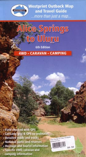
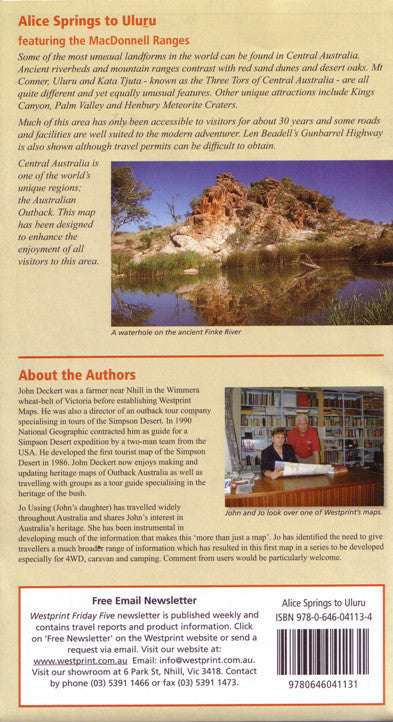
Alice Springs to Uluru Map Westprint
$13.95 $14.95
Afterpay is only available for orders between $50.00 and $1000.00 More info
Your Essential Navigation Guide to Australia’s Red Centre
Embark on one of Australia’s most iconic journeys with the Alice Springs to Uluru Map by Westprint, a richly detailed and highly practical map designed for explorers, road trippers, 4WD enthusiasts, and anyone captivated by the wonders of the outback.
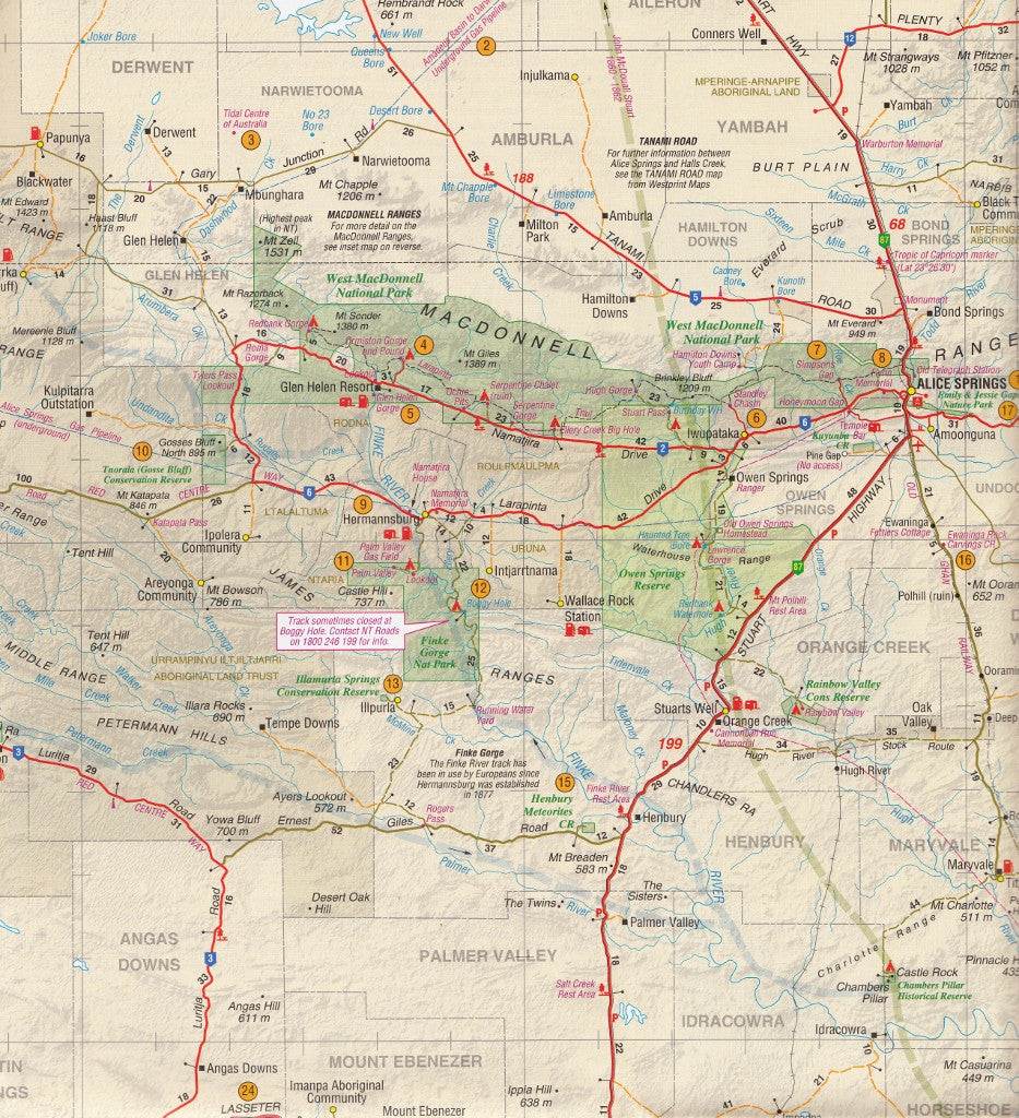
Whether you’re tracing the Stuart Highway, discovering the gorges of the West MacDonnell Ranges, or heading towards the sacred monolith of Uluru, this map offers comprehensive coverage, up-to-date road and track information, and a wealth of touring content to guide your adventure.
🧭 Key Map Features:
-
✅ Detailed Coverage of Central Australia
From Alice Springs to Uluru-Kata Tjuta National Park, including Kings Canyon, Glen Helen, Finke Gorge, and Hermannsburg. -
🏞️ Natural Features Highlighted
Includes the MacDonnell Ranges, Palm Valley, Mount Sonder, and the famed Lasseter’s Lost Reef, making it ideal for nature lovers and history buffs alike. -
🚙 Road and Track Classifications
Clearly marked sealed, unsealed, and 4WD tracks, including the Mereenie Loop Road, Larapinta Drive, Red Centre Way, and access to remote areas. -
⛺ Camping & Caravan Facilities
Features icons for campgrounds, caravan parks, rest stops, and roadhouses, ideal for those planning overnight stays. -
🧭 Heritage, Historic, and Tourist Info
Discover local legends, cultural sites, and lesser-known attractions with informative notes and GPS waypoints included throughout. -
📍 Inset Maps & GPS Coordinates
Contains inset detail maps for major sites and a comprehensive GPS waypoint list (Lat/Long), useful for GPS navigation and trip logging.
🏕️ Perfect For:
-
Travellers driving from Alice Springs to Uluru, with side trips to Kings Canyon, West MacDonnell Ranges, or Rainbow Valley
-
Adventurers exploring remote 4WD tracks and national parks
-
Cultural travellers interested in Indigenous sites, rock art, and sacred landscapes
-
Campers and caravanners seeking overnight sites, petrol stations, and key amenities in remote areas
-
Educational, geological, and historical explorers wanting to delve into the rich layers of Central Australia’s past
📘 Product Specifications
| Specification | Detail |
|---|---|
| Title | Alice Springs to Uluru Map |
| Publisher | Westprint Heritage Maps |
| Scale | 1:1,000,000 |
| Map Type | Folded Map |
| Size | Large format (suitable for dashboard use) |
| Printed Features | Roads, tracks, reserves, tourist info, GPS waypoints |
| Edition | Latest available |
| Made in | Australia |
🧭 Explore the Red Centre with confidence and clarity.
From the timeless silhouette of Uluru at sunrise to the winding tracks of the MacDonnell Ranges, this map is more than just a travel aid — it’s an invitation to immerse yourself in one of the world’s most extraordinary landscapes.
Whether you’re a seasoned 4WD adventurer or planning your first big lap through Australia’s centre, the Westprint Alice Springs to Uluru Map is a must-have tool for safe, informed, and unforgettable travel.


