- Australia ▾
- Topographic
▾
- Australia AUSTopo 250k (2024)
- Australia 50k Geoscience maps
- Australia 100k Geoscience maps
- Australia 250k Geoscience maps
- Australia 1.1m Geoscience maps
- New Zealand 50k maps
- New Zealand 250k maps
- New South Wales 25k maps
- New South Wales 50k maps
- New South Wales 100k maps
- Queensland 10k maps
- Queensland 25k maps
- Queensland 50k maps
- Queensland 100k maps
- Compasses
- Software
- GPS Systems
- Orienteering
- International ▾
- Wall Maps
▾
- World
- Australia & New Zealand
- Countries, Continents & Regions
- Historical
- Vintage National Geographic
- Australian Capital Territory
- New South Wales
- Northern Territory
- Queensland
- South Australia
- Tasmania
- Victoria
- Western Australia
- Celestial
- Children's
- Mining & Resources
- Wine Maps
- Healthcare
- Postcode Maps
- Electoral Maps
- Nautical ▾
- Flags
▾
- Australian Flag Sets & Banners
- Flag Bunting
- Handwavers
- Australian National Flags
- Aboriginal Flags
- Torres Strait Islander Flags
- International Flags
- Flagpoles & Accessories
- Australian Capital Territory Flags
- New South Wales Flags
- Northern Territory Flags
- Queensland Flags
- South Australia Flags
- Tasmania Flags
- Victoria Flags
- Western Australia Flags
- Gifts ▾
- Globes ▾
Dear valued customer. Please note that our checkout is not supported by old browsers. Please use a recent browser to access all checkout capabilities


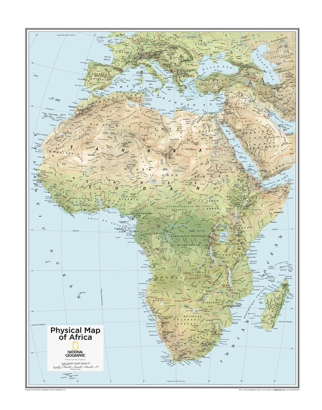
Africa Physical National Geographic 559 X 711mm Wall Map
$49.95
Afterpay is only available for orders between $50.00 and $1000.00 More info
🌍 Africa Physical Wall Map – National Geographic
559 x 711mm | Detailed Terrain | Premium Display Options
This detailed National Geographic Physical Wall Map of Africa offers a comprehensive view of the continent's diverse terrain. Featuring vibrant colour gradients and shaded relief, the map clearly highlights key features such as deserts and tropical forests, making it an essential resource for understanding Africa’s vast and varied landscape. Perfect for educational purposes, home decor, or as a reference tool, this map brings Africa’s unique geography to life in stunning detail.
🗺️ Key Features of the Africa Physical Wall Map
-
Detailed Geographic Coverage:
The map provides a detailed look at Africa’s physical geography, highlighting key landforms, including deserts, rainforests, mountain ranges, lakes, and rivers. From the Sahara Desert to the Congo Basin, it offers a clear visual representation of the continent’s diverse landscapes. -
Shaded Relief & Elevation:
Shaded relief is used to highlight Africa’s mountain ranges and elevations, making it easy to identify notable landforms such as the Atlas Mountains, Mount Kilimanjaro, and the Great Rift Valley. -
Tropical Forest & Desert Areas:
The map clearly delineates Africa’s tropical forests and desert regions, offering insight into the continent’s climatic zones and ecological diversity. -
Major Geographic Features:
Includes major rivers like the Nile, Congo, and Zambezi, as well as large lakes such as Lake Victoria and Lake Tanganyika, allowing for a comprehensive understanding of the continent’s hydrology.
📌 Why You’ll Love This Map
-
✔️ Educational & Informative:
Perfect for students, educators, and geography enthusiasts, this map offers a detailed view of Africa’s geography and environmental features, making it an invaluable tool for learning. -
✔️ Durable & Long-Lasting:
Available in a range of finishes, the map is designed to withstand long-term use, whether it’s displayed in a high-traffic area or a classroom. -
✔️ Visually Stunning:
The shaded relief and vivid colours bring the physical features of Africa to life, making this map a beautiful addition to any room. -
✔️ Ideal for Decor & Study:
Whether you want to decorate your living room, office, or classroom, this map will add both educational value and aesthetic appeal to your space.
🖼️ Premium Finishing Options
Choose the perfect finish for your map based on style, durability, and functionality:
| Format | Description |
|---|---|
| 📜 Paper (160 gsm) | Printed on heavyweight matte-coated paper—ideal for framing under glass. A clean, traditional, and professional look. |
| 🧼 Laminated (Encapsulated) | Fully sealed in 80-micron gloss laminate for durability and easy cleaning—ideal for high-traffic spaces or classrooms. |
| 🪵 Laminated with Wooden Hang Rails | Laminated version mounted with natural timber rails (top and bottom) and a sturdy hanging cord. Ready to hang immediately. |
| 🖼️ Canvas (395 gsm) | Printed on HP Professional Matte Canvas with pigment-based inks. Fade-resistant, richly textured, and archival quality. |
| 🪵 Canvas with Wooden Hang Rails | Elegant canvas mounted with lacquered timber rails and hanging cord—perfect for a sophisticated, gallery-quality display. |
🔨 Note: Please allow up to 10 working days for delivery of hang-railed maps, as each is carefully mounted by our expert framer.
📐 Specifications
| Feature | Detail |
|---|---|
| Title | Africa Physical Wall Map – National Geographic |
| Map Type | Physical / Topographic |
| Dimensions | 559 mm (W) x 711 mm (H) |
| Material Options | Paper, Laminated, Canvas, With or Without Timber Rails |
| Made In | Australia |
🎁 A Unique Gift For…
-
🌍 Geography & Cartography Enthusiasts: Ideal for those passionate about African geography and the continent’s natural landscapes.
-
🌍 Teachers & Educators: A fantastic tool for classrooms, study spaces, or libraries focused on geography, climate, and environmental science.
-
🌍 Travel & Culture Lovers: Perfect for those with a love for Africa’s diverse landscapes, culture, and ecology, or anyone planning to explore the continent.
-
🌍 Home & Office Decor: Adds a beautiful, educational touch to any living room, office, or study.
🚚 Delivery & Framing Notes
-
Paper, Laminated, and Canvas (rolled) maps: Ships within 1–2 business days.
-
Hang-railed maps: Made to order—please allow up to 10 working days for production.
-
All maps are shipped securely in protective packaging to ensure safe delivery.
🌍 Discover the Diverse Terrain of Africa
This National Geographic map of Africa provides a stunning and educational look at the continent’s landforms, ecosystems, and geography. Whether you're using it for educational purposes, travel planning, or simply as a striking decorative piece, this map will remain an informative and beautiful addition to your space.
👉 Order yours today and explore the fascinating geography of Africa!


