- Australia ▾
- Topographic
▾
- Australia AUSTopo 250k (2025)
- Australia 50k Geoscience maps
- Australia 100k Geoscience maps
- Australia 250k Geoscience maps
- Australia 1:1m Geoscience maps
- New Zealand 50k maps
- New Zealand 250k maps
- New South Wales 25k maps
- New South Wales 50k maps
- New South Wales 100k maps
- Queensland 10k maps
- Queensland 25k maps
- Queensland 50k maps
- Queensland 100k maps
- Compasses
- Software
- GPS Systems
- Orienteering
- International ▾
- Wall Maps
▾
- World
- Australia & New Zealand
- Countries, Continents & Regions
- Historical
- Vintage National Geographic
- Australian Capital Territory
- New South Wales
- Northern Territory
- Queensland
- South Australia
- Tasmania
- Victoria
- Western Australia
- Celestial
- Children's
- Mining & Resources
- Wine Maps
- Healthcare
- Postcode Maps
- Electoral Maps
- Nautical ▾
- Flags
▾
- Australian Flag Sets & Banners
- Flag Bunting
- Handwavers
- Australian National Flags
- Aboriginal Flags
- Torres Strait Islander Flags
- International Flags
- Flagpoles & Accessories
- Australian Capital Territory Flags
- New South Wales Flags
- Northern Territory Flags
- Queensland Flags
- South Australia Flags
- Tasmania Flags
- Victoria Flags
- Western Australia Flags
- Gifts ▾
- Globes ▾
Dear valued customer. Please note that our checkout is not supported by old browsers. Please use a recent browser to access all checkout capabilities
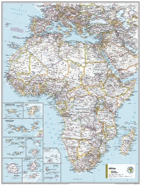
Africa Political - Atlas of the World, 11th Edition, National Geographic Wall Map
$69.95
or make 4 interest-free payments of
$17.49 AUD
fortnightly with
![]() More info
More info
🌍 Africa Political Wall Map
National Geographic | Atlas of the World, 11th Edition
Available Sizes: Standard (790 x 610 mm) | Supermap (915 x 1197 mm)
A clear, colourful portrait of a continent defined by culture, nations, and change.
This beautifully detailed Africa Political Wall Map, extracted from National Geographic’s 11th Edition Atlas of the World, brings Africa’s complex political landscape to life. Designed with educational clarity and visual impact in mind, it’s ideal for classrooms, libraries, offices, and anyone with a passion for understanding the modern map of Africa.
Every country is carefully distinguished by colour, every capital marked, and every major city and geographic boundary presented with the signature precision of National Geographic cartographers.
🗺️ What You’ll See on the Map
This political map focuses on nations, borders, and human geography while maintaining legibility and visual elegance:
-
🗺️ All 54 African nations clearly colour-coded for easy recognition
-
🏙️ Capital cities, major urban centres, and administrative boundaries
-
🌐 International borders and disputed territories, marked with clarity
-
💧 Major rivers and lakes included for reference and geographic orientation
-
📏 Azimuthal Equidistant Projection – ensuring distances are proportional from the map’s centre
-
✨ Clean, modern design for quick comprehension and visual appeal
An ideal tool for teaching African politics, history, and geography—or simply appreciating the diversity of a dynamic continent.
🖼️ Available Sizes & Formats
Choose the size and finish that suits your space and purpose:
| Size | Dimensions | Best For |
|---|---|---|
| Standard | 790 x 610 mm | Smaller study spaces, desks, or framed displays |
| Supermap | 915 x 1197 mm | Larger walls, classrooms, or conference rooms |
✨ Premium Format Options
| Format | Material & Finish | Recommended Use |
|---|---|---|
| Paper | 160gsm heavyweight matte paper | Framing under glass or Perspex |
| Laminated | True encapsulated 80-micron gloss lamination (both sides) – waterproof and whiteboard compatible | Classrooms, educational use, or travel planning |
| Canvas | Printed on 395gsm HP Matte Canvas using pigment inks – textured, durable, fade-resistant | Stylish, long-lasting wall décor |
➕ Optional wooden hang rails available for laminated and canvas formats to elevate your display.
🪵 Add Timber Hang Rails (Optional)
Upgrade your map into a ready-to-hang centrepiece:
-
🪵 Natural wood rails, lacquered in a smooth satin finish
-
🧵 Top rail includes a hanging cord for quick installation
-
🖐️ Professionally assembled by our framer
-
⏳ Please allow 10 working days for delivery of hang-railed versions
Bring structure and elegance to your map with a timeless wooden finish.
📐 Specifications
| Feature | Details |
|---|---|
| Title | Africa Political Wall Map |
| Publisher | National Geographic |
| Edition | Atlas of the World, 11th Edition |
| Projection | Azimuthal Equidistant |
| Map Type | Political – with select physical references |
| Standard Size | 790 x 610 mm |
| Supermap Size | 915 x 1197 mm |
| Origin | Printed and finished in Australia |
| Optional Extras | Timber hang rails (Laminated & Canvas formats) |
💡 Why Choose This Map?
🌍 A Modern Overview of Africa – Stay informed with current international boundaries and capitals.
🎓 Perfect for Classrooms – Teach geography, history, and politics with a clear, colourful visual aid.
🏡 Sophisticated Décor – A stunning addition to study walls, libraries, or office boardrooms.
🎁 A Thoughtful Gift – Ideal for educators, students, travellers, or map enthusiasts.
🖨️ Exceptional Print Quality – Printed in Australia using fade-resistant pigment inks and archival materials.
Let the Africa Political Wall Map provide a clear, commanding view of a continent in motion—its borders, its cities, and its global significance, rendered with unmistakable National Geographic style.
📦 Shipping Information
-
📄 Paper & Laminated maps: Ships in 1–2 business days
-
🖼️ Canvas or Timber Rail versions: Please allow 7–10 business days for finishing and dispatch
🛒 Add to Cart – Understand Africa at a Glance
Whether for education, decoration, or inspiration, this map brings the political face of Africa to your wall with clarity, colour, and authority.


