- Australia ▾
- Topographic
▾
- Australia AUSTopo 250k (2024)
- Australia 50k Geoscience maps
- Australia 100k Geoscience maps
- Australia 250k Geoscience maps
- Australia 1.1m Geoscience maps
- New Zealand 50k maps
- New Zealand 250k maps
- New South Wales 25k maps
- New South Wales 50k maps
- New South Wales 100k maps
- Queensland 10k maps
- Queensland 25k maps
- Queensland 50k maps
- Queensland 100k maps
- Compasses
- Software
- GPS Systems
- Orienteering
- International ▾
- Wall Maps
▾
- World
- Australia & New Zealand
- Countries, Continents & Regions
- Historical
- Vintage National Geographic
- Australian Capital Territory
- New South Wales
- Northern Territory
- Queensland
- South Australia
- Tasmania
- Victoria
- Western Australia
- Celestial
- Children's
- Mining & Resources
- Wine Maps
- Healthcare
- Postcode Maps
- Electoral Maps
- Nautical ▾
- Flags
▾
- Australian Flag Sets & Banners
- Flag Bunting
- Handwavers
- Australian National Flags
- Aboriginal Flags
- Torres Strait Islander Flags
- International Flags
- Flagpoles & Accessories
- Australian Capital Territory Flags
- New South Wales Flags
- Northern Territory Flags
- Queensland Flags
- South Australia Flags
- Tasmania Flags
- Victoria Flags
- Western Australia Flags
- Gifts ▾
- Globes ▾
Dear valued customer. Please note that our checkout is not supported by old browsers. Please use a recent browser to access all checkout capabilities


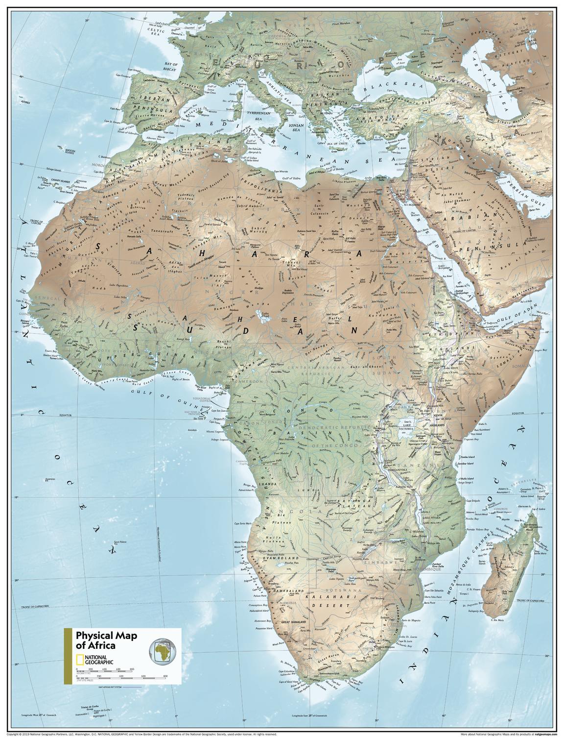
Africa Physical - Atlas of the World, 11th Edition, National Geographic Wall Map
$69.95
or make 4 interest-free payments of
$17.49 AUD
fortnightly with
![]() More info
More info
🌍 Africa Physical Wall Map
National Geographic | Atlas of the World, 11th Edition
Available Sizes: Standard (790 x 610 mm) & Supermap (915 x 1197 mm)
Experience the natural grandeur of Africa through stunning physical geography.
Breathtakingly detailed and beautifully designed, this Africa Physical Wall Map from National Geographic’s 11th Edition Atlas of the World brings the continent’s diverse landscapes vividly to life. From vast deserts and soaring highlands to lush river systems and jagged coastlines, this map showcases Africa as it truly appears—untamed, dramatic, and awe-inspiring.
Crafted using state-of-the-art cartographic techniques and printed to National Geographic’s legendary standards, this map is ideal for both educational environments and elegant wall displays.
🗺️ Physical Geography Features
Designed for clarity and educational value, this physical map includes:
-
🏔️ Shaded relief showing mountain ranges, valleys, and plateaus in dramatic 3D
-
💧 Rivers, lakes, and coastal features clearly labelled and rendered with precision
-
🏜️ Deserts, wetlands, and varied terrain types expressed through intuitive colours and textures
-
🌊 Bright blue oceans with bathymetric shading to suggest underwater relief
-
🌐 International borders, cities, and place names placed with legibility and balance
-
🧭 Azimuthal Equidistant Projection – ensures accurate proportional distances from the map’s centre point
-
📚 Featured in the National Geographic Atlas of the World, 11th Edition
A true-to-nature visualisation of Africa’s physical features—ideal for exploration, education, and inspiration.
🖼️ Available Sizes & Formats
Choose the size and format that suits your space:
| Size | Dimensions | Best For |
|---|---|---|
| Standard | 790 x 610 mm | Smaller classrooms, study nooks, or framed wall displays |
| Supermap | 915 x 1197 mm | Large spaces, lecture rooms, libraries, or offices |
✨ Premium Material Options
| Format | Material & Finish | Ideal Use |
|---|---|---|
| Paper | Printed on heavyweight 160gsm matte paper | For framing under glass or displaying in a protected frame |
| Laminated | Fully encapsulated in 80-micron gloss laminate (both sides) – waterproof and whiteboard marker compatible | Classrooms, planning areas, travel tracking |
| Canvas | Printed on 395gsm HP Matte Artist’s Canvas using pigment-based inks | Gallery-style finish, fade-resistant, and long-lasting |
➕ Optional timber hang rails available for laminated and canvas versions.
🪵 Timber Hang Rails (Optional Upgrade)
Give your map the finishing touch it deserves:
-
🪚 Handcrafted natural timber with satin lacquer finish
-
🧵 Corded top rail for effortless wall hanging
-
🖐️ Professionally assembled by our in-house framer
-
⏳ Please allow up to 10 working days for delivery of rail-mounted maps
From classroom to boardroom, your map becomes a centrepiece.
📐 Specifications Summary
| Feature | Details |
|---|---|
| Title | Africa Physical Wall Map |
| Publisher | National Geographic |
| Projection | Azimuthal Equidistant |
| Style | Physical – with shaded relief & geographic labelling |
| Origin | From the Atlas of the World, 11th Edition |
| Standard Size | 790 x 610 mm |
| Supermap Size | 915 x 1197 mm |
| Optional Extras | Timber hang rails (Laminated & Canvas formats only) |
| Print Origin | Printed and finished in Australia |
💡 Why Choose This Map?
🎓 A Classroom Essential – Perfect for teaching geography, climate, and environmental systems.
🌍 Explore Africa Naturally – Learn how rivers, mountain chains, deserts, and wetlands shape the continent.
🖼️ Striking Decorative Impact – Add substance and style to your space with a map that’s as beautiful as it is informative.
🎁 An Inspiring Gift – Ideal for educators, geographers, students, or anyone who loves learning about the world.
🖨️ Archival Print Quality – Crisp, fade-resistant pigment inks for long-lasting clarity and colour.
Let the Africa Physical Wall Map become a daily source of discovery—revealing the natural majesty of a continent that continues to shape our world.
📦 Shipping Information
-
📄 Paper & Laminated formats: Ships in 1–2 business days
-
🖼️ Canvas or Hang Rail versions: Please allow 7–10 business days for custom finishing and dispatch
🛒 Order Now – Bring Africa’s Landscape to Life
Choose your size, select your format, and elevate your space with this stunning cartographic showcase of Africa.


