- Australia ▾
- Topographic
▾
- Australia AUSTopo 250k (2024)
- Australia 50k Geoscience maps
- Australia 100k Geoscience maps
- Australia 250k Geoscience maps
- Australia 1.1m Geoscience maps
- New Zealand 50k maps
- New Zealand 250k maps
- New South Wales 25k maps
- New South Wales 50k maps
- New South Wales 100k maps
- Queensland 10k maps
- Queensland 25k maps
- Queensland 50k maps
- Queensland 100k maps
- Compasses
- Software
- GPS Systems
- Orienteering
- International ▾
- Wall Maps
▾
- World
- Australia & New Zealand
- Countries, Continents & Regions
- Historical
- Vintage National Geographic
- Australian Capital Territory
- New South Wales
- Northern Territory
- Queensland
- South Australia
- Tasmania
- Victoria
- Western Australia
- Celestial
- Children's
- Mining & Resources
- Wine Maps
- Healthcare
- Postcode Maps
- Electoral Maps
- Nautical ▾
- Flags
▾
- Australian Flag Sets & Banners
- Flag Bunting
- Handwavers
- Australian National Flags
- Aboriginal Flags
- Torres Strait Islander Flags
- International Flags
- Flagpoles & Accessories
- Australian Capital Territory Flags
- New South Wales Flags
- Northern Territory Flags
- Queensland Flags
- South Australia Flags
- Tasmania Flags
- Victoria Flags
- Western Australia Flags
- Gifts ▾
- Globes ▾
Dear valued customer. Please note that our checkout is not supported by old browsers. Please use a recent browser to access all checkout capabilities


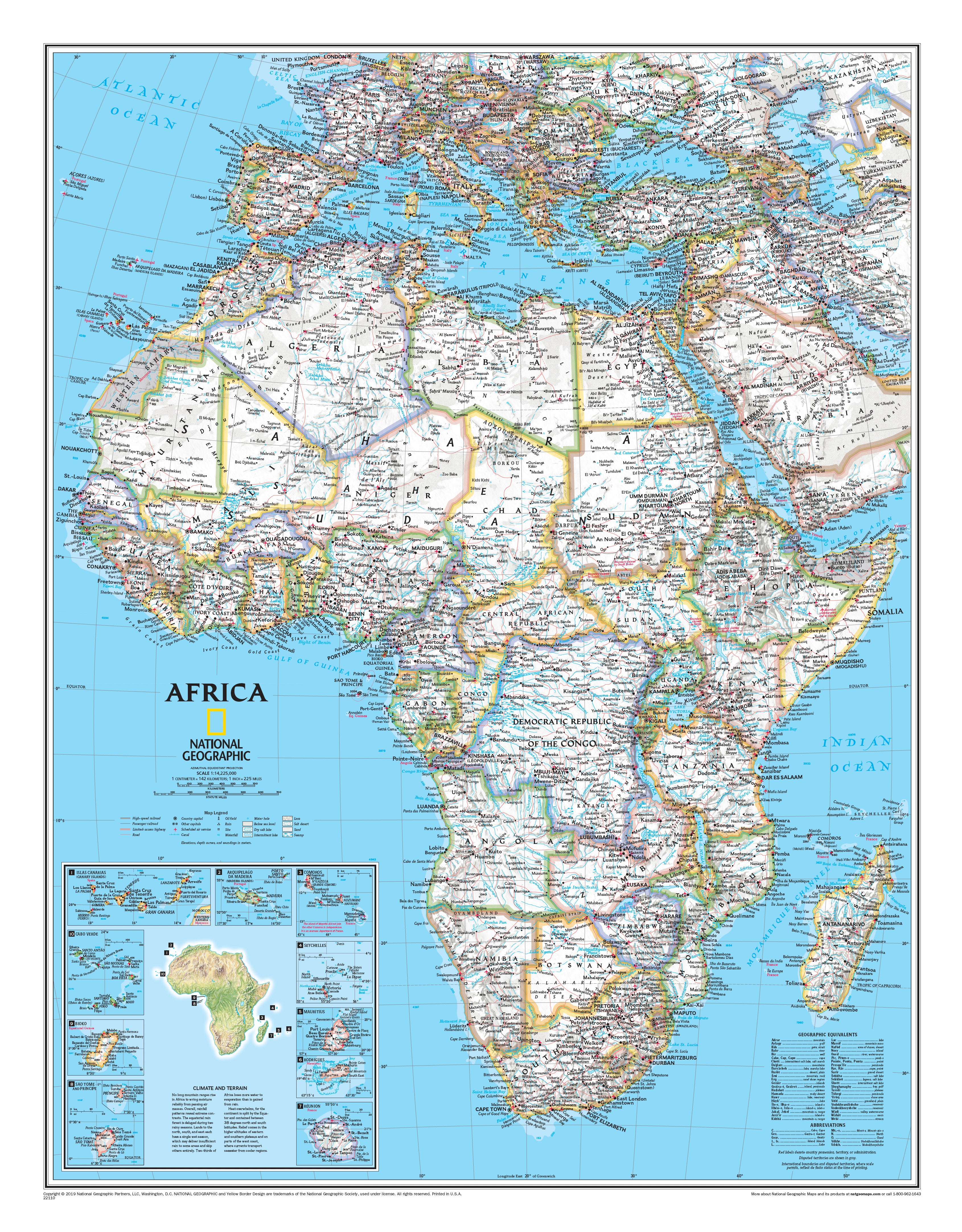
Africa National Geographic 610 x 780mm Wall Map
$59.95
or make 4 interest-free payments of
$14.99 AUD
fortnightly with
![]() More info
More info
National Geographic's map of Africa is as attractive as it is functional. The entire continent is rendered in the Classic style with colourful, clearly defined international borders, shaded relief, and easy-to-read fonts. Place names, bodies of water, airports, major highways and roads, and cartographic patterns are also shown to depict sand, lava fields, swamps, dry salt lakes, intermittent lakes, salt deserts, and areas below sea level. This map also includes an informative inset on climate and terrain, a topographic map of the continent, and individual insets of the 10 island nations surrounding Africa.
The map can be printed on heavyweight 160 gsm paper or laminated. The paper version is perfect for framing under glass, and the laminated version is exceptionally hard-wearing, as we use a true encapsulation of two pieces of 80-micron gloss laminate.
Alternatively, we can supply this map on 395 gsm HP Professional Matte Canvas using pigment-based inks, making it highly durable and fade-resistant. The exceptional clarity of the printing makes this map a stunning addition to any room, and its high quality means that it will provide years of enjoyment.
The easiest way to hang your canvas map is by having wooden hang rollers attached to the top and bottom with a hanging cord on the top roller, so all you have to do is put a hook in the wall. The hang rails come lacquered in a natural timber colour.
Note: Please allow 10 working days for delivery of hang-railed maps, as our framer needs to attach them.
Size: 610 mm (w) x 780 mm (h)
Made in Australia


