- Australia ▾
- Topographic
▾
- Australia AUSTopo 250k (2024)
- Australia 50k Geoscience maps
- Australia 100k Geoscience maps
- Australia 250k Geoscience maps
- Australia 1.1m Geoscience maps
- New Zealand 50k maps
- New Zealand 250k maps
- New South Wales 25k maps
- New South Wales 50k maps
- New South Wales 100k maps
- Queensland 10k maps
- Queensland 25k maps
- Queensland 50k maps
- Queensland 100k maps
- Compasses
- Software
- GPS Systems
- Orienteering
- International ▾
- Wall Maps
▾
- World
- Australia & New Zealand
- Countries, Continents & Regions
- Historical
- Vintage National Geographic
- Australian Capital Territory
- New South Wales
- Northern Territory
- Queensland
- South Australia
- Tasmania
- Victoria
- Western Australia
- Celestial
- Children's
- Mining & Resources
- Wine Maps
- Healthcare
- Postcode Maps
- Electoral Maps
- Nautical ▾
- Flags
▾
- Australian Flag Sets & Banners
- Flag Bunting
- Handwavers
- Australian National Flags
- Aboriginal Flags
- Torres Strait Islander Flags
- International Flags
- Flagpoles & Accessories
- Australian Capital Territory Flags
- New South Wales Flags
- Northern Territory Flags
- Queensland Flags
- South Australia Flags
- Tasmania Flags
- Victoria Flags
- Western Australia Flags
- Gifts ▾
- Globes ▾
Dear valued customer. Please note that our checkout is not supported by old browsers. Please use a recent browser to access all checkout capabilities
Afghanistan & Pakistan National Geographic 826 x 546mm Wall Map
$59.95
or make 4 interest-free payments of
$14.99 AUD
fortnightly with
![]() More info
More info
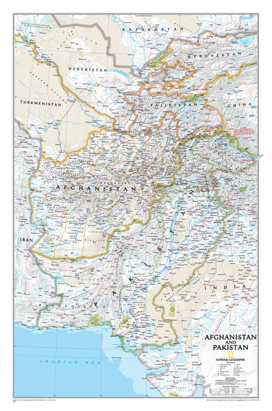
Step into the heart of Central and South Asia with this National Geographic Afghanistan & Pakistan Wall Map — one of the most detailed and authoritative maps ever created of the region. At once a work of art and a serious geographic reference, this map blends cartographic precision with striking visual clarity, offering a view of Afghanistan, Pakistan, and their neighbouring territories as only National Geographic can.
Whether you’re an educator, researcher, student, traveller, or collector, this wall map provides an indispensable lens into a region that has shaped world history and continues to influence global events.
🌍 A Window into a Complex and Historic Region
Few places on earth combine such a rich intersection of geography, politics, and culture as Afghanistan and Pakistan. This National Geographic wall map covers:
-
Afghanistan & Pakistan in full, highlighting their provinces, borders, towns, cities, and physical landscapes.
-
Neighbouring Nations including Tajikistan, and portions of Turkmenistan, Uzbekistan, Kyrgyzstan, China, India, and Iran, to provide essential regional context.
-
The disputed territory of Kashmir, with boundaries carefully delineated to reflect the region’s complex political situation.
National Geographic’s Classic cartographic style — clean fonts, vibrant colours, and shaded relief — makes the map both highly legible and visually engaging. It is ideal for both reference and display.
🗺️ Cartographic Excellence & Detail
As with all National Geographic maps, this piece is created with meticulous attention to accuracy and readability. Every feature has been carefully chosen to balance clarity with depth of information.
Key Features
-
Political Boundaries – International borders shown with precision, including disputed territories such as Kashmir.
-
Cities & Towns – Thousands of place names, from major capitals to smaller towns, ensuring no detail is overlooked.
-
Physical Features – Mountain ranges, glaciers, deserts, swamps, and areas of sand are marked with cartographic textures.
-
Infrastructure & Connectivity – Highways, roads, railways, canals, and airports are included, showing how people move across this vast and varied terrain.
-
Natural Resources – Oil fields, waterways, and salt lakes are identified, underlining the region’s environmental and economic importance.
-
Water & Relief – Shaded relief highlights the rugged terrain, while intermittent rivers and dry salt lakes provide an accurate environmental picture.
This map balances political accuracy, physical realism, and aesthetic clarity, a hallmark of National Geographic’s cartography for over a century.
🎨 Formats & Finishes
To suit a range of needs — from classrooms and offices to libraries and private collections — this wall map is available in multiple premium finishes:
-
Heavyweight Paper (160 gsm) – Crisp, detailed, and ideal for framing under glass.
-
Laminated (80 Micron Gloss Encapsulation) – A hard-wearing, wipe-clean finish that ensures durability. Perfect for frequent handling in classrooms, study spaces, or research settings.
-
Canvas (395 gsm HP Professional Matte Canvas) – A museum-grade option printed with pigment-based inks. Fade resistant and richly textured, this transforms the map into a work of art.
-
Canvas or Laminate with Wooden Hang Rails – Professionally mounted with natural timber rails, lacquered for a smooth finish, with a cord attached for effortless hanging.
-
(Please allow up to 10 working days for hang-railed maps, as each is custom-mounted by our framer.)
-
Each format offers a different way to enjoy this map, from practical use to decorative display.
📐 Specifications
| Feature | Details |
|---|---|
| Title | Afghanistan & Pakistan – National Geographic Wall Map |
| Publisher | National Geographic |
| Style | Classic (bright colour palette, shaded relief) |
| Size | 826 mm (high) × 546 mm (wide) |
| Scale | Detailed regional coverage |
| Finishes | Paper, Laminated, Canvas, Hang-Railed |
| Printing | Pigment-based inks, fade resistant |
| Made in | Australia |
🎯 Who Is This Map For?
This is more than a wall map — it is a resource, a conversation piece, and a work of cartographic art.
-
Educators & Students – Ideal for teaching regional geography, geopolitics, and cultural studies. Its level of detail supports both secondary and tertiary education.
-
Researchers & Analysts – A serious reference for those studying the region’s history, politics, or strategic importance.
-
Travellers & Explorers – For those fascinated by Central and South Asia, this map provides a clear and inspiring overview.
-
Collectors & Enthusiasts – A fine addition to any collection of National Geographic maps, blending educational value with aesthetic appeal.
-
Interior & Office Spaces – Its vibrant Classic design ensures it looks just as striking in a study, office, or library as it does in a classroom.
✨ Why Choose National Geographic?
National Geographic has been setting the gold standard for cartography for over 130 years. Every map combines:
-
Unparalleled Accuracy – Researched and produced by expert cartographers.
-
Distinctive Styling – The famous Classic style, with blue oceans and shaded relief, is instantly recognisable.
-
Educational Value – A tool for learning and discovery, designed for clarity and readability.
-
Decorative Elegance – Maps that are as beautiful as they are informative.
Owning a National Geographic wall map means investing in a piece of trusted geographic heritage.
🏆 A Statement Piece for Any Wall
Whether framed, laminated, or printed on museum-grade canvas, this map will command attention. It is equally at home in:
-
Academic Institutions – Geography, history, and international relations classrooms.
-
Libraries & Study Rooms – A valuable reference for researchers and enthusiasts alike.
-
Corporate & Government Offices – A sophisticated wall piece reflecting global awareness.
-
Home Décor – Adds cultural depth and intellectual interest to living rooms, studies, or private libraries.
📦 Delivery & Framing Notes
-
Standard paper, laminated, and canvas prints are shipped promptly.
-
For hang-railed maps, please allow up to 10 working days as these are custom-mounted by our professional framer.
-
Proudly made in Australia using premium materials and printing techniques.
🔑 Key Takeaway
The Afghanistan & Pakistan National Geographic Wall Map is more than just a map — it is a gateway to understanding one of the most important regions of the modern world. Combining National Geographic’s cartographic expertise with multiple premium finish options, it is a resource that will remain relevant, attractive, and enduring for years to come.
Bring this map into your space, and let it inspire curiosity, conversation, and exploration.


