- Australia ▾
- Topographic
▾
- Australia AUSTopo 250k (2025)
- Australia 50k Geoscience maps
- Australia 100k Geoscience maps
- Australia 250k Geoscience maps
- Australia 1:1m Geoscience maps
- New Zealand 50k maps
- New Zealand 250k maps
- New South Wales 25k maps
- New South Wales 50k maps
- New South Wales 100k maps
- Queensland 10k maps
- Queensland 25k maps
- Queensland 50k maps
- Queensland 100k maps
- Western Australia 25k maps
- Western Australia 50k maps
- Western Australia 100k maps
- Compasses
- Software
- GPS Systems
- International ▾
- Wall Maps
▾
- World
- Australia & New Zealand
- Countries, Continents & Regions
- Historical
- Vintage National Geographic
- Australian Capital Territory
- New South Wales
- Northern Territory
- Queensland
- South Australia
- Tasmania
- Victoria
- Western Australia
- Celestial
- Children's
- Mining & Resources
- Wine Maps
- Healthcare
- Postcode Maps
- Electoral Maps
- Nautical ▾
- Flags
▾
- Australian Flag Sets & Banners
- Flag Bunting
- Handwavers
- Australian National Flags
- Aboriginal Flags
- Torres Strait Islander Flags
- International Flags
- Flagpoles & Accessories
- Australian Capital Territory Flags
- New South Wales Flags
- Northern Territory Flags
- Queensland Flags
- South Australia Flags
- Tasmania Flags
- Victoria Flags
- Western Australia Flags
- Gifts ▾
- Globes ▾
Dear valued customer. Please note that our checkout is not supported by old browsers. Please use a recent browser to access all checkout capabilities


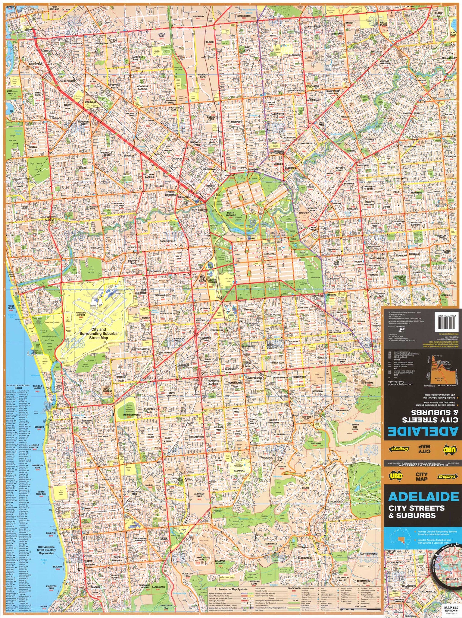
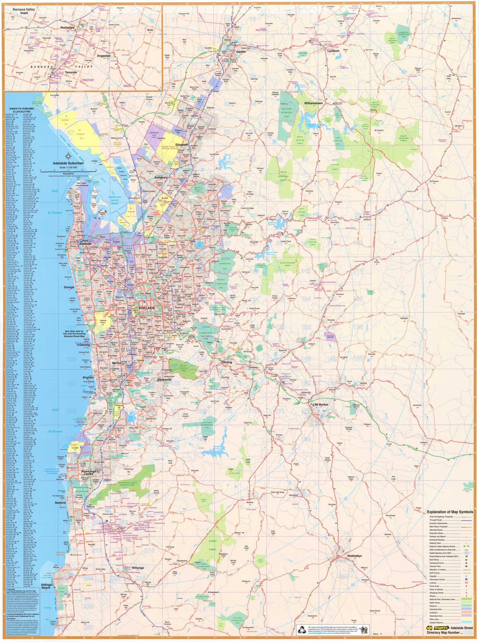
Adelaide City Streets & Suburbs UBD 562 Map
$13.95
Afterpay is only available for orders between $50.00 and $1000.00 More info
A Comprehensive, Laminated Reference Map for Home, Office, or Professional Use
The UBD Greater Adelaide Double-Sided Wall Map offers exceptional cartographic detail, practical suburb indexing, and attractive visual presentation. Whether you’re managing a logistics business, navigating residential suburbs, planning real estate investments, or simply curious about your city, this is the definitive map for understanding Adelaide’s complex urban fabric.
🏙️ Detailed Central Suburb Coverage (Front Side)
One side of the map offers street-level detail of Adelaide’s central metropolitan area, making it ideal for in-depth navigation and localised planning. This detailed coverage spans:
-
Northwest: Birkenhead
-
Northeast: Holden Hill
-
Southwest: Marino
-
Southeast: Coromandel East
This section features:
-
Precise street grids
-
Parks and green spaces
-
Residential zones
-
Local services and landmarks
-
Important infrastructure and transport corridors
Perfect for:
-
Real estate agents needing accurate suburb layouts
-
Local business owners planning delivery or service zones
-
Planners and designers working within council boundaries
🌆 Greater Metropolitan Adelaide & Barossa Valley (Reverse Side)
The reverse side offers an overview of Greater Adelaide, expanding outward to include a broader commuter and lifestyle region. The coverage stretches:
-
From Gawler in the north
-
Down to Aldinga Beach in the south
Also featured is a detailed inset of the Barossa Valley, one of Australia’s most celebrated wine and food regions.
Clearly presented features include:
-
Major and secondary roads
-
Arterial routes and bypasses
-
Industrial zones and commercial precincts
-
Suburban development patterns
-
National and conservation parks
-
Suburb names, complete with postcodes, all referenced in a detailed index
This side is perfect for high-level business planning, tourism marketing, and regional logistics.
🧾 Product Specifications
-
Scale:
-
Central Detail: 1:25,000
-
Greater Adelaide/Barossa: 1:100,000
-
-
Sheet Size: 700 mm (width) x 1000 mm (height)
-
Edition: Published 2023
-
Publisher: UBD Gregory’s
-
Printed in: Australia
🧰 Laminated Options for Every Budget
We offer two versions of the laminated map to suit different needs and price points:
🔹 Premium Flat Laminated Map – $99.00
Encapsulated between two sheets of 80-micron gloss laminate, this edition is:
-
✅ Durable and resistant to stains, moisture, and tearing
-
✅ Writable with whiteboard markers and reusable
-
✅ Compatible with Mark-It-Dots to highlight locations
-
✅ Ideal for framing, wall-mounting, or magnetic backing
Perfect for permanent wall display in:
-
Offices
-
Real estate agencies
-
Government departments
-
Classrooms and community hubs
🔹 Folded Laminated Map – $49.95
This more affordable option is created by laminating a previously folded map. It offers the same durability and usability but will retain some minor crease lines.
Excellent for:
-
Budget-conscious users
-
Short-term planning
-
Informal wall display or travel use
🖼️ Optional Add-On: Wooden Hanging Rails
Want a more elegant presentation? Add natural timber hanging rails (top and bottom) for a gallery-style finish. These rails include a hanging cord attached to the top rail, making installation as simple as placing a hook in the wall.
⏳ Please allow up to 10 working days for delivery if hang rails are selected, as this involves custom work by our framer.
📌 Why This Map Is a Must-Have
-
✅ Covers both micro and macro views of Adelaide and surrounds
-
✅ Ideal for business planning, urban development, travel, and general reference
-
✅ Clearly marked postcode zones and suburb names
-
✅ Features a beautiful Barossa Valley inset
-
✅ Printed on FSC-certified 120 gsm matte-coated paper using fade-resistant HP pigment inks
-
✅ Encapsulated in 80-micron gloss laminate for long-lasting use
-
✅ Made in Australia, supporting local cartography and print production
Frequently Asked Questions
Where can I buy the Adelaide City Streets & Suburbs UBD 562 Map?
The Adelaide City Streets & Suburbs UBD 562 Map is available to buy online from Mapworld, Australia's largest map and geographic product retailer, with fast shipping Australia-wide.
Is the Adelaide City Streets & Suburbs UBD 562 Map in stock at Mapworld?
Mapworld maintains extensive stock across its map range and aims for fast dispatch. Orders placed before 2pm AEST on business days are typically dispatched the same day, with standard and express Australia-wide delivery options available.
What is Mapworld's returns policy?
Mapworld accepts returns on undamaged items in original condition. Contact Mapworld within 90 days of purchase to arrange a return or exchange.
Does Mapworld ship the Adelaide City Streets & Suburbs UBD 562 Map across Australia?
Yes, Mapworld ships Australia-wide. Standard shipping is a flat $7 rate, with free standard shipping on orders over $75. Express options are available at checkout. Most orders placed before 2pm AEST on weekdays are dispatched same day.
Related Items


© 2026 Mapworld. Website designed by Genie Media
X