- Australia ▾
- Topographic
▾
- Australia AUSTopo 250k (2025)
- Australia 50k Geoscience maps
- Australia 100k Geoscience maps
- Australia 250k Geoscience maps
- Australia 1:1m Geoscience maps
- New Zealand 50k maps
- New Zealand 250k maps
- New South Wales 25k maps
- New South Wales 50k maps
- New South Wales 100k maps
- Queensland 10k maps
- Queensland 25k maps
- Queensland 50k maps
- Queensland 100k maps
- Compasses
- Software
- GPS Systems
- Orienteering
- International ▾
- Wall Maps
▾
- World
- Australia & New Zealand
- Countries, Continents & Regions
- Historical
- Vintage National Geographic
- Australian Capital Territory
- New South Wales
- Northern Territory
- Queensland
- South Australia
- Tasmania
- Victoria
- Western Australia
- Celestial
- Children's
- Mining & Resources
- Wine Maps
- Healthcare
- Postcode Maps
- Electoral Maps
- Nautical ▾
- Flags
▾
- Australian Flag Sets & Banners
- Flag Bunting
- Handwavers
- Australian National Flags
- Aboriginal Flags
- Torres Strait Islander Flags
- International Flags
- Flagpoles & Accessories
- Australian Capital Territory Flags
- New South Wales Flags
- Northern Territory Flags
- Queensland Flags
- South Australia Flags
- Tasmania Flags
- Victoria Flags
- Western Australia Flags
- Gifts ▾
- Globes ▾
Dear valued customer. Please note that our checkout is not supported by old browsers. Please use a recent browser to access all checkout capabilities


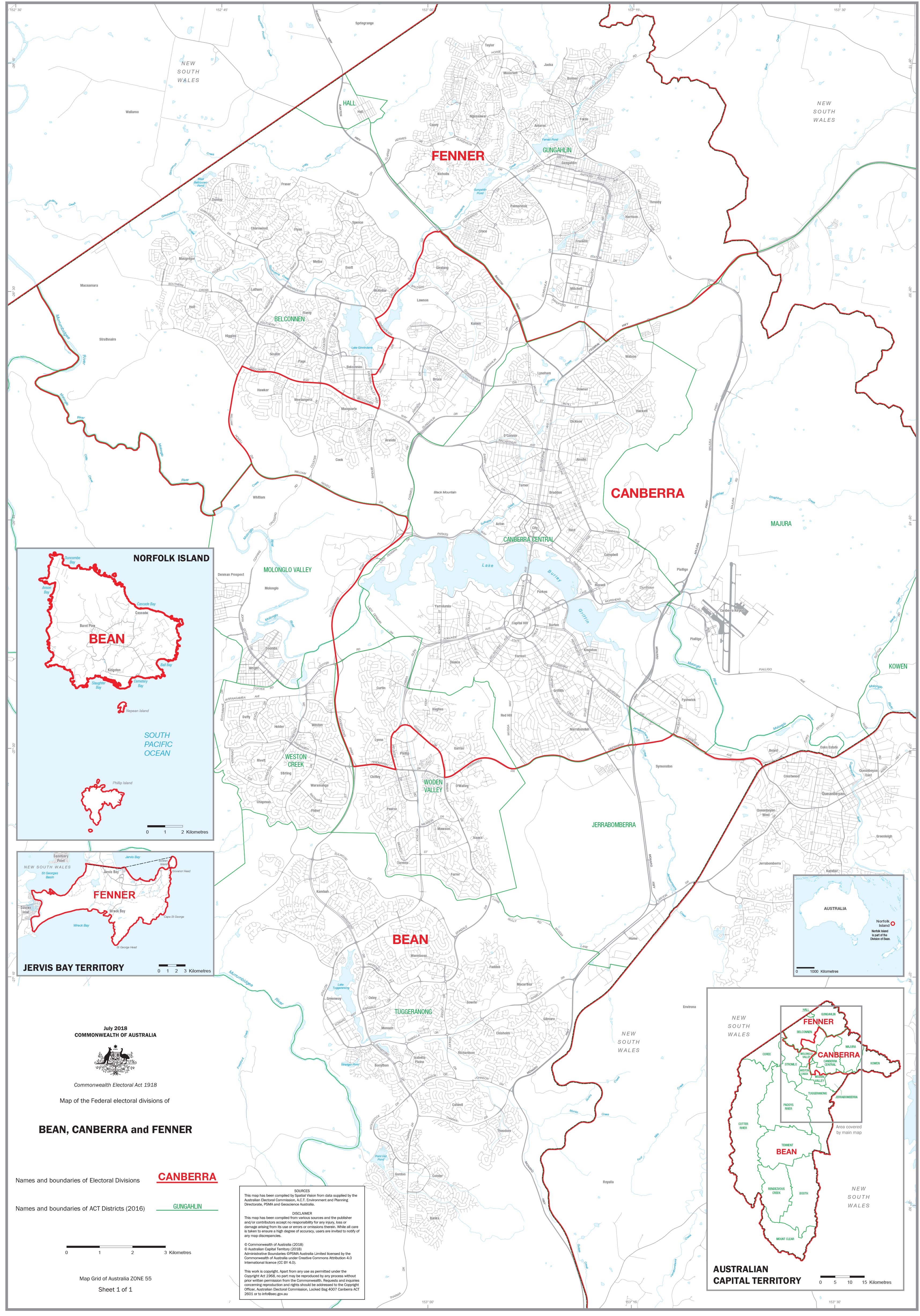
ACT Federal Electoral Divisions and Local Government Areas Map
$59.95
or make 4 interest-free payments of
$14.99 AUD
fortnightly with
![]() More info
More info
ACT Federal Electoral Divisions & Local Government Areas — Administrative Map
1000 × 700 mm • Paper / Laminated / Laminated + Hang Rails / Canvas / Canvas + Hang Rails • Printed in Australia
A clear, wall-readable reference of the Australian Capital Territory’s three federal electoral divisions—BEAN, CANBERRA, and FENNER—plus all ACT Local Government Areas (LGAs). Ideal for offices, classrooms, community spaces, and election operations.
🧭 At a Glance (What’s on the Map)
-
Federal divisions shown: BEAN, CANBERRA, FENNER (names & boundaries)
-
Local Government Areas: complete LGA names & boundaries across the ACT
-
Orientation aids: legend, scale bar, neatline, major features for quick reference
-
Wall-readable design: crisp boundary hierarchy and uncluttered labels
🎯 Why This Map Works
-
Dual-layer clarity — view federal divisions and LGAs together for efficient planning and communication
-
Planning-ready — perfect for election prep, community outreach, service coverage, and reporting
-
Professional finish — clean cartography that holds up in meeting rooms and public display
-
Durable options — laminate for daily annotation, or canvas for a premium wall feature
🧰 Customisation (On Request)
-
Individual Division Maps: Order detailed stand-alone maps of BEAN, CANBERRA, or FENNER
-
Branding & overlays: add logos, office locations, or service regions
-
Alternate sizes: scale to suit boardrooms or compact walls
🎨 Finishes & Display Options
-
📄 Paper — Heavyweight 160 gsm (Matte)
Smooth, low-glare stock ideal for framing under glass. -
💧 Laminated — True Encapsulation
Printed on 120 gsm and sealed in 2 × 80-micron gloss laminate (edge-sealed).
Wipe-clean • Tear-resistant • Moisture-safe — use non-permanent whiteboard markers and map dots. -
🪵 Laminated + Timber Hang Rails — Ready to Hang
Natural lacquered timber rails (top & bottom) with a top hanging cord for a frame-free, polished display.
Please allow up to 10 working days for rail fitting. -
🖼️ Canvas — HP 395 gsm Professional Matte
Gallery-grade canvas printed with pigment-based, fade-resistant inks for long-life colour. -
🪵 Canvas + Timber Hang Rails
Same premium canvas, finished with natural timber rails + top hanging cord.
Please allow up to 10 working days for rail fitting.
Dry-erase markers are recommended only on laminated versions.
📐 Specifications
| Attribute | Details |
|---|---|
| Title | ACT Federal Electoral Divisions & Local Government Areas — Administrative Map |
| Coverage | Australian Capital Territory (ACT), Australia |
| Content | Federal divisions (BEAN, CANBERRA, FENNER) + LGA names & boundaries |
| Map Type | Administrative (Federal Electoral + Local Government) |
| Size | 1000 mm (H) × 700 mm (W) |
| Formats | Paper • Laminated • Laminated + Hang Rails • Canvas • Canvas + Hang Rails |
| Paper | 160 gsm matte |
| Laminate | 2 × 80-micron gloss, true encapsulation (edge-sealed) |
| Canvas | HP 395 gsm Professional Matte |
| Inks | Pigment-based, fade-resistant |
| Origin | Printed in Australia |
| Lead Time | Hang-railed finishes: up to 10 working days |
🧽 Mounting & Care
-
Laminated: Use non-permanent whiteboard markers; wipe with a dry microfibre cloth (lightly damp if needed).
-
Paper: Frame under glass; avoid direct sunlight.
-
Canvas: Dust gently; avoid liquids and prolonged direct sunlight.
-
Hanging tip: For rail versions, use a centred wall hook and allow the map to hang naturally.
🤝 Our Commitment
-
Local craftsmanship: Designed, printed, and finished in Australia.
-
Premium materials: FSC-style papers, archival HP pigment inks, and HP 395 gsm Professional Matte Canvas for long service life.
-
Colour-managed output: Consistent, wall-readable cartography across your series.
-
Sustainable mindset: Durable finishes that extend product life and reduce waste.
-
Hand-checked & securely packed: Every map is inspected and boxed to arrive clean and display-ready.
Put the ACT’s federal divisions and LGAs on one clear, authoritative map.
Choose your finish and add to cart — or ask for an individual division map tailored to your needs.
Frequently Asked Questions
Where can I buy the ACT Federal Electoral Divisions and Local Government Areas Map?
The ACT Federal Electoral Divisions and Local Government Areas Map is available to buy online from Mapworld, Australia's largest map and geographic product retailer, with fast shipping Australia-wide.
Is the ACT Federal Electoral Divisions and Local Government Areas Map in stock at Mapworld?
Mapworld maintains extensive stock across its map range and aims for fast dispatch. Orders placed before 2pm AEST on business days are typically dispatched the same day, with standard and express Australia-wide delivery options available.
What is Mapworld's returns policy?
Mapworld accepts returns on undamaged items in original condition. Contact Mapworld within 30 days of purchase to arrange a return or exchange.
Does Mapworld ship the ACT Federal Electoral Divisions and Local Government Areas Map across Australia?
Yes, Mapworld ships Australia-wide. Standard shipping is a flat $7 rate, with free standard shipping on orders over $75. Express options are available at checkout. Most orders placed before 2pm AEST on weekdays are dispatched same day.


