- Australia ▾
- Topographic
▾
- Australia AUSTopo 250k (2025)
- Australia 50k Geoscience maps
- Australia 100k Geoscience maps
- Australia 250k Geoscience maps
- Australia 1:1m Geoscience maps
- New Zealand 50k maps
- New Zealand 250k maps
- New South Wales 25k maps
- New South Wales 50k maps
- New South Wales 100k maps
- Queensland 10k maps
- Queensland 25k maps
- Queensland 50k maps
- Queensland 100k maps
- Western Australia 25k maps
- Western Australia 50k maps
- Western Australia 100k maps
- Compasses
- Software
- GPS Systems
- International ▾
- Wall Maps
▾
- World
- Australia & New Zealand
- Countries, Continents & Regions
- Historical
- Vintage National Geographic
- Australian Capital Territory
- New South Wales
- Northern Territory
- Queensland
- South Australia
- Tasmania
- Victoria
- Western Australia
- Celestial
- Children's
- Mining & Resources
- Wine Maps
- Healthcare
- Postcode Maps
- Electoral Maps
- Nautical ▾
- Flags
▾
- Australian Flag Sets & Banners
- Flag Bunting
- Handwavers
- Australian National Flags
- Aboriginal Flags
- Torres Strait Islander Flags
- International Flags
- Flagpoles & Accessories
- Australian Capital Territory Flags
- New South Wales Flags
- Northern Territory Flags
- Queensland Flags
- South Australia Flags
- Tasmania Flags
- Victoria Flags
- Western Australia Flags
- Gifts ▾
- Globes ▾
Dear valued customer. Please note that our checkout is not supported by old browsers. Please use a recent browser to access all checkout capabilities


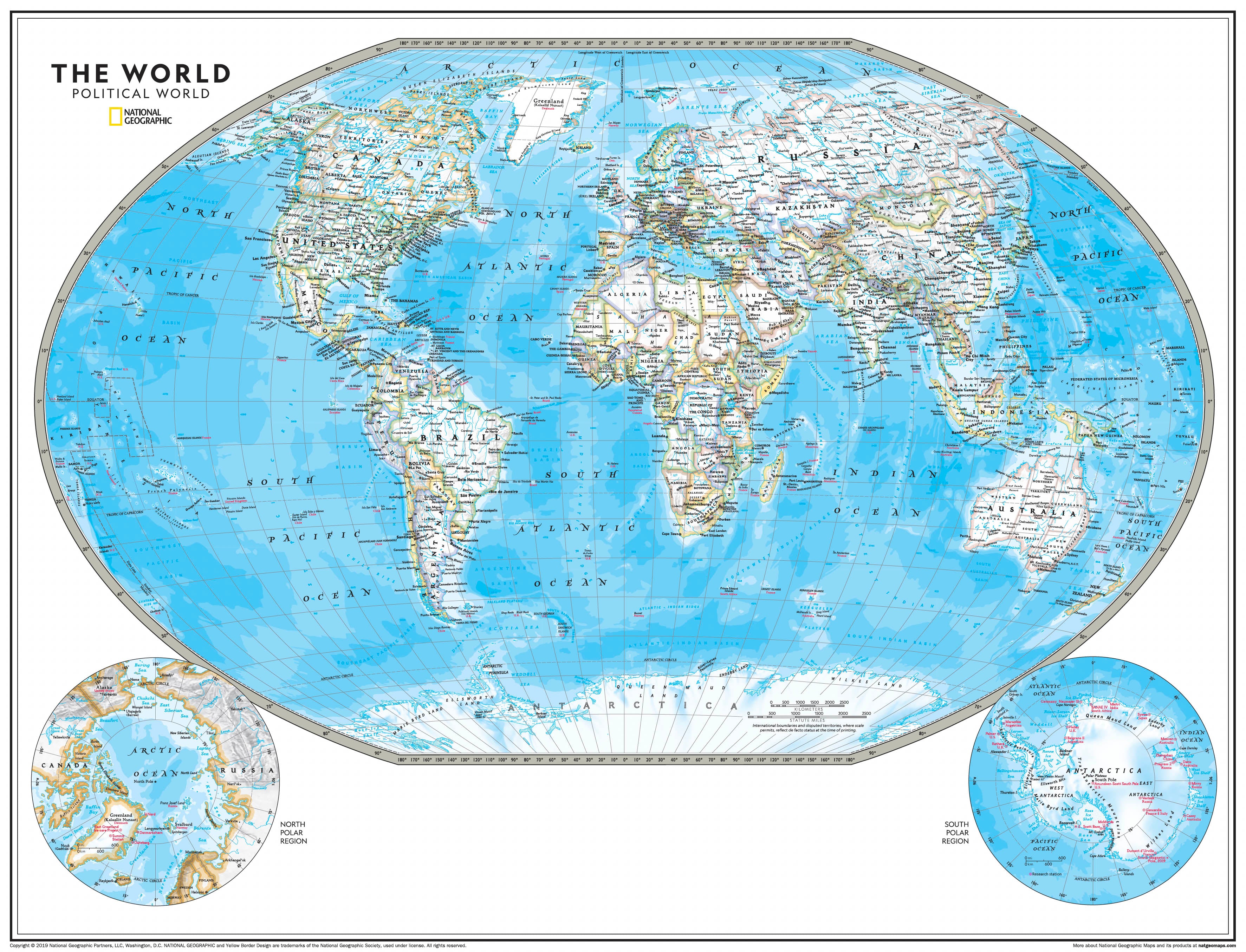
Political World Map - Atlas of the World 798 x 610mm Wall Map
$59.95
or make 4 interest-free payments of
$14.99 AUD
fortnightly with
![]() More info
More info
🌍 Political World Map – Atlas of the World
Dimensions: 798 mm (W) × 610 mm (H) | Scale: 1:53,145,000
Projection: Winkel Tripel | Finishes: Paper, Laminated, Canvas | Optional: Timber Hang Rails
Made in Australia
🗺 A Clear View of Our Political World
Featured in the National Geographic Atlas of the World, 11th Edition, this Political World Map is the definitive wall reference for understanding the nations, regions, and borders of our planet. Combining state-of-the-art cartography with National Geographic’s hallmark design, it presents an authoritative and visually engaging view of the political landscape—perfect for classrooms, offices, libraries, and travel enthusiasts.
With crisp boundary lines, shaded relief, and deep blue oceans, this map manages to be both richly informative and strikingly beautiful.
📌 Key Features
Trusted National Geographic Cartography
-
Based on decades of geographic research and independent editorial standards.
-
Uses the Winkel Tripel projection to minimise distortion, ensuring Greenland is shown at its true scale compared to other landmasses.
Political & Physical Detail Combined
-
Clearly defined international boundaries with bold die lines.
-
White and colour-filled interiors for easy reading of place names.
-
Physical elements such as mountain ranges, rivers, and ocean bathymetry for extra depth.
Thousands of Place Names
-
Carefully placed for legibility, even in densely populated regions like Europe, Asia, and the Middle East.
-
Includes major cities, capitals, key rivers, and important geographic landmarks.
Polar Insets
-
Corner inset maps detail Arctic and Antarctic regions.
-
Ideal for teaching about polar geography and environmental change.
🖼 Premium Finish Options
📄 160 gsm Archival Paper
-
Smooth matte finish.
-
Perfect for framing under glass.
-
Crisp, colour-accurate printing.
💧 Encapsulated Gloss Laminate (80 Micron Front & Back)
-
Waterproof, UV-protected, and wipe-clean.
-
Tear-resistant and ideal for classrooms or offices.
-
Suitable for use with whiteboard markers.
🎨 395 gsm HP Professional Matte Canvas
-
Printed with archival pigment-based inks for vivid colour and fade resistance.
-
Rich texture and gallery-quality clarity.
-
Long-lasting, durable, and perfect for display.
🪵 Optional Timber Hang Rails – Professional & Practical
-
Available for laminated and canvas finishes.
-
Natural lacquered timber with smooth finish.
-
Weighted top and bottom rails with discreet hanging cord.
-
Quick one-hook wall mounting—no framing required.
Please allow up to 10 working days for hang-railed maps, as each is custom-mounted by our framer.
📏 Specifications
| Feature | Details |
|---|---|
| Publisher | National Geographic Society |
| Projection | Winkel Tripel |
| Map Style | Political with Shaded Relief |
| Inset Maps | North & South Polar Regions |
| Finishes | Paper, Laminated, Canvas |
| Optional | Timber Hang Rails |
| Scale | 1:53,145,000 |
| Dimensions | 798 mm (W) × 610 mm (H) |
| Published | 2019 |
| Made In | Australia |
🌟 Why This Map Stands Out
✅ Up-to-Date Political Boundaries – Perfect for current world reference.
✅ Educational & Decorative – Equally suited for teaching or display.
✅ High-Quality Materials – Choose from archival paper, robust laminate, or luxury canvas.
✅ National Geographic Authority – Cartography trusted for over 130 years.
✅ Display Ready – Optional hang rails for an instant wall feature.
📚 Perfect For:
✔️ Educational Classrooms & Geography Teachers
✔️ Travel Enthusiasts & World Planners
✔️ Libraries & Public Spaces
✔️ Home Offices & Study Rooms
✔️ Gift for Students, Academics, and Map Lovers
✨ The Final Word
The National Geographic Political World Map offers a beautifully detailed and authoritative look at the countries and regions of the Earth. Whether you’re studying, planning your next trip, or adding a global touch to your décor, this map provides both clarity and style.
Add to your cart today and enjoy the perfect balance of political precision and National Geographic’s timeless cartographic elegance.
Frequently Asked Questions
What does the Political World Map - Atlas of the World 798 x 610mm Wall Map cover?
This atlas covers the geographic region indicated in the product title, including roads, towns, distances, and key travel information. Mapworld stocks atlases for Australian states and territories, 4WD regions, and international destinations.
Is this the latest edition?
Yes, this is the latest edition. Mapworld stocks the most current editions available from publishers.
Is this atlas or guide spiral bound?
Spiral binding is indicated in the product title where applicable. Spiral-bound atlases and guides lay flat when open, making them ideal for use in vehicles or on a table without needing to hold pages open.
Is the Political World Map - Atlas of the World 798 x 610mm Wall Map in stock at Mapworld?
Mapworld maintains extensive stock across its map range and aims for fast dispatch. Orders placed before 2pm AEST on business days are typically dispatched the same day, with standard and express Australia-wide delivery options available.
Does Mapworld ship the Political World Map - Atlas of the World 798 x 610mm Wall Map across Australia?
Yes, Mapworld ships Australia-wide. Standard shipping is a flat $7 rate, with free standard shipping on orders over $75. Express options are available at checkout. Most orders placed before 2pm AEST on weekdays are dispatched same day.
Related Items


© 2026 Mapworld. Website designed by Genie Media
X