- Australia ▾
- Topographic
▾
- Australia AUSTopo 250k (2024)
- Australia 50k Geoscience maps
- Australia 100k Geoscience maps
- Australia 250k Geoscience maps
- Australia 1.1m Geoscience maps
- New Zealand 50k maps
- New Zealand 250k maps
- New South Wales 25k maps
- New South Wales 50k maps
- New South Wales 100k maps
- Queensland 10k maps
- Queensland 25k maps
- Queensland 50k maps
- Queensland 100k maps
- Compasses
- Software
- GPS Systems
- Orienteering
- International ▾
- Wall Maps
▾
- World
- Australia & New Zealand
- Countries, Continents & Regions
- Historical
- Vintage National Geographic
- Australian Capital Territory
- New South Wales
- Northern Territory
- Queensland
- South Australia
- Tasmania
- Victoria
- Western Australia
- Celestial
- Children's
- Mining & Resources
- Wine Maps
- Healthcare
- Postcode Maps
- Electoral Maps
- Nautical ▾
- Flags
▾
- Australian Flag Sets & Banners
- Flag Bunting
- Handwavers
- Australian National Flags
- Aboriginal Flags
- Torres Strait Islander Flags
- International Flags
- Flagpoles & Accessories
- Australian Capital Territory Flags
- New South Wales Flags
- Northern Territory Flags
- Queensland Flags
- South Australia Flags
- Tasmania Flags
- Victoria Flags
- Western Australia Flags
- Gifts ▾
- Globes ▾
Dear valued customer. Please note that our checkout is not supported by old browsers. Please use a recent browser to access all checkout capabilities


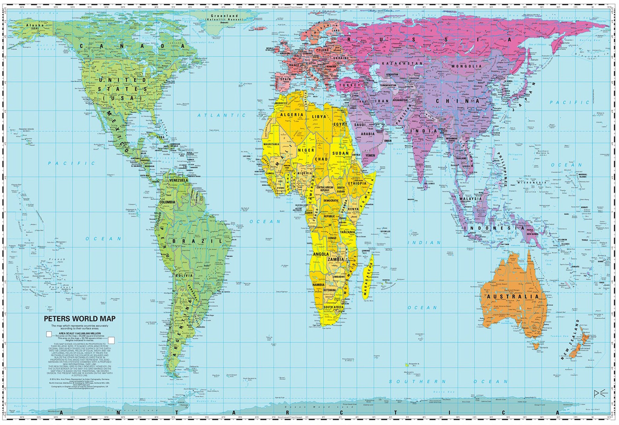
Gall-Peters Equal Area World 1050 x 700mm Wall Map
$69.95
or make 4 interest-free payments of
$17.49 AUD
fortnightly with
![]() More info
More info
Which is bigger, Greenland or China?
With the traditional Mercator map, Greenland and China look the same size, but in reality, China is almost 4 times larger!
In response to such discrepancies, James Gall created the equal-area map in 1855, and during the 1970s, Arno Peters brought the projection to a wider audience. The Gall-Peters World Map dramatically improves the accuracy of how we see the World.
The Peters Projection is an area accurate map (equal-area map). This map shows all areas, countries, continents and oceans, according to their actual size. Accurate comparisons become possible. The Peters Map is an equal axis map. All North-South lines run vertically on this map. Thus geographic points can be seen in their precise directional relationship. The Peters Map shows equal positions. All East-West Lines run parallel. Thus the relationship of any point on the map to its distance from the equator or the sun's angle can readily be determined.
Traditional Mercator projection maps drastically enlarge the size of Northern hemisphere countries and diminish those in the Southern hemisphere - the Gall-Peters challenges this preconception.
The Gall-Peters projection map has been popular in British schools for many years and is actively supported by UNESCO. In March 2017, the U.S. State of Massachusetts started introducing the Gall-Peters World map into public schools in Boston. This initiative gained a considerable amount of attention, and you can see the news.com.au article here:
World map with accurate sizes: Gall-Peters projection throws schools into a spin
The article also includes an excellent video highlighting the differences between the traditional Mercator projection and the Gall-Peters.
This is the perfect map for anyone wanting to understand better the true size of the World - perfect for the classroom or the home.
The map can come either printed on heavyweight 160 gsm paper or laminated. The paper version is perfect for framing under glass, and the laminated version is exceptionally hard-wearing as we use a true encapsulation of two pieces of 80-micron gloss laminate.
Alternatively, we can supply this map on 395 gsm HP Professional Matte Canvas using pigment-based inks - making the map highly durable and fade resistant. The exceptional clarity of printing makes this map a stunning addition to any room, and its high quality means that it will provide years of enjoyment.
The easiest way to hang your canvas map is by having wooden hang rollers attached top and bottom with a hanging cord on the top roller, so all you have to do is put a hook in the wall. The hang rails come lacquered in a natural timber colour.
Note: Please allow 10 working days to deliver hang railed maps as they need to be attached by our framer.
Size: 1050 mm (w) x 700 mm (h)


