- Australia ▾
- Topographic
▾
- Australia AUSTopo 250k (2024)
- Australia 50k Geoscience maps
- Australia 100k Geoscience maps
- Australia 250k Geoscience maps
- Australia 1.1m Geoscience maps
- New Zealand 50k maps
- New Zealand 250k maps
- New South Wales 25k maps
- New South Wales 50k maps
- New South Wales 100k maps
- Queensland 10k maps
- Queensland 25k maps
- Queensland 50k maps
- Queensland 100k maps
- Compasses
- Software
- GPS Systems
- Orienteering
- International ▾
- Wall Maps
▾
- World
- Australia & New Zealand
- Countries, Continents & Regions
- Historical
- Vintage National Geographic
- Australian Capital Territory
- New South Wales
- Northern Territory
- Queensland
- South Australia
- Tasmania
- Victoria
- Western Australia
- Celestial
- Children's
- Mining & Resources
- Wine Maps
- Healthcare
- Postcode Maps
- Electoral Maps
- Nautical ▾
- Flags
▾
- Australian Flag Sets & Banners
- Flag Bunting
- Handwavers
- Australian National Flags
- Aboriginal Flags
- Torres Strait Islander Flags
- International Flags
- Flagpoles & Accessories
- Australian Capital Territory Flags
- New South Wales Flags
- Northern Territory Flags
- Queensland Flags
- South Australia Flags
- Tasmania Flags
- Victoria Flags
- Western Australia Flags
- Gifts ▾
- Globes ▾
Dear valued customer. Please note that our checkout is not supported by old browsers. Please use a recent browser to access all checkout capabilities
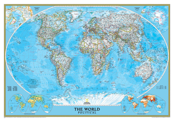
World Political National Geographic 1759 x 1219 mm (Africa Centred) Super Laminated Wall Map with Hang Rails
$499.95
or make 4 interest-free payments of
$124.99 AUD
fortnightly with
![]() More info
More info
By National Geographic | Super Format – 1759 mm (W) x 1219 mm (H) | Laminated | With Timber Hang Rails | Made in Australia
🌍 A Balanced Worldview in a Timeless Design
Elevate your space with this Africa-Centred World Political Map by National Geographic—a superbly detailed and visually elegant representation of our planet that shifts the global perspective. With its cool blue aesthetic, comprehensive political detail, and superior finish, this large-format wall map is ideal for educators, professionals, students, and global thinkers alike.
Carefully designed to combine clarity, accuracy, and visual appeal, this map is a powerful educational resource and a beautiful piece of décor. Its Africa-centred layout offers a balanced view of the world, avoiding traditional Euro-centric bias and presenting the continents in a more proportionate global arrangement.
🌐 A Fresh, Inclusive Perspective
By placing Africa at the centre of the map, this projection promotes a more globally balanced worldview. It allows for a clearer understanding of the interconnections between continents and presents Australia, Asia, Europe, and the Americas in logical proximity.
This layout is especially appreciated in academic, diplomatic, and strategic settings, where geographic neutrality matters.
🔍 Exceptional Cartographic Features
-
Updated Political Detail
All current internationally recognised countries and territories are outlined in bold colour-coded boundaries, while the interiors remain white for maximum legibility of cities, capitals, and place names. -
Topographical Relief
Subtle shaded relief illustrates mountain ranges and physical terrain, giving depth and dimensionality to landmasses. -
Oceanographic Features
Extensive detail of the world's oceans includes currents, depth contours, and bathymetric features—far beyond what standard political maps offer. -
Inset Thematic Maps
Three additional maps in the bottom corners provide essential global data:-
🌍 Population Density
-
🌿 Vegetation Zones
-
🌾 Land Use Patterns
-
These thematic overlays make the map highly functional for education, research, and planning.
-
Winkel Tripel Projection
National Geographic’s standard projection, chosen for its ability to minimize distortion of land area, shape, and direction, particularly near the poles—offering a more accurate and visually balanced world view.
🎨 Elegant Design with Everyday Functionality
With National Geographic’s iconic clean blue colour palette, this map blends effortlessly into both professional and home environments. The fine balance between aesthetic grace and practical function makes it suitable for everything from classroom walls to corporate boardrooms.
🖼️ Laminated + Hang-Ready Finish
| 🧾 Feature | ✅ Description |
|---|---|
| Lamination | Double-sided 80-micron gloss encapsulation over heavy 120 gsm FSC-certified matte-coated paper |
| Writable Surface | Works with whiteboard markers—draw routes, make notes, apply removable map dots |
| Durability | Tear-resistant, stain-proof, moisture-resistant, and UV-protected against fading |
| Hanging Method | Includes lacquered natural timber hang rails top and bottom, with a cotton cord for instant display—just one hook or nail required |
Please allow up to 10 working days for dispatch as timber hang rails are custom-fitted by hand.
📏 Technical Specifications
| Specification | Details |
|---|---|
| Title | World Political Wall Map (Africa-Centred) |
| Publisher | National Geographic Society |
| Projection | Winkel Tripel |
| Scale | 1:22,445,000 |
| Dimensions | 1759 mm (W) × 1219 mm (H) |
| Finish | Laminated with timber hang rails |
| Material | 120 gsm matte-coated FSC paper with gloss lamination |
| Language | English |
| Origin | Printed, laminated, and finished in Australia |
🎯 Who’s This Map For?
| User Type | Why It’s Perfect For Them |
|---|---|
| 🏢 Executives & Planners | An authoritative focal point for boardrooms or planning spaces |
| 🧑🏫 Educators | Combines clarity and thematic overlays for geography and social studies lessons |
| 📚 Researchers | A neutral, accurate view of the world for strategic insight |
| 🧭 Travellers & Families | Mark past travels and dream up future adventures |
| 🎁 Gift Givers | A unique, thoughtful present for history lovers, academics, or anyone with global curiosity |
🚚 Shipping & Delivery
-
✅ Hang-railed maps are shipped in heavy-duty tubes
-
🛠️ Please allow up to 10 business days for hang-railed versions
-
🇦🇺 Proudly made and assembled in Australia
🛒 Add the World to Your Wall
Whether you're exploring international relations, teaching global trends, or simply want a stunning piece of cartographic art, this Africa-Centred World Political Map from National Geographic delivers on all fronts. It's a modern classic—functional, beautiful, and built to last.


