- Australia ▾
- Topographic
▾
- Australia AUSTopo 250k (2024)
- Australia 50k Geoscience maps
- Australia 100k Geoscience maps
- Australia 250k Geoscience maps
- Australia 1.1m Geoscience maps
- New Zealand 50k maps
- New Zealand 250k maps
- New South Wales 25k maps
- New South Wales 50k maps
- New South Wales 100k maps
- Queensland 10k maps
- Queensland 25k maps
- Queensland 50k maps
- Queensland 100k maps
- Compasses
- Software
- GPS Systems
- Orienteering
- International ▾
- Wall Maps
▾
- World
- Australia & New Zealand
- Countries, Continents & Regions
- Historical
- Vintage National Geographic
- Australian Capital Territory
- New South Wales
- Northern Territory
- Queensland
- South Australia
- Tasmania
- Victoria
- Western Australia
- Celestial
- Children's
- Mining & Resources
- Wine Maps
- Healthcare
- Postcode Maps
- Electoral Maps
- Nautical ▾
- Flags
▾
- Australian Flag Sets & Banners
- Flag Bunting
- Handwavers
- Australian National Flags
- Aboriginal Flags
- Torres Strait Islander Flags
- International Flags
- Flagpoles & Accessories
- Australian Capital Territory Flags
- New South Wales Flags
- Northern Territory Flags
- Queensland Flags
- South Australia Flags
- Tasmania Flags
- Victoria Flags
- Western Australia Flags
- Gifts ▾
- Globes ▾
Dear valued customer. Please note that our checkout is not supported by old browsers. Please use a recent browser to access all checkout capabilities
USA Political Wall Map with Relief 1400 x 1020mm
$99.95
or make 4 interest-free payments of
$24.99 AUD
fortnightly with
![]() More info
More info
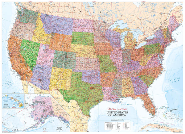
🇺🇸 USA Political Wall Map with Relief – 1400 x 1020 mm
An outstanding large-format political and physical map of the United States, designed for accuracy, beauty, and clarity.
This USA Political Wall Map with Relief from Global Mapping combines detailed cartography with rich topographical shading to create a reference tool that is as visually captivating as it is informative. Whether displayed in a classroom, office, or home, it offers a complete picture of America’s geography, infrastructure, and political divisions.
The relief shading brings the nation’s varied terrain to life, from the Rocky Mountains to the Appalachian range, while the clean political overlay ensures every state, boundary, and transport route is easy to identify.
🌍 Map Coverage & Features
This map includes:
-
All 50 U.S. States, with clearly marked state and county boundaries
-
Major Cities & Towns for quick reference
-
Transportation Networks – railways, highways, and canals
-
Time Zones marked for ease of planning and scheduling
-
Insets of Alaska and Hawaii for complete national coverage
-
Shaded Relief Terrain showing major mountain ranges, plains, and coastlines in stunning detail
🗺️ Cartographic Style
Created with Global Mapping’s signature precision, this map features:
-
A political base layer for boundaries and governance details
-
Physical relief shading for realistic terrain representation
-
Crisp, clear typography optimised for readability from a distance
-
A balance of functionality and decorative appeal, making it equally suited to educational and display purposes
📏 Specifications
| Feature | Detail |
|---|---|
| Publisher | Global Mapping |
| Type | Political & Physical Wall Map |
| Scale | 1:4,000,000 |
| Dimensions | 1400 mm (W) x 1020 mm (H) |
| Insets | Alaska & Hawaii |
| Origin | Made in Australia |
🖌️ Material & Finish Options
Available in five premium finishes to suit any setting:
| Finish | Description |
|---|---|
| Paper (160 gsm) | Heavyweight matte-coated paper – perfect for framing under glass. |
| Laminated | Fully encapsulated with 80-micron gloss laminate – waterproof and tear-resistant. |
| Laminated with Wooden Hang Rails | Laminated map supplied with natural timber hang rails and cord – ready to hang. |
| Canvas (395 gsm) | HP Professional Matte Canvas with archival pigment inks – rich texture, fade-resistant, and highly durable. |
| Canvas with Wooden Hang Rails | Premium canvas mounted with timber hang rails – a timeless, ready-to-hang display. |
🪵 Wooden Hang Rails
For laminated and canvas maps, our wooden hang rails provide an elegant, vintage-style display option. The top rail includes a hanging cord, allowing you to mount your map from a single hook. Rails are finished in natural lacquered timber for a warm, classic look.
Note: Please allow up to 10 working days for delivery of hang-railed maps, as each is custom-mounted by our professional framer.
💡 Why Choose This Map
✔ Dual Detail – Combines political boundaries with physical terrain.
✔ Educational & Decorative – Equally at home in classrooms, offices, or living spaces.
✔ Highly Durable Options – Laminated and canvas finishes protect against wear and fading.
✔ Large Format – 1400 mm width ensures maximum visual impact.
✔ Beautiful Relief Shading – Brings America’s landscape to life.
📦 Perfect For:
-
Teachers and students learning U.S. geography
-
Businesses needing a national reference tool
-
Homeowners seeking a statement wall piece
-
Cartography and history enthusiasts
The USA Political Wall Map with Relief – 1400 x 1020 mm is more than a wall map – it’s a comprehensive, art-quality portrayal of America’s geography and political layout, built to last for years of reference and admiration.


