- Australia ▾
- Topographic
▾
- Australia AUSTopo 250k (2025)
- Australia 50k Geoscience maps
- Australia 100k Geoscience maps
- Australia 250k Geoscience maps
- Australia 1.1m Geoscience maps
- New Zealand 50k maps
- New Zealand 250k maps
- New South Wales 25k maps
- New South Wales 50k maps
- New South Wales 100k maps
- Queensland 10k maps
- Queensland 25k maps
- Queensland 50k maps
- Queensland 100k maps
- Compasses
- Software
- GPS Systems
- Orienteering
- International ▾
- Wall Maps
▾
- World
- Australia & New Zealand
- Countries, Continents & Regions
- Historical
- Vintage National Geographic
- Australian Capital Territory
- New South Wales
- Northern Territory
- Queensland
- South Australia
- Tasmania
- Victoria
- Western Australia
- Celestial
- Children's
- Mining & Resources
- Wine Maps
- Healthcare
- Postcode Maps
- Electoral Maps
- Nautical ▾
- Flags
▾
- Australian Flag Sets & Banners
- Flag Bunting
- Handwavers
- Australian National Flags
- Aboriginal Flags
- Torres Strait Islander Flags
- International Flags
- Flagpoles & Accessories
- Australian Capital Territory Flags
- New South Wales Flags
- Northern Territory Flags
- Queensland Flags
- South Australia Flags
- Tasmania Flags
- Victoria Flags
- Western Australia Flags
- Gifts ▾
- Globes ▾
Dear valued customer. Please note that our checkout is not supported by old browsers. Please use a recent browser to access all checkout capabilities
Vanuatu Wall Map
$59.95
or make 4 interest-free payments of
$14.99 AUD
fortnightly with
![]() More info
More info
Vanuatu Wall Map — Political Overview of the South Pacific
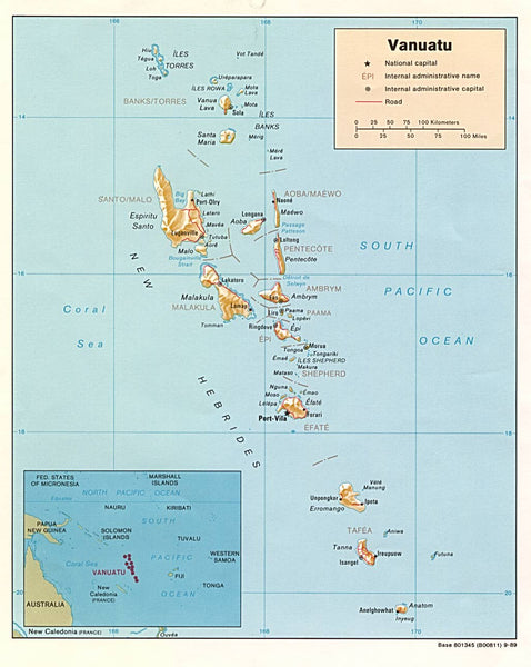
Discover the rich and far-flung geography of Vanuatu, a remarkable island nation stretching across a vast sweep of the South Pacific Ocean, east of Australia and north of New Caledonia. This detailed political wall map presents Vanuatu with clarity and balance, revealing how dozens of islands are scattered across open ocean yet united by shared culture, history, and administration.
Designed as both a reliable reference map and a striking wall display, this edition clearly identifies major islands, internal divisions, and key population centres—making it ideal for education, planning, or simply appreciating the complexity of Pacific island geography.
🌴 An Island Nation in Detail
Vanuatu’s geography is defined by distance, diversity, and volcanic origins. This map brings that structure into sharp focus:
-
Major islands clearly shown, including Espíritu Santo, Malakula, Efate, Tanna, and Aneityum
-
Port Vila prominently marked on Efate as the national capital
-
Smaller towns and administrative centres carefully labelled for practical reference
-
Island groups such as the Banks, Torres, and Shepherd Islands clearly distinguished
-
Clean political styling that emphasises boundaries, names, and spatial relationships
The result is a map that communicates Vanuatu’s geography at a glance—its elongated north–south layout, the spacing between island communities, and the realities of governing a nation spread across open ocean.
🧭 Regional Context & Pacific Perspective
A thoughtfully placed inset map provides essential regional context, situating Vanuatu within its wider Pacific neighbourhood:
-
Solomon Islands to the northwest
-
Fiji to the east
-
New Caledonia to the south
Also shown further north is Tuvalu, one of the world’s smallest and most remote nations. Though tiny in land area, Tuvalu holds an outsized cultural presence in the Pacific, known for its coral atolls, lagoon systems, and strong community traditions centred around the maneapa meeting house.
Together, the main map and inset illustrate how Pacific nations relate across vast ocean distances—connected by culture, history, and sea routes rather than land borders.
🌊 Why This Map Works
-
Clear political focus — ideal for classrooms, offices, and study spaces
-
Excellent Pacific coverage — shows how island nations relate across ocean distances
-
Balanced design — detailed without clutter, informative without overwhelm
-
Educational and decorative — equally suited to learning environments or interior display
This map is particularly valuable for anyone interested in Pacific studies, island nations, development geography, or regional planning.
🖼️ Premium Print & Display Options
Each map is printed in Australia using archival methods to preserve fine detail and long-term clarity.
📄 Heavyweight Paper (160 gsm)
-
Smooth matte finish with excellent line definition
-
Ideal for framing under glass
-
A classic choice for collectors, studies, and heritage interiors
🔒 Laminated (True Encapsulation)
-
Sealed between 2 × 80-micron gloss laminate
-
Tear-resistant, wipe-clean, and highly durable
-
Perfect for offices, libraries, and educational settings
🔒 Laminated + Timber Hang Rails (Ready to Hang)
-
Laminated print fitted with natural timber hang rails (top & bottom)
-
Supplied with hanging cord — no framing required
-
Please allow up to 10 working days for professional attachment
🎨 Archival Canvas (395 gsm HP Professional Matte)
-
Printed on HP 395 gsm Professional Matte Canvas
-
Pigment-based, fade-resistant inks
-
Adds warmth and presence while preserving fine cartographic detail
🎨 Canvas + Timber Hang Rails (Gallery-Ready)
-
Canvas print finished with lacquered natural timber rails
-
Elegant, frame-free presentation
-
Please allow up to 10 working days for completion
📐 Specifications
| Feature | Details |
|---|---|
| Title | Vanuatu Wall Map |
| Region | Vanuatu & Surrounding South Pacific |
| Map Type | Political |
| Key Features | Islands, capital, administrative centres, island groups |
| Inset Map | Regional Pacific context (incl. Tuvalu) |
| Print Size | 840 mm (W) × 685 mm (H) |
| Orientation | Landscape |
| Available Finishes | Paper · Laminated · Laminated + Hang Rails · Canvas · Canvas + Hang Rails |
| Origin | Printed in Australia |
🎯 Ideal For
-
🌏 Geography classrooms & educators
-
🎓 Students of Pacific and island studies
-
🏝️ Travellers and researchers
-
🏢 Government, NGO & planning offices
-
🏠 Homes with a Pacific or coastal theme
Bring the geography of the South Pacific into focus
This Vanuatu Wall Map offers a clear, engaging view of one of the world’s most fascinating island nations—beautifully printed, thoughtfully designed, and ready to display.
Select your preferred finish and bring Vanuatu to your wall today.


