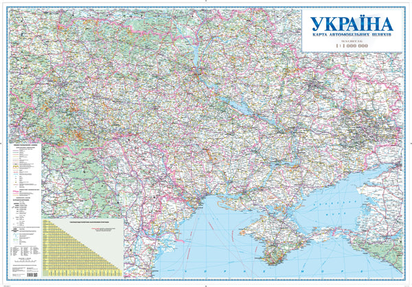
Large-Format | Road Classes & Distances | Premium Finishes
Plan with confidence using a comprehensive, Ukrainian-language wall map of Ukraine’s transportation network. Designed for wall-distance legibility, it clearly presents road classifications, customs checkpoints, fuel stops, and distance markings, using the current national road standard. Recent updates informed by aerial surveys help ensure the information reflects modern routes and revisions—ideal for logistics teams, fleet operations, emergency planning, education, and policy work.
🗺️ Map Features
-
Modern Road Classification
Motorways, national routes, and regional roads depicted with a clear, consistent hierarchy aligned to Ukraine’s current road standards. -
Distance Markings (Kilometrage)
Distances along roads support routing, time estimates, and territory planning at a glance. -
Customs Checkpoints & Crossings
Border and customs points highlighted to assist cross-border operations and compliance planning. -
Fuel & Services Context
Fuel stops and key service points indicated to support route safety and refuelling logistics. -
Aerial-Survey Informed Updates
Recent aerial survey inputs enhance accuracy for roadway alignments and network changes. -
Wall-Optimised Cartography
Balanced colours, crisp typography, and a tidy legend provide clarity without clutter in control rooms, classrooms, and offices. -
Annotation-Friendly (Laminated Option)
Write on / wipe off with non-permanent markers—perfect for shift briefings, lesson plans, and contingency mapping.
Language: Labels and toponymy presented in Ukrainian for authentic local context.
✨ Available Finishes
| Format | Description |
|---|---|
| 📜 Paper (160 gsm) | Heavyweight matte-coated paper—ideal for framing under glass. |
| 🧼 Laminated (Encapsulated) | Fully sealed in 80-micron gloss laminate for a durable, wipe-clean surface. |
| 🪵 Laminated with Wooden Hang Rails | Laminated map mounted with lacquered natural timber rails (top & bottom) and a hanging cord—ready to display. |
| 🖼️ Canvas (395 gsm) | Printed on HP Professional Matte Canvas with archival pigment-based inks—rich texture, fade-resistant, gallery quality. |
| 🪵 Canvas with Wooden Hang Rails | Canvas finished with lacquered timber rails and a hanging cord—timeless, frame-free presentation. |
🔨 Hang-railed maps are made to order—please allow up to 10 working days for professional mounting.
📐 Specifications
| Feature | Detail |
|---|---|
| Title | Ukraine Transportation Network Wall Map (in Ukrainian) |
| Map Type | Transportation / Road Network |
| Language | Ukrainian |
| Scale | 1:1,000,000 |
| Dimensions | 1350 mm (W) × 928 mm (H) |
| Orientation | Landscape |
| Materials | Paper, Laminated, Canvas, With or Without Timber Rails |
| Printing | Pigment-based inks, fade-resistant |
| Data Refresh | Recent aerial-survey informed updates |
💡 Why You’ll Love This Map
-
Operational clarity for routing, dispatch, and cross-border planning.
-
Authoritative symbology aligned to modern Ukrainian road standards.
-
Big-picture view of distances, services, and checkpoints in one place.
-
Display-ready aesthetic that elevates control rooms, classrooms, and offices.
-
Durable finish options for everyday use or gallery-grade presentation.
🚚 Delivery
-
Paper, Laminated, and Canvas (rolled): Usually ships within 1–2 business days.
-
Hang-railed versions: Made to order; allow up to 10 working days.
-
Packaging: Securely protected to arrive in pristine condition.
Put Ukraine’s transport reality on your wall. From customs crossings to kilometrage, this map turns complex routing into clear decisions—precise, current, and ready for action.


