- Australia ▾
- Topographic
▾
- Australia AUSTopo 250k (2025)
- Australia 50k Geoscience maps
- Australia 100k Geoscience maps
- Australia 250k Geoscience maps
- Australia 1:1m Geoscience maps
- New Zealand 50k maps
- New Zealand 250k maps
- New South Wales 25k maps
- New South Wales 50k maps
- New South Wales 100k maps
- Queensland 10k maps
- Queensland 25k maps
- Queensland 50k maps
- Queensland 100k maps
- Western Australia 25k maps
- Western Australia 50k maps
- Western Australia 100k maps
- Compasses
- Software
- GPS Systems
- International ▾
- Wall Maps
▾
- World
- Australia & New Zealand
- Countries, Continents & Regions
- Historical
- Vintage National Geographic
- Australian Capital Territory
- New South Wales
- Northern Territory
- Queensland
- South Australia
- Tasmania
- Victoria
- Western Australia
- Celestial
- Children's
- Mining & Resources
- Wine Maps
- Healthcare
- Postcode Maps
- Electoral Maps
- Nautical ▾
- Flags
▾
- Australian Flag Sets & Banners
- Flag Bunting
- Handwavers
- Australian National Flags
- Aboriginal Flags
- Torres Strait Islander Flags
- International Flags
- Flagpoles & Accessories
- Australian Capital Territory Flags
- New South Wales Flags
- Northern Territory Flags
- Queensland Flags
- South Australia Flags
- Tasmania Flags
- Victoria Flags
- Western Australia Flags
- Gifts ▾
- Globes ▾
Dear valued customer. Please note that our checkout is not supported by old browsers. Please use a recent browser to access all checkout capabilities


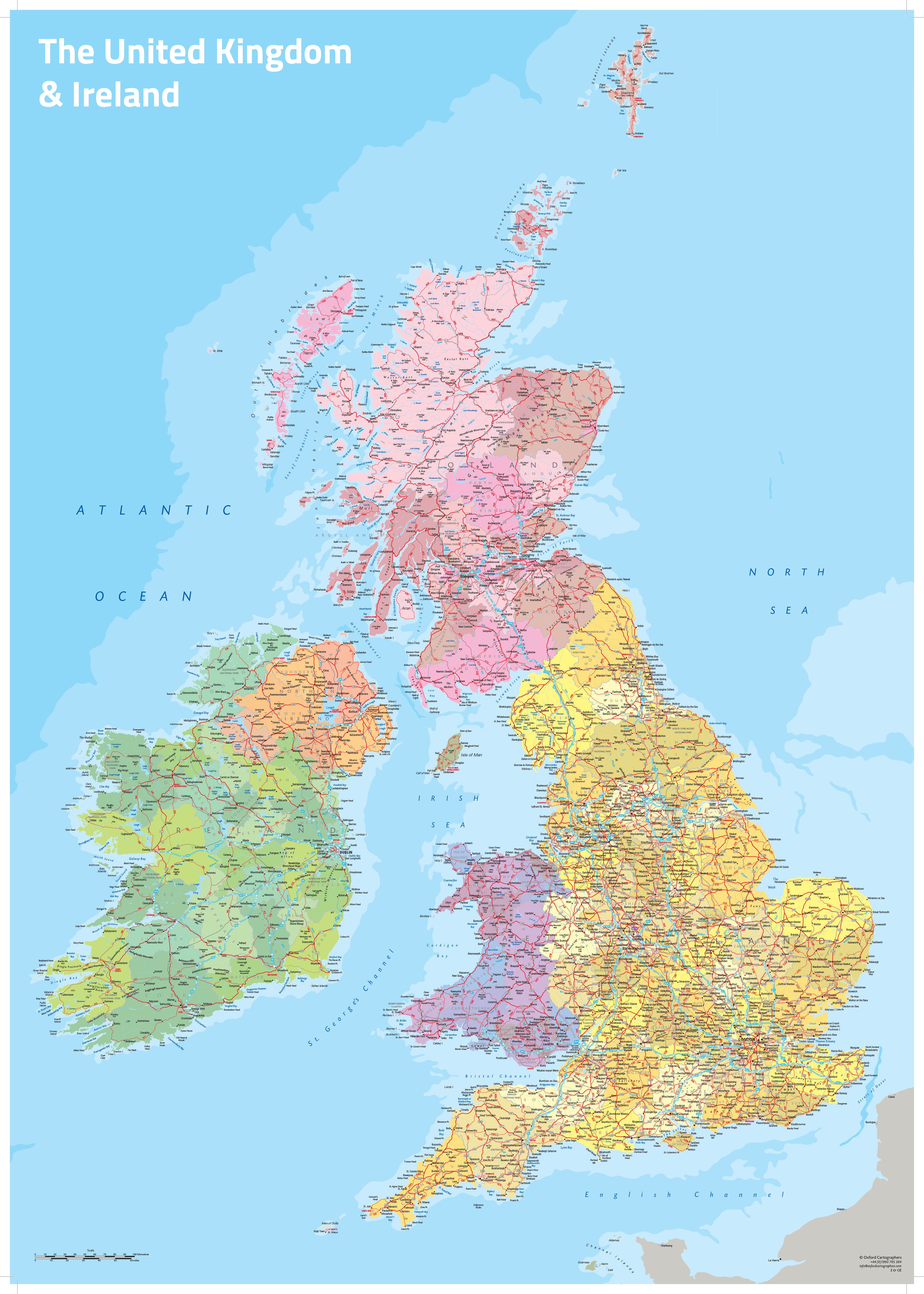
UK & Ireland Political by Oxford Cartographers 594 x 841mm Wall Map
$59.95
or make 4 interest-free payments of
$14.99 AUD
fortnightly with
![]() More info
More info
🇬🇧🇮🇪 UK & Ireland Political Wall Map
Oxford Cartographers • 594 × 841 mm or 1100 × 1540 mm
Celebrate the rich geography and diversity of the British Isles with this beautifully coloured political wall map of the United Kingdom and Ireland — meticulously crafted by Oxford Cartographers, one of the UK’s most respected map publishers.
🗺️ A Vivid Portrait of the British Isles
Whether you're planning a journey, teaching a lesson, or simply want a meaningful piece of cartographic art for your wall, this full-colour map of the UK and Ireland combines clarity, precision, and elegance. Every county is shaded in a distinct colour, making political boundaries instantly recognisable, while towns, cities, and major roads are rendered in exceptional detail.
From the Highlands of Scotland to the southern shores of Cornwall, from Belfast to Dublin, every corner of the British Isles is captured with thoughtful design and cartographic care.
🌟 Why You'll Love It
-
Designed for Visual Impact
Clear, colourful county boundaries combined with subtle relief shading and crisp labelling create a map that is as eye-catching as it is informative. -
Incredible Detail
Includes towns, major roads, rivers, and key transport routes — ideal for planners, educators, students, and curious minds. -
Crafted by Experts
Produced by Oxford Cartographers, renowned for their high-quality educational and reference mapping. -
A Versatile Feature Piece
Perfect for classrooms, home offices, holiday cottages, travel agencies, libraries, or anyone with a love of British and Irish geography.
📐 Available Sizes
| Format | Dimensions (W × H) |
|---|---|
| Standard | 594 mm × 841 mm (A1 size) |
| Large | 1100 mm × 1540 mm |
🖨️ Display & Finish Options
| Option | Description |
|---|---|
| 📄 Paper (Unlaminated) | Printed on 160 gsm matte-coated premium paper. Ideal for framing under glass. |
| 💧 Laminated | Encapsulated in two layers of 80-micron gloss laminate for durability and easy cleaning. |
| 🪵 Laminated + Hang Rails | Laminated map mounted with natural timber hang rails and hanging cord – ready to hang. |
| 🖼️ Canvas (Unframed) | Printed on 395 gsm HP Matte Canvas with archival pigment inks – rich in colour and fade-resistant. |
| 🪵 Canvas + Hang Rails | Canvas version mounted on wooden rails, top and bottom, with cord for a refined display. |
🛠️ Please allow 10 working days for delivery of hang-railed maps, as these are custom-finished by our professional framer.
📊 Product Specifications
| Attribute | Details |
|---|---|
| Title | UK & Ireland Political Wall Map |
| Publisher | Oxford Cartographers |
| Map Type | Political with selected physical features |
| Regions Shown | United Kingdom (England, Scotland, Wales, Northern Ireland) & Ireland |
| Language | English |
| Paper Weight | 160 gsm matte-coated |
| Lamination | 2 × 80-micron gloss laminate |
| Canvas Material | 395 gsm HP Matte Canvas with pigment inks |
| Hang Rails | Timber, lacquered, natural finish, top & bottom |
| Published | Latest available edition |
| Made in | Australia |
🏡 A British Isles Essential
Whether you’re a teacher, a traveller, a proud Brit or Irish local, or someone who just appreciates the artistry of maps — this stunning wall map is a celebration of the land, people, and connections of the UK and Ireland.
🛒 Order your Oxford Cartographers UK & Ireland Political Map today — and bring the British Isles into view, in full colour and magnificent detail.
Frequently Asked Questions
What are the dimensions of the UK & Ireland Political by Oxford Cartographers 594 x 841mm Wall Map?
Mapworld wall maps range from standard 700×1000mm to large-format 1000×1430mm Supermaps. The exact dimensions for this map are shown in the product title. Where multiple sizes are available, select your preferred size when adding to cart.
Is this wall map available laminated?
Many Mapworld wall maps are available in paper, laminated, or framed finishes. Check the product options when adding to cart. Laminated maps are wipe-clean and more durable.
Is this the latest edition?
Mapworld stocks the most current editions available from all publishers. Edition year is shown in the product title where applicable. Mapworld updates its catalogue as new editions are released.
Can I write on or pin this wall map?
Laminated wall maps can be written on with whiteboard markers and wiped clean. Paper maps can be pinned on a corkboard. Choose a laminated option for a writeable surface.
Does Mapworld ship the UK & Ireland Political by Oxford Cartographers 594 x 841mm Wall Map across Australia?
Yes, Mapworld ships Australia-wide. Standard shipping is a flat $7 rate, with free standard shipping on orders over $75. Express options are available at checkout. Most orders placed before 2pm AEST on weekdays are dispatched same day.
Related Items


© 2026 Mapworld. Website designed by Genie Media
X