- Australia ▾
- Topographic
▾
- Australia AUSTopo 250k (2025)
- Australia 50k Geoscience maps
- Australia 100k Geoscience maps
- Australia 250k Geoscience maps
- Australia 1:1m Geoscience maps
- New Zealand 50k maps
- New Zealand 250k maps
- New South Wales 25k maps
- New South Wales 50k maps
- New South Wales 100k maps
- Queensland 10k maps
- Queensland 25k maps
- Queensland 50k maps
- Queensland 100k maps
- Western Australia 25k maps
- Western Australia 50k maps
- Western Australia 100k maps
- Compasses
- Software
- GPS Systems
- International ▾
- Wall Maps
▾
- World
- Australia & New Zealand
- Countries, Continents & Regions
- Historical
- Vintage National Geographic
- Australian Capital Territory
- New South Wales
- Northern Territory
- Queensland
- South Australia
- Tasmania
- Victoria
- Western Australia
- Celestial
- Children's
- Mining & Resources
- Wine Maps
- Healthcare
- Postcode Maps
- Electoral Maps
- Nautical ▾
- Flags
▾
- Australian Flag Sets & Banners
- Flag Bunting
- Handwavers
- Australian National Flags
- Aboriginal Flags
- Torres Strait Islander Flags
- International Flags
- Flagpoles & Accessories
- Australian Capital Territory Flags
- New South Wales Flags
- Northern Territory Flags
- Queensland Flags
- South Australia Flags
- Tasmania Flags
- Victoria Flags
- Western Australia Flags
- Gifts ▾
- Globes ▾
Dear valued customer. Please note that our checkout is not supported by old browsers. Please use a recent browser to access all checkout capabilities


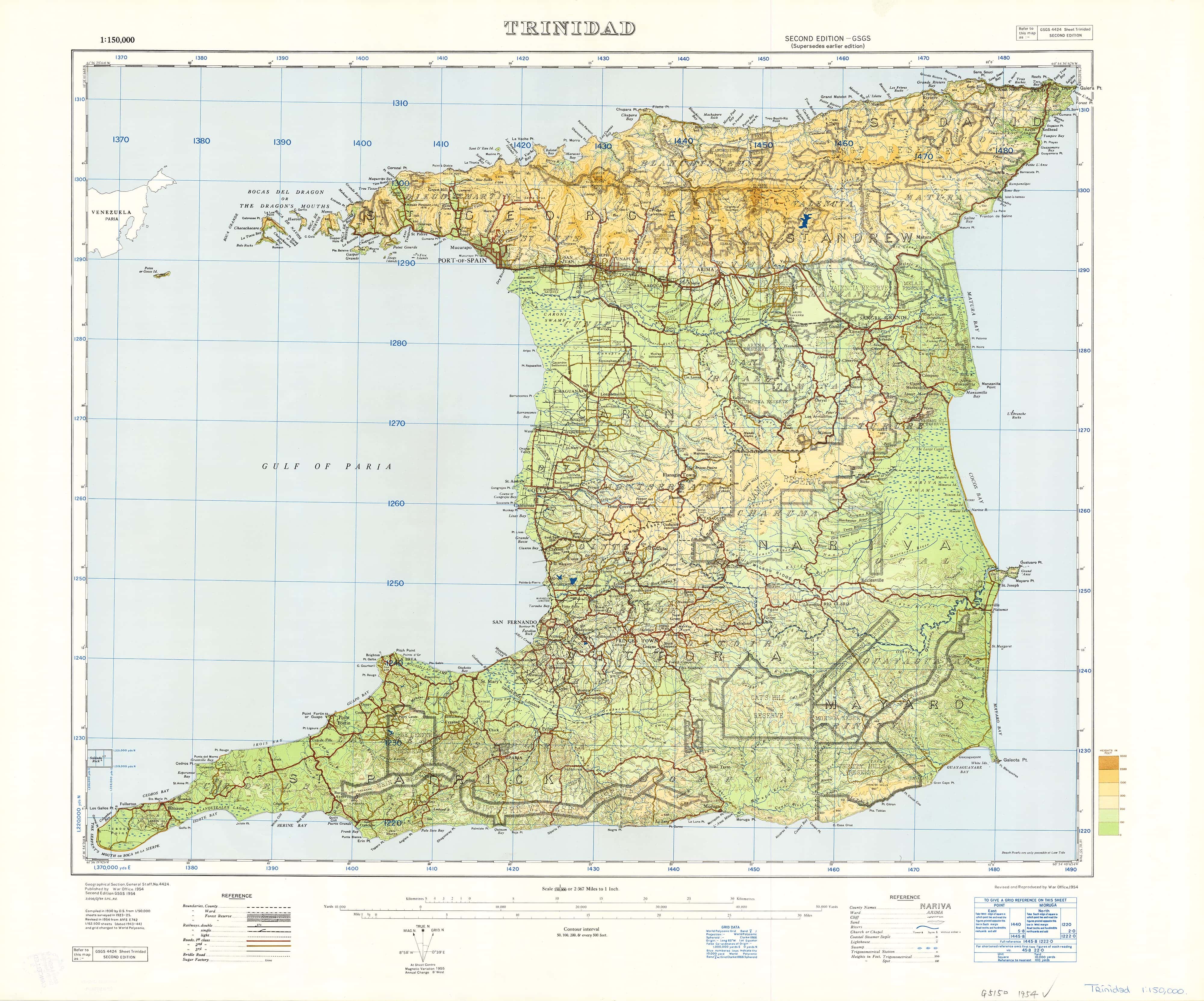
Trinidad, West Indies Ordinance Survey 1923 - Land of Calypso
$59.95
or make 4 interest-free payments of
$14.99 AUD
fortnightly with
![]() More info
More info
Historical War Office Map | Exceptional Detail | Beautiful Heritage Piece
Size: 780 mm (W) x 630 mm (H)
Available in Paper, Laminated, Canvas, and Canvas with Timber Hang Rails
Step into the past with one of the most detailed and captivating maps ever produced of Trinidad. Commissioned by the British War Office and compiled from data collected between 1923 and 1925, this map was published in 1954, long before Piarco International Airport existed or modern development transformed the island.
Whether you're a proud Trini wanting to honour your roots, a history buff exploring colonial cartography, or someone discovering the real Trinidad beyond the postcards—this map is a masterpiece of place names, coastal markers, and cultural memory.
🧭 Why This Map Is So Special
-
🔍 Incredible Place Name Density – Towns, rivers, bays, estates, and rural villages all named with unrivalled detail
-
🌊 Detailed Coastline Mapping – Dozens of minor coastal features labeled and preserved
-
🕰️ Pre-Modern Trinidad – Offers a rare view of the island before airports, motorways, and modern expansion
-
🎨 Aesthetically Beautiful – Vintage typography, fine linework, and natural terrain rendering
❤️ Who Is It For?
-
🇹🇹 Every Trini, near or far – reconnect with the land, the language, and the legacy
-
👨👩👧👦 Families & educators – teach the next generation about their heritage and geography
-
📚 Researchers & historians – examine colonial and pre-modern land use and settlement patterns
-
🏡 Interior decorators – add timeless vintage charm to any study, hallway, or lounge
-
🗺️ Collectors & map lovers – own a rare and beautiful piece of Caribbean cartographic history
🗨️ "To remember home. To teach the kids. To discover the Trinidad you thought you already knew."
📌 Format Options
| Format | Description |
|---|---|
| 📄 Paper (160gsm) | Archival-quality matte paper – ideal for framing under glass |
| 🛡️ Laminated | Encapsulated in 80-micron gloss laminate – wipeable, tear- and stain-resistant |
| 🖼️ Canvas (395gsm) | Printed on premium HP Professional Matte Canvas – fade-resistant and richly textured |
| 🪵 Canvas + Hang Rails | Canvas version with natural timber hang rails and hanging cord – ready to hang on the wall |
🪵 Canvas & Laminated Versions with Timber Rails
For a gallery-style display, choose a canvas or laminated map with wooden hang rails:
-
🪵 Top and bottom hang rails, lacquered in natural timber
-
🧵 Pre-attached cord on the top rail for easy, elegant hanging
-
✅ No additional framing required
-
🖼️ Perfect for home offices, libraries, schools, or cultural spaces
📦 Please allow up to 10 working days for delivery of hang-railed maps, as each is professionally hand-finished.
📐 Product Specifications
| Attribute | Detail |
|---|---|
| Title | Trinidad, West Indies Ordnance Survey Map (1923–1954) |
| Publisher | War Office / Ordnance Survey |
| Map Type | Historical reproduction |
| Size | 780 mm (W) x 630 mm (H) |
| Formats Available | Paper, Laminated, Canvas, Canvas + Hang Rails |
| Print Quality | Full-colour, high-resolution facsimile reproduction |
| Made In | Australia |
🛒 Add to Cart – A Tribute to the Land of Calypso
This is more than just a map—it’s a window into Trinidad’s past, beautifully restored and available in archival formats to cherish for years to come. Whether you hang it proudly in your home, gift it to family overseas, or use it to teach and inspire, the 1923 Trinidad Ordnance Survey Map is a timeless piece of Caribbean heritage.
Frequently Asked Questions
What are the dimensions of the Trinidad, West Indies Ordinance Survey 1923 - Land of Calypso?
Mapworld wall maps range from standard 700×1000mm to large-format 1000×1430mm Supermaps. The exact dimensions for this map are shown in the product title. Where multiple sizes are available, select your preferred size when adding to cart.
Is this wall map available laminated?
Many Mapworld wall maps are available in paper, laminated, or framed finishes. Check the product options when adding to cart. Laminated maps are wipe-clean and more durable.
Is this the latest edition?
Mapworld stocks the most current editions available from all publishers. Edition year is shown in the product title where applicable. Mapworld updates its catalogue as new editions are released.
Can I write on or pin this wall map?
Laminated wall maps can be written on with whiteboard markers and wiped clean. Paper maps can be pinned on a corkboard. Choose a laminated option for a writeable surface.
Does Mapworld ship the Trinidad, West Indies Ordinance Survey 1923 - Land of Calypso across Australia?
Yes, Mapworld ships Australia-wide. Standard shipping is a flat $7 rate, with free standard shipping on orders over $75. Express options are available at checkout. Most orders placed before 2pm AEST on weekdays are dispatched same day.
Related Items


© 2026 Mapworld. Website designed by Genie Media
X