Physical & Political Detail | Suez to Bab el-Mandeb | Relief & Coastal Contours | Premium Finishes
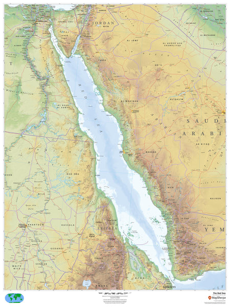
Command a panoramic view of the Red Sea—from the Suez Canal approaches and Gulf of Aqaba in the north to the Bab el-Mandeb strait in the south. This large-format wall map layers clear political boundaries over beautiful physical cartography, using relief shading and elevation colour-bands to reveal coastal ranges, plateaus, and lowlands across Egypt, Sudan, Eritrea, Djibouti, Saudi Arabia, and Yemen. Towns, borders, and shorelines are rendered with wall-optimised clarity—ideal for education, travel planning, maritime context, and elegant display.
🗺️ What’s Shown — In Depth
-
Physical + Political Layers
International borders, key cities/towns, and primary routes over a finely shaded terrain base for instant geographic orientation. -
Relief & Elevation Tints
Hillshading and hypsometric colours make mountain fronts (e.g., Hejaz and Asir ranges) and coastal plains (Tihama) pop at a glance. -
Coastal & Island Detail
Shorelines, gulfs, peninsulas, and islands—including the Gulf of Suez, Gulf of Aqaba, and notable archipelagos—are clearly depicted for coastal context. -
Hydrology & Inlets
Estuaries, wadis, and lagoons are shown to illustrate how the desert meets the sea along this unique rift-sea corridor. -
Wall-Optimised Cartography
Disciplined label hierarchy and clean symbology deliver clarity without clutter from typical wall-viewing distances.
Ports, islands, routes, and additional features appear as depicted on the map.
🌍 Regional Highlights (Great for Teaching & Briefings)
-
Northern Gateways – Suez and the Gulf of Aqaba provide context for the canal approaches and Levantine linkages.
-
Central Reaches – The Saudi and Sudanese/Eritrean littorals show contrasting relief and settlement patterns along the rift basin.
-
Southern Gateway – The narrow Bab el-Mandeb situates the Red Sea within wider Indian Ocean and Gulf of Aden trade geographies.
-
Islands & Reefs – Coastal islands and reef-dotted shelves (where shown) highlight navigation and conservation talking points.
👥 Perfect For
-
Educators & Students – Regional geography, geopolitics, trade corridors, and environmental studies.
-
Maritime & Logistics Teams – Boardroom briefings, routing context, and stakeholder presentations.
-
Travel, Conservation & Heritage – Orientation for itineraries, coastal ecology, and cultural-historic discussions.
-
Home & Office Décor – A sophisticated focal piece that’s as informative as it is beautiful.
✨ Available Finishes
| Format | Description |
|---|---|
| 📜 Paper (160 gsm) | Heavyweight matte-coated paper—perfect for framing under glass. |
| 🧼 Laminated (Encapsulated) | Fully sealed in 80-micron gloss laminate—durable, wipe-clean, and annotation-friendly. |
| 🪵 Laminated with Wooden Hang Rails | Laminated map mounted with lacquered natural timber rails (top & bottom) and a hanging cord—ready to display. |
| 🖼️ Canvas (395 gsm) | HP Professional Matte Canvas printed with archival pigment-based inks—rich texture, fade-resistant, gallery-grade. |
| 🪵 Canvas with Wooden Hang Rails | Canvas finished with lacquered timber rails and a hanging cord—timeless, frame-free presentation. |
🔨 Hang-railed maps are made to order—please allow up to 10 working days for professional mounting.
📐 Specifications
| Feature | Detail |
|---|---|
| Title | The Red Sea Wall Map |
| Map Type | Physical / Political |
| Scale | 1:2,000,000 (≈ 1 cm represents 20 km) |
| Dimensions | 914 mm (W) × 1219 mm (H) |
| Orientation | Portrait |
| Materials | Paper, Laminated, Canvas, With or Without Timber Rails |
| Printing | Archival pigment-based inks, fade-resistant |
💡 Why You’ll Love It
-
Strategic waterway at a glance—from canal approaches to the Indian Ocean gateway.
-
Elegant relief & elevation bring coastlines and hinterlands to life for instant comprehension.
-
Clear political framing for lessons, planning sessions, and presentations.
-
Five premium finishes suit classrooms, offices, studios, and living spaces.
-
Durability options (laminated/canvas) for high-use environments.
🚚 Delivery
-
Paper, Laminated & Canvas (rolled): Usually ships within 1–2 business days.
-
Hang-railed versions: Made to order; allow up to 10 working days.
-
Packaging: Securely protected to arrive in pristine condition.
Bring the Red Sea’s geography into daily focus. Choose your finish, hang with ease, and enjoy a map that’s both striking and deeply useful.


