- Australia ▾
- Topographic
▾
- Australia AUSTopo 250k (2025)
- Australia 50k Geoscience maps
- Australia 100k Geoscience maps
- Australia 250k Geoscience maps
- Australia 1:1m Geoscience maps
- New Zealand 50k maps
- New Zealand 250k maps
- New South Wales 25k maps
- New South Wales 50k maps
- New South Wales 100k maps
- Queensland 10k maps
- Queensland 25k maps
- Queensland 50k maps
- Queensland 100k maps
- Western Australia 25k maps
- Western Australia 50k maps
- Western Australia 100k maps
- Compasses
- Software
- GPS Systems
- International ▾
- Wall Maps
▾
- World
- Australia & New Zealand
- Countries, Continents & Regions
- Historical
- Vintage National Geographic
- Australian Capital Territory
- New South Wales
- Northern Territory
- Queensland
- South Australia
- Tasmania
- Victoria
- Western Australia
- Celestial
- Children's
- Mining & Resources
- Wine Maps
- Healthcare
- Postcode Maps
- Electoral Maps
- Nautical ▾
- Flags
▾
- Australian Flag Sets & Banners
- Flag Bunting
- Handwavers
- Australian National Flags
- Aboriginal Flags
- Torres Strait Islander Flags
- International Flags
- Flagpoles & Accessories
- Australian Capital Territory Flags
- New South Wales Flags
- Northern Territory Flags
- Queensland Flags
- South Australia Flags
- Tasmania Flags
- Victoria Flags
- Western Australia Flags
- Gifts ▾
- Globes ▾
Dear valued customer. Please note that our checkout is not supported by old browsers. Please use a recent browser to access all checkout capabilities


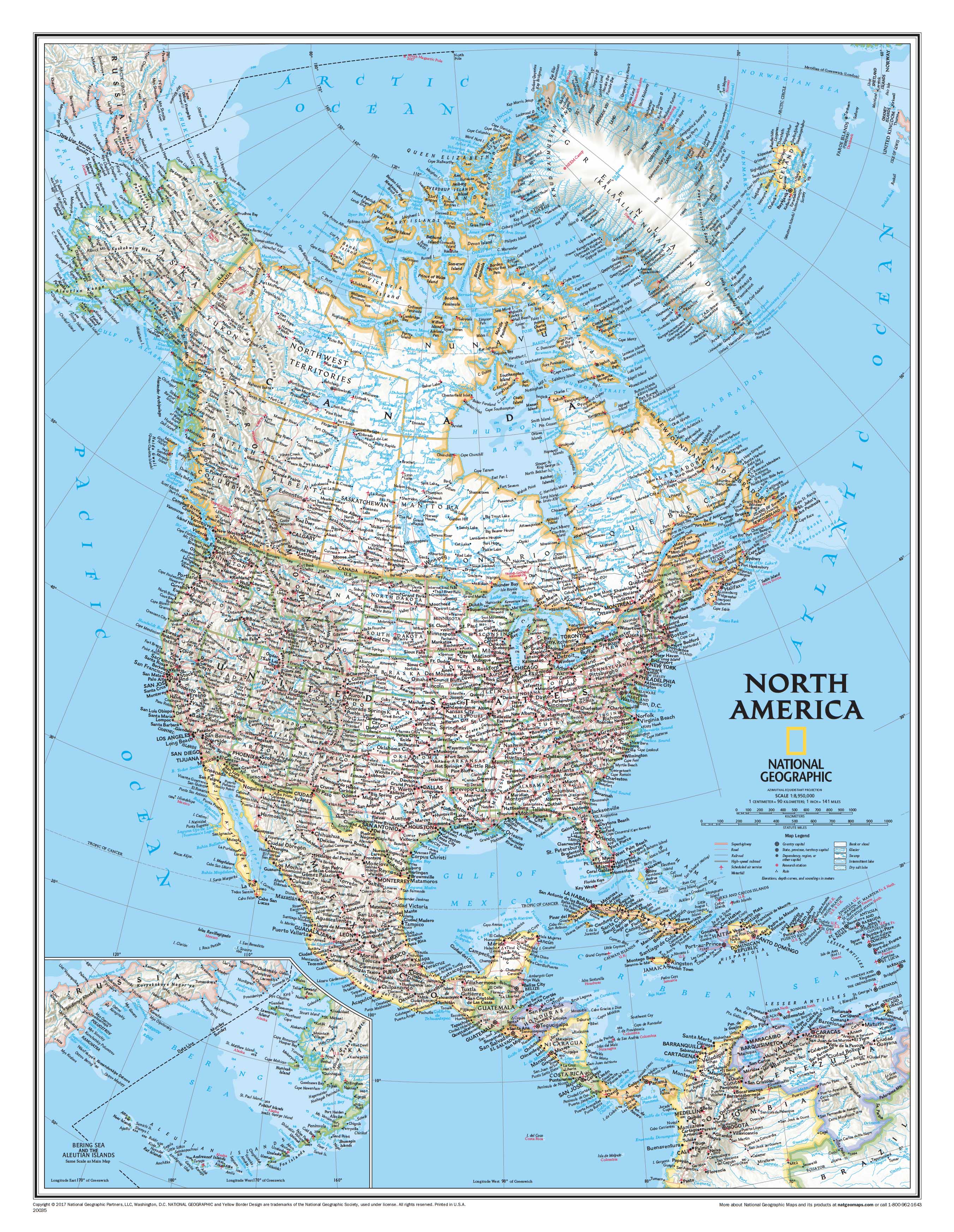
North America National Geographic 908 x 1117mm Wall Map
$79.95
or make 4 interest-free payments of
$19.99 AUD
fortnightly with
![]() More info
More info
North America – National Geographic Wall Map
Size: 908 mm (W) × 1117 mm (H) | Scale: 1:8,950,000 | Made in Australia
From the icy expanse of the Arctic Ocean to the tropical lowlands of Panama, National Geographic’s Classic-style wall map of North America offers an authoritative and beautifully designed overview of the continent. Combining political clarity with stunning shaded relief, it captures both natural landscapes and human boundaries in the timeless cartographic tradition that has defined National Geographic for over 75 years.
This map provides a comprehensive view not only of Canada, the United States, Mexico, and Central America, but also includes Iceland, Greenland, the Caribbean islands, Venezuela, and much of Colombia. An inset details the remote Aleutian Islands off Alaska’s coast, ensuring complete continental coverage.
🌟 Key Map Features
-
Comprehensive Continental Coverage – From the Arctic Circle to Panama, with extended coverage of Greenland, Iceland, and the Caribbean.
-
Shaded Relief Terrain – Mountain ranges, plains, and coastlines are brought to life in subtle 3D-like depth.
-
Ocean Bathymetry – Depth contours of surrounding seas provide insight into underwater landscapes.
-
Political Boundaries – Clearly defined borders between countries, states, and provinces.
-
Detailed Labelling – Thousands of place names, including capitals, cities, airports, major highways, and ferry routes.
-
Classic National Geographic Design – A bright, easy-to-read palette with blue oceans and crisp typography.
📐 Technical Specifications
| Feature | Detail |
|---|---|
| Title | North America – National Geographic Wall Map |
| Size | 908 mm (W) × 1117 mm (H) |
| Scale | 1:8,950,000 |
| Publisher | National Geographic |
| Style | Classic – Political & Physical |
| Origin | Made in Australia |
✨ Available Finishes
Choose the presentation style that best suits your needs:
📜 Paper (160 gsm Premium Stock)
-
Heavyweight matte-coated paper.
-
Perfect for framing under glass.
✨ Laminated (Encapsulated, 80 Micron Gloss)
-
Fully encapsulated between two layers of protective gloss film.
-
Tear-resistant, durable, and easy to clean — ideal for schools or offices.
🪵 Laminated with Wooden Hang Rails
-
Encapsulated map mounted with lacquered timber rails and a hanging cord.
-
A ready-to-display option, perfect for libraries, classrooms, and homes.
🖼️ Canvas (395 gsm Professional Matte)
-
Printed on archival-grade HP Matte Canvas using pigment-based inks.
-
Rich, fade-resistant surface with superb print clarity.
🪵 Canvas with Wooden Hang Rails
-
Premium canvas map fitted with natural timber hang rails and cord.
-
A heritage-style statement piece ready to hang.
🔨 Please allow up to 10 working days for hang-railed maps, as each is custom-mounted by our professional framer.
💡 Why Choose This Map
✔️ Authoritative Detail – Trusted National Geographic cartography.
✔️ Educational & Decorative – Equally suited to classrooms, offices, and home studies.
✔️ Durable Materials – Options built for both everyday use and long-term display.
✔️ Flexible Display – From rollable paper maps to ready-to-hang canvas editions.
✔️ A Conversation Piece – Brings the geography of North America to life.
📦 Packaging & Delivery
-
Paper & Laminated Maps – Delivered rolled in secure mailing tubes.
-
Canvas & Hang-Railed Versions – Professionally packaged for safe transport.
-
Australia-wide & International Shipping available.
🌏 A Continental Masterpiece
With its blend of beauty, accuracy, and heritage styling, the North America National Geographic Wall Map is more than a reference — it’s a timeless work of cartographic art. Perfect for anyone with ties to the continent, from students and educators to travellers and collectors, it celebrates North America in all its geographic diversity.
👉 Select your preferred finish above and make this iconic map the centrepiece of your wall today.
Frequently Asked Questions
What are the dimensions of the North America National Geographic 908 x 1117mm Wall Map?
Mapworld wall maps range from standard 700×1000mm to large-format 1000×1430mm Supermaps. The exact dimensions for this map are shown in the product title. Where multiple sizes are available, select your preferred size when adding to cart.
Is this wall map available laminated?
Many Mapworld wall maps are available in paper, laminated, or framed finishes. Check the product options when adding to cart. Laminated maps are wipe-clean and more durable.
Is this the latest edition?
Mapworld stocks the most current editions available from all publishers. Edition year is shown in the product title where applicable. Mapworld updates its catalogue as new editions are released.
Can I write on or pin this wall map?
Laminated wall maps can be written on with whiteboard markers and wiped clean. Paper maps can be pinned on a corkboard. Choose a laminated option for a writeable surface.
Does Mapworld ship the North America National Geographic 908 x 1117mm Wall Map across Australia?
Yes, Mapworld ships Australia-wide. Standard shipping is a flat $7 rate, with free standard shipping on orders over $75. Express options are available at checkout. Most orders placed before 2pm AEST on weekdays are dispatched same day.
Related Items


© 2026 Mapworld. Website designed by Genie Media
X