- Australia ▾
- Topographic
▾
- Australia AUSTopo 250k (2024)
- Australia 50k Geoscience maps
- Australia 100k Geoscience maps
- Australia 250k Geoscience maps
- Australia 1.1m Geoscience maps
- New Zealand 50k maps
- New Zealand 250k maps
- New South Wales 25k maps
- New South Wales 50k maps
- New South Wales 100k maps
- Queensland 10k maps
- Queensland 25k maps
- Queensland 50k maps
- Queensland 100k maps
- Compasses
- Software
- GPS Systems
- Orienteering
- International ▾
- Wall Maps
▾
- World
- Australia & New Zealand
- Countries, Continents & Regions
- Historical
- Vintage National Geographic
- Australian Capital Territory
- New South Wales
- Northern Territory
- Queensland
- South Australia
- Tasmania
- Victoria
- Western Australia
- Celestial
- Children's
- Mining & Resources
- Wine Maps
- Healthcare
- Postcode Maps
- Electoral Maps
- Nautical ▾
- Flags
▾
- Australian Flag Sets & Banners
- Flag Bunting
- Handwavers
- Australian National Flags
- Aboriginal Flags
- Torres Strait Islander Flags
- International Flags
- Flagpoles & Accessories
- Australian Capital Territory Flags
- New South Wales Flags
- Northern Territory Flags
- Queensland Flags
- South Australia Flags
- Tasmania Flags
- Victoria Flags
- Western Australia Flags
- Gifts ▾
- Globes ▾
Dear valued customer. Please note that our checkout is not supported by old browsers. Please use a recent browser to access all checkout capabilities
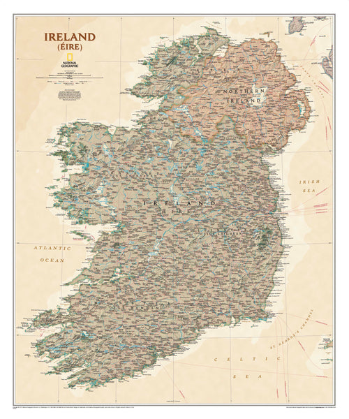
Ireland Executive Antique Style National Geographic 914 x 762mm Wall Map
$69.95
or make 4 interest-free payments of
$17.49 AUD
fortnightly with
![]() More info
More info
🇮🇪 Ireland — Executive Antique Style Wall Map
By National Geographic | Size: 914 mm (H) x 762 mm (W)
Published: 2019 | Made in Australia
🍀 A Timeless Tribute to the Emerald Isle
Discover the magic, the heritage, and the sweeping geography of Ireland with this elegant Executive Style Wall Map from National Geographic. Rendered in soft earth tones with antique styling, this map captures not only the physical contours of the island but also the spirit of a proud and enduring culture.
Whether you're honouring your Irish ancestry, decorating a space with heritage in mind, or seeking a refined map for study or business reference, this is a cartographic masterpiece that inspires as much as it informs.
📚 Bilingual Elegance and Cultural Accuracy
Crafted in alignment with the Irish Constitution, this map is one of the most culturally accurate depictions of modern Ireland ever produced. With nearly 1,000 place names, it presents:
-
🟢 Irish-language (Gaelic) names in the Gaeltacht regions, where Irish holds primary official status
-
🔵 English place names elsewhere, with Irish variants included in parentheses
-
📍 An authentic and respectful portrayal of both modern and historical Ireland, suitable for educational, genealogical, and decorative use
Regions like Cork, Donegal, Galway, Kerry, Mayo, Meath, and Waterford are all highlighted with linguistic detail, making this map especially powerful for those researching their heritage or celebrating Irish culture.
🌍 What the Map Shows
Designed for both beauty and utility, this map covers both the Republic of Ireland and Northern Ireland in meticulous detail. Features include:
-
🏙 Over 1,000 named locations, including cities, towns, and villages
-
🛣 Major road networks, railways, and infrastructure
-
🗺 Clearly defined county boundaries and political regions
-
🏰 Selected historical and cultural sites of significance
-
🧭 Antique-style compass rose and decorative cartographic elements
-
🌄 Gentle shaded relief that brings Ireland’s topography to life
-
📌 Presented in National Geographic’s Executive Style, with muted tones, sophisticated fonts, and an antique finish perfect for refined interiors
🎯 Who Is This Map For?
This premium wall map is ideal for:
-
🧬 Genealogists tracing family history across Irish counties
-
🏛️ Educators teaching language, geography, or history
-
🗂️ Business professionals requiring a reliable and beautiful reference
-
🎁 Gift-givers looking for something meaningful and refined
-
🍀 Lovers of Ireland wishing to bring a piece of the Emerald Isle home
Whether hung in a study, office, classroom, pub, or family home, this map adds an elegant layer of depth to any space.
📦 Premium Format Options
To suit different display styles and durability needs, this map is available in the following formats:
| Format | Description |
|---|---|
| Paper (160 gsm) | Perfect for framing under glass. Smooth matte finish, lightweight, and collector-quality. |
| Laminated | Dual-sided 80-micron gloss encapsulation. Waterproof, wipeable, and exceptionally durable. |
| Canvas (395 gsm) | Printed on museum-grade HP Professional Matte Canvas using pigment-based inks. Textured, vibrant, and fade-resistant—ideal for heritage displays. |
🪵 Optional Wooden Hang Rails
Add a refined and traditional presentation with our optional natural timber hang rails:
-
🪚 Lacquered wood rails top and bottom
-
🧵 Hanging cord attached to the top rail for easy wall mounting
-
✨ Available for both laminated and canvas versions
-
🖼️ A perfect match for vintage decor, libraries, and heritage-themed rooms
Please note: Allow 10 working days for delivery on hang-railed maps, as each piece is custom-assembled by our framer.
🧵 Specifications at a Glance
| Feature | Detail |
|---|---|
| Map Title | Ireland – Executive Antique Style Wall Map |
| Publisher | National Geographic (11th Edition World Atlas Series) |
| Style | Executive (Antique finish with muted tones) |
| Place Names | Bilingual (English and Irish / Gaelic) |
| Coverage | Republic of Ireland and Northern Ireland |
| Size | 914 mm (high) x 762 mm (wide) |
| Scale | Approx. 1:1,100,000 |
| Published | 2019 |
| Made in | Australia |
| Formats Available | Paper, Laminated, Canvas |
| Optional Upgrades | Hang Rails for Laminated & Canvas |
| Delivery Note | Hang-railed options require 10 working days |
🍀 Why Choose This Map?
The Ireland Executive Wall Map isn’t just a tool for navigation—it’s a celebration of national identity, a window into centuries of culture, and a statement piece that elevates any space.
From the quiet coastlines of Donegal to the bustling streets of Dublin, from Gaelic-speaking enclaves to windswept rural towns, every inch of this map tells a story. Let it be part of yours.
🛒 Bring Ireland Home
Embrace the legacy, the language, and the landscape of Ireland. Choose your format and order today—and transform your wall into a tribute to the Emerald Isle.
Would you like to pair it with matching maps of Scotland, Wales, or the full British Isles? We're happy to help complete your collection.


