- Australia ▾
- Topographic
▾
- Australia AUSTopo 250k (2025)
- Australia 50k Geoscience maps
- Australia 100k Geoscience maps
- Australia 250k Geoscience maps
- Australia 1:1m Geoscience maps
- New Zealand 50k maps
- New Zealand 250k maps
- New South Wales 25k maps
- New South Wales 50k maps
- New South Wales 100k maps
- Queensland 10k maps
- Queensland 25k maps
- Queensland 50k maps
- Queensland 100k maps
- Western Australia 25k maps
- Western Australia 50k maps
- Western Australia 100k maps
- Compasses
- Software
- GPS Systems
- International ▾
- Wall Maps
▾
- World
- Australia & New Zealand
- Countries, Continents & Regions
- Historical
- Vintage National Geographic
- Australian Capital Territory
- New South Wales
- Northern Territory
- Queensland
- South Australia
- Tasmania
- Victoria
- Western Australia
- Celestial
- Children's
- Mining & Resources
- Wine Maps
- Healthcare
- Postcode Maps
- Electoral Maps
- Nautical ▾
- Flags
▾
- Australian Flag Sets & Banners
- Flag Bunting
- Handwavers
- Australian National Flags
- Aboriginal Flags
- Torres Strait Islander Flags
- International Flags
- Flagpoles & Accessories
- Australian Capital Territory Flags
- New South Wales Flags
- Northern Territory Flags
- Queensland Flags
- South Australia Flags
- Tasmania Flags
- Victoria Flags
- Western Australia Flags
- Gifts ▾
- Globes ▾
Dear valued customer. Please note that our checkout is not supported by old browsers. Please use a recent browser to access all checkout capabilities


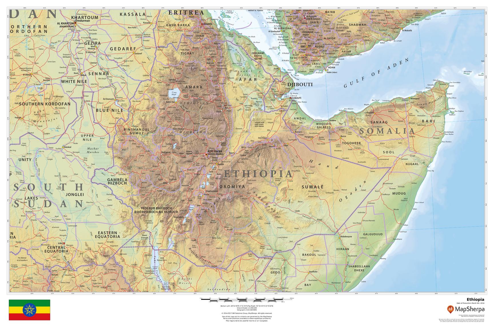
Ethiopia Wall Map 914 x 610mm
$69.95
or make 4 interest-free payments of
$17.49 AUD
fortnightly with
![]() More info
More info
Physical & Political Detail | Shaded Relief | Premium Finishes
Discover Ethiopia in vivid detail with this beautifully designed wall map, showcasing both physical terrain and political boundaries. Elegant relief shading and color-by-elevation make mountains, plateaus, and valleys leap off the page, while key cities, roads, rivers, lakes, and borders are clearly labeled for effortless reference.
🗺️ Features & Highlights
-
Physical + Political Coverage: See Ethiopia’s regions, major settlements, transport routes, and waterways at a glance.
-
Relief Shading & Elevation Colors: Intuitive color gradients reveal the dramatic highlands and Rift Valley.
-
Clarity You Can Trust: Clean typography and balanced labeling for study, planning, or décor.
-
Contextual Geography: Includes surrounding areas for regional orientation and travel planning.
✨ Available Finishes
| Format | Description |
|---|---|
| 📜 Paper (160 gsm) | Heavyweight matte-coated paper—perfect for framing under glass. |
| 🧼 Laminated (Encapsulated) | Fully sealed between two sheets of 80-micron gloss laminate—durable, wipe-clean, classroom-ready. |
| 🪵 Laminated with Wooden Hang Rails | Laminated map mounted with lacquered natural timber rails (top & bottom) plus a sturdy hanging cord—ready to display. |
| 🖼️ Canvas (395 gsm) | Printed on HP Professional Matte Canvas with archival pigment inks—rich texture, fade-resistant, gallery quality. |
| 🪵 Canvas with Wooden Hang Rails | Canvas mounted with timber rails and hanging cord for a timeless, ready-to-hang presentation—no frame required. |
🔨 Note: Hang-railed maps are custom mounted—please allow up to 10 working days.
📐 Specifications
| Feature | Detail |
|---|---|
| Title | Ethiopia Wall Map |
| Map Type | Physical / Political |
| Scale | 1:3,000,000 |
| Dimensions | 914 mm (W) × 610 mm (H) |
| Materials | Paper, Laminated, Canvas, with or without Timber Rails |
| Printing | Pigment-based, fade-resistant inks |
🎁 Perfect For
-
Homes & Offices: A sophisticated statement piece with educational value.
-
Classrooms & Libraries: Durable formats that invite exploration and discussion.
-
Travellers & Planners: Visual context for routes, regions, and terrain.
-
Cartography Lovers: Premium production and crisp, legible detail.
🚚 Delivery
-
Paper, Laminated, Canvas (rolled): Typically ship within 1–2 business days.
-
Hang-Railed Maps: Made to order—allow up to 10 working days.
-
Protective Packaging: Securely packed to arrive in perfect condition.
🔶 Make It a Daily Source of Inspiration
Elevate your wall with a piece that informs, inspires, and invites exploration. Whether you’re a teacher building a captivating classroom, a traveller planning your next journey, or a collector curating beautiful cartography, this map delivers museum-worthy presence and everyday practicality. Choose the finish that suits your space—Paper for elegant framing, Laminated for durability, or Canvas with timber rails for a timeless, ready-to-hang statement—and make Ethiopia’s dramatic highlands and valleys a daily source of curiosity and conversation. Add it to your cart now and bring the geography of Ethiopia to life in your home, office, or studio.
Frequently Asked Questions
What are the dimensions of the Ethiopia Wall Map 914 x 610mm?
Mapworld wall maps range from standard 700×1000mm to large-format 1000×1430mm Supermaps. The exact dimensions for this map are shown in the product title. Where multiple sizes are available, select your preferred size when adding to cart.
Is this wall map available laminated?
Many Mapworld wall maps are available in paper, laminated, or framed finishes. Check the product options when adding to cart. Laminated maps are wipe-clean and more durable.
Is this the latest edition?
Mapworld stocks the most current editions available from all publishers. Edition year is shown in the product title where applicable. Mapworld updates its catalogue as new editions are released.
Can I write on or pin this wall map?
Laminated wall maps can be written on with whiteboard markers and wiped clean. Paper maps can be pinned on a corkboard. Choose a laminated option for a writeable surface.
Does Mapworld ship the Ethiopia Wall Map 914 x 610mm across Australia?
Yes, Mapworld ships Australia-wide. Standard shipping is a flat $7 rate, with free standard shipping on orders over $75. Express options are available at checkout. Most orders placed before 2pm AEST on weekdays are dispatched same day.
Related Items


© 2026 Mapworld. Website designed by Genie Media
X