Physical & Political Detail | Shaded Relief | Premium Finishes
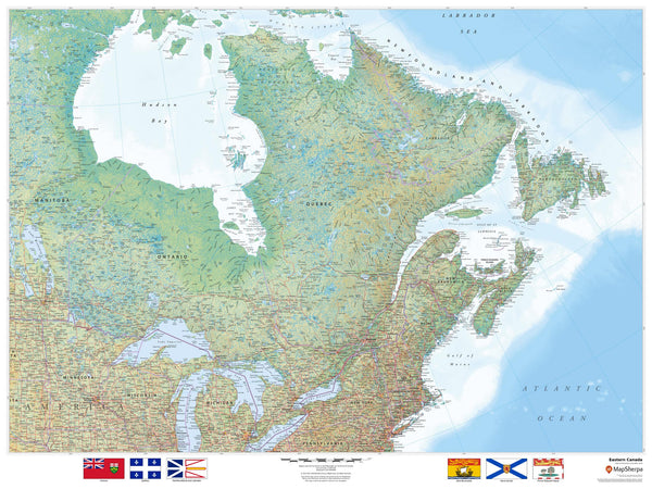
Discover the rich geography of Eastern Canada—from the St. Lawrence River and Great Lakes (eastern section) to the Appalachians, Atlantic coastline, and the rugged Canadian Shield. Clear political boundaries pair with elegant relief shading and color-by-elevation to showcase provinces, cities, waterways, and terrain in a display that’s both beautiful and informative.
🗺️ Features & Highlights
-
Comprehensive Regional Coverage: Includes Ontario, Québec, New Brunswick, Nova Scotia, Prince Edward Island, and Newfoundland & Labrador, plus surrounding areas for context.
-
Physical & Political Clarity: Provinces, boundaries, major cities (Toronto, Ottawa, Montréal, Québec City, Halifax, St. John’s), towns, highways, rail, rivers, and lakes are clearly labeled.
-
Relief Shading & Elevation Colors: Read the land at a glance—shield country, mountain chains, valleys, and coastal shelves.
-
Maritime & Inland Focus: Atlantic harbors, ferry routes (where shown), and inland water corridors along the St. Lawrence and Great Lakes region.
-
Crisp Cartography: Clean fonts and balanced labeling ideal for study, planning, or display.
✨ Available Finishes
| Format | Description |
|---|---|
| 📜 Paper (160 gsm) | Heavyweight matte-coated paper—perfect for framing under glass. |
| 🧼 Laminated (Encapsulated) | Fully sealed in 80-micron gloss laminate—durable, wipe-clean, classroom-ready. |
| 🪵 Laminated with Wooden Hang Rails | Laminated map mounted with lacquered natural timber rails (top & bottom) and a hanging cord—ready to hang. |
| 🖼️ Canvas (395 gsm) | HP Professional Matte Canvas with archival pigment inks—rich texture, fade-resistant, gallery quality. |
| 🪵 Canvas with Wooden Hang Rails | Canvas mounted with timber rails and hanging cord—timeless, ready-to-display finish (no frame required). |
🔨 Note: Hang-railed maps are custom mounted—please allow up to 10 working days.
📐 Specifications
| Feature | Detail |
|---|---|
| Title | Eastern Canada Wall Map |
| Map Type | Physical / Political |
| Scale | 1:3,000,000 |
| Dimensions | 1219 mm (W) × 914 mm (H) |
| Materials | Paper, Laminated, Canvas, with or without Timber Rails |
| Printing | Pigment-based, fade-resistant inks |
| Made In | Australia |
🎁 Perfect For
-
Homes & Offices: A striking, educational centerpiece with coastal and inland detail.
-
Classrooms & Libraries: Durable finishes for frequent reference and instruction.
-
Travel & Logistics: Plan routes and understand regional connections at a glance.
-
Collectors & Map Lovers: A premium production that balances beauty and accuracy.
🚚 Delivery
-
Paper, Laminated, Canvas (rolled): Typically ship within 1–2 business days.
-
Hang-Railed Maps: Made to order—please allow up to 10 working days.
-
Protective Packaging: Securely packed to arrive in perfect condition.
Bring Eastern Canada’s coastlines, cities, and landscapes to life on your wall—choose your finish and add to cart today.


