- Australia ▾
- Topographic
▾
- Australia AUSTopo 250k (2025)
- Australia 50k Geoscience maps
- Australia 100k Geoscience maps
- Australia 250k Geoscience maps
- Australia 1:1m Geoscience maps
- New Zealand 50k maps
- New Zealand 250k maps
- New South Wales 25k maps
- New South Wales 50k maps
- New South Wales 100k maps
- Queensland 10k maps
- Queensland 25k maps
- Queensland 50k maps
- Queensland 100k maps
- Western Australia 25k maps
- Western Australia 50k maps
- Western Australia 100k maps
- Compasses
- Software
- GPS Systems
- International ▾
- Wall Maps
▾
- World
- Australia & New Zealand
- Countries, Continents & Regions
- Historical
- Vintage National Geographic
- Australian Capital Territory
- New South Wales
- Northern Territory
- Queensland
- South Australia
- Tasmania
- Victoria
- Western Australia
- Celestial
- Children's
- Mining & Resources
- Wine Maps
- Healthcare
- Postcode Maps
- Electoral Maps
- Nautical ▾
- Flags
▾
- Australian Flag Sets & Banners
- Flag Bunting
- Handwavers
- Australian National Flags
- Aboriginal Flags
- Torres Strait Islander Flags
- International Flags
- Flagpoles & Accessories
- Australian Capital Territory Flags
- New South Wales Flags
- Northern Territory Flags
- Queensland Flags
- South Australia Flags
- Tasmania Flags
- Victoria Flags
- Western Australia Flags
- Gifts ▾
- Globes ▾
Dear valued customer. Please note that our checkout is not supported by old browsers. Please use a recent browser to access all checkout capabilities


Boston Wall Map
$69.95
or make 4 interest-free payments of
$17.49 AUD
fortnightly with
![]() More info
More info
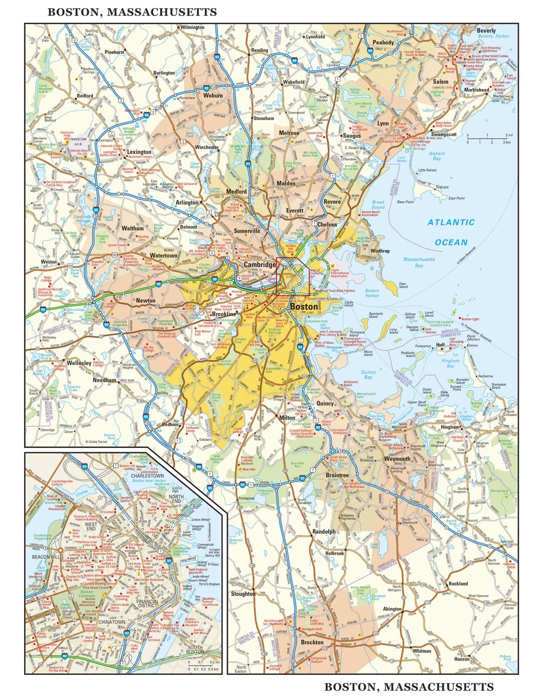
Explore the Spirit of America’s Birthplace in Stunning Detail
Few cities can claim the layered history, vibrant culture, and architectural charm of Boston. From the granite-faced townhouses of Beacon Hill to the bustling markets of Faneuil Hall, from ivy-draped Harvard Yard to the championship echoes of Fenway Park, Boston is a city where every street tells a story.
The Boston Wall Map captures that unique blend of historic gravitas and modern vitality through precise cartography and elegant design. This is more than a reference tool — it’s a work of art that brings Boston’s streets, landmarks, and surrounding landscapes to life.
📍 Two Perspectives, One Map
Regional Overview – Greater Boston at a Glance
-
Shows the full metropolitan area, including Cambridge, Quincy, Salem, and Lexington
-
Major and secondary roads, highways, and interchanges clearly marked for easy navigation
-
Parks, rivers, harbours, and the sweeping New England coastline
-
Neighbouring towns and communities for a broader geographic context
Street-Level Focus – The Beating Heart of Boston
-
High-definition inset of central Boston, from the North End to the Theatre District
-
Streets, parks, plazas, and waterfront promenades accurately plotted
-
Landmarks such as Boston Common, the Massachusetts State House, Faneuil Hall, and the Freedom Trail
-
Distinct neighbourhoods including Beacon Hill, West End, Chinatown, and Back Bay
-
Public transport links and key access points to help orient visitors and locals alike
✨ Why You’ll Love This Map
-
Dual cartography – a metropolitan overview and central Boston detail in one product
-
Shaded relief terrain – a realistic three-dimensional sense of the city’s topography
-
Elegant, timeless design – equally at home in a library, office, classroom, or living space
-
Educational & decorative – perfect for teaching geography or celebrating a connection to Boston
📐 Map Specifications
| Feature | Detail |
|---|---|
| Map Type | Regional overview + central Boston street-level inset |
| Dimensions | 1000 mm (W) x 775 mm (H) |
| Scale | Regional scale with detailed city inset |
| Publication Year | Current edition |
| Origin | Made in Australia |
| Finish Options | Paper, Laminated, Laminated with Hang Rails, Canvas, Canvas with Hang Rails |
🖌 Premium Material Options
| Format | Description |
|---|---|
| Paper (160 gsm) | High-grade matte-coated stock with sharp colour reproduction — ideal for framing under glass. |
| Laminated | Encapsulated in 80-micron gloss laminate for waterproof, tear-resistant durability. |
| Laminated with Hang Rails | Ready-to-hang with natural timber rails and cord — perfect for instant display. |
| Canvas (395 gsm) | Museum-grade HP Professional Matte Canvas with archival pigment inks — fade-resistant, richly textured, and highly durable. |
| Canvas with Hang Rails | Combines premium canvas printing with elegant, lacquered timber rails for a traditional wall-hanging look. |
🪵 Effortless Display with Timber Hang Rails
Transform your map into a statement piece with lacquered natural timber hang rails. The top rail includes a hanging cord, making installation as simple as placing a hook on the wall.
Please note: Allow up to 10 working days for hang-railed maps, as each is professionally mounted by our custom framer.
🎯 Perfect For
-
Boston natives and expatriates – a beautiful reminder of home
-
History lovers – track Boston’s Revolutionary War landmarks and historic streets
-
Educators – an engaging teaching tool for geography and history lessons
-
Travel planners – ideal for mapping itineraries and discovering neighbourhoods
-
Interior decorators – adds sophistication to living rooms, libraries, and offices
🏛 A Map Worth Framing
The Boston Wall Map is as much a decorative centrepiece as it is a geographic reference. Whether you want to trace Paul Revere’s midnight ride, find your way from Quincy Market to the Museum of Fine Arts, or simply admire the city’s elegant grid of streets, this map makes Boston’s story tangible.
Printed with archival-quality inks and materials, it is built to last — a fitting tribute to a city whose history spans nearly four centuries.
Frequently Asked Questions
What are the dimensions of the Boston Wall Map?
Mapworld wall maps range from standard 700×1000mm to large-format 1000×1430mm Supermaps. The exact dimensions for this map are shown in the product title. Where multiple sizes are available, select your preferred size when adding to cart.
Is this wall map available laminated?
Many Mapworld wall maps are available in paper, laminated, or framed finishes. Check the product options when adding to cart. Laminated maps are wipe-clean and more durable.
Is this the latest edition?
Mapworld stocks the most current editions available from all publishers. Edition year is shown in the product title where applicable. Mapworld updates its catalogue as new editions are released.
Can I write on or pin this wall map?
Laminated wall maps can be written on with whiteboard markers and wiped clean. Paper maps can be pinned on a corkboard. Choose a laminated option for a writeable surface.
Does Mapworld ship the Boston Wall Map across Australia?
Yes, Mapworld ships Australia-wide. Standard shipping is a flat $7 rate, with free standard shipping on orders over $75. Express options are available at checkout. Most orders placed before 2pm AEST on weekdays are dispatched same day.
Related Items


© 2026 Mapworld. Website designed by Genie Media
X