- Australia ▾
- Topographic
▾
- Australia AUSTopo 250k (2024)
- Australia 50k Geoscience maps
- Australia 100k Geoscience maps
- Australia 250k Geoscience maps
- Australia 1.1m Geoscience maps
- New Zealand 50k maps
- New Zealand 250k maps
- New South Wales 25k maps
- New South Wales 50k maps
- New South Wales 100k maps
- Queensland 10k maps
- Queensland 25k maps
- Queensland 50k maps
- Queensland 100k maps
- Compasses
- Software
- GPS Systems
- Orienteering
- International ▾
- Wall Maps
▾
- World
- Australia & New Zealand
- Countries, Continents & Regions
- Historical
- Vintage National Geographic
- Australian Capital Territory
- New South Wales
- Northern Territory
- Queensland
- South Australia
- Tasmania
- Victoria
- Western Australia
- Celestial
- Children's
- Mining & Resources
- Wine Maps
- Healthcare
- Postcode Maps
- Electoral Maps
- Nautical ▾
- Flags
▾
- Australian Flag Sets & Banners
- Flag Bunting
- Handwavers
- Australian National Flags
- Aboriginal Flags
- Torres Strait Islander Flags
- International Flags
- Flagpoles & Accessories
- Australian Capital Territory Flags
- New South Wales Flags
- Northern Territory Flags
- Queensland Flags
- South Australia Flags
- Tasmania Flags
- Victoria Flags
- Western Australia Flags
- Gifts ▾
- Globes ▾
Dear valued customer. Please note that our checkout is not supported by old browsers. Please use a recent browser to access all checkout capabilities
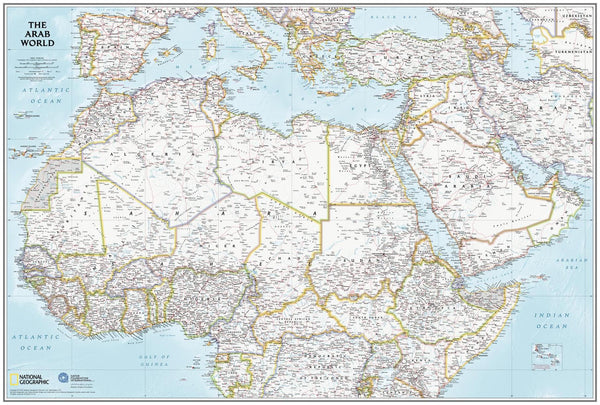
Arab World in English National Geographic Wall Map
$69.95
or make 4 interest-free payments of
$17.49 AUD
fortnightly with
![]() More info
More info
🌍 Arab World in English – National Geographic Wall Map
Scale 1:9,500,000 | Published 2019 | Regional Political & Geographic Detail
Created in partnership between National Geographic and the Qatar Foundation International, the Arab World in English Wall Map blends National Geographic’s renowned cartographic accuracy with the Qatar Foundation International’s dedication to education and cultural understanding. The result is a clear, authoritative, and visually engaging reference for one of the world’s most historically significant and geopolitically complex regions.
🗺️ Map Coverage
-
North Africa & Southern Europe – From Morocco across the Mediterranean to southern Europe.
-
Middle East & Arabian Peninsula – Includes the entire Arabian Peninsula, Turkey, and the Levant.
-
East to Iran – Full coverage extending into western Asia.
-
South to the Equator – Incorporates equatorial African nations for context.
Areas in dispute are clearly noted, with de facto borders and political status marked for reference — making it an invaluable tool for understanding both geography and geopolitics.
📐 Scale & Size Options
| Size | Dimensions |
|---|---|
| Standard | 610 mm (W) x 798 mm (H) |
| Supermap | 915 mm (W) x 1197 mm (H) |
Scale: 1:9,500,000 – ideal for classroom use, office reference, or wall display.
✨ Available Finishes
| Format | Description |
|---|---|
| 🖨️ Paper (160 gsm) | Heavyweight matte-coated paper — perfect for framing under glass. |
| 🧼 Laminated (Encapsulated) | Sealed between two sheets of 80-micron gloss laminate for a wipe-clean, tear-resistant finish. |
| 🪵 Laminated with Wooden Hang Rails | Laminated map mounted with lacquered natural timber rails (top and bottom) and a hanging cord — ready to hang. |
| 🖼️ Canvas (395 gsm) | HP Professional Matte Canvas with archival pigment-based inks. Rich texture, fade-resistant, and gallery-quality. |
| 🪵 Canvas with Wooden Hang Rails | Canvas mounted with natural timber rails and a hanging cord for a timeless, ready-to-display look. |
🔨 Please allow up to 10 working days for delivery of hang-railed maps, as these are professionally mounted by our framer.
💡 Why You’ll Love This Map
✔️ Political and geographic detail at a highly readable scale
✔️ Covers the entire Arab world with contextual regional mapping
✔️ Notes disputed areas with clarity and objectivity
✔️ Two size options — Standard and large-format Supermap
✔️ Five premium finishes to suit study, reference, or decorative use
🎯 Perfect For
-
Educators & Students – An excellent classroom resource for geography and current affairs
-
Corporate & Government Offices – For strategic and cultural reference
-
Libraries & Archives – A clear, modern political map of the Arab world
-
Home Display – For travellers, researchers, and global citizens
🚚 Delivery
-
Paper, Laminated, Canvas: Ships within 1–2 business days
-
Hang-railed Maps (Laminated or Canvas): Ships within 10 working days (custom-mounted)
-
Packaging: Rolled in a heavy-duty postal tube for safe delivery
The Arab World in English Wall Map is a comprehensive, accurate, and visually engaging reference, combining National Geographic’s cartographic expertise with a deep understanding of the region’s complexity.
👉 Order today for a high-quality map that informs, inspires, and endures.


