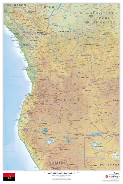
Physical & Political Detail | Shaded Relief | Premium Finishes
Explore Angola in striking clarity. This wall map blends physical geography with political boundaries, using colour-by-elevation and refined relief shading to highlight Angola’s central highlands, Atlantic coastline, major rivers (including the Cuanza and Cunene), and key cities, roads, and regions—plus surrounding context for Namibia, Zambia, the D.R. Congo, and the South Atlantic. A sophisticated, informative centerpiece for homes, offices, and classrooms.
🗺️ Features & Highlights
-
Balanced Physical + Political View: Clearly delineated provincial boundaries, cities, towns, highways, and waterways over beautifully rendered terrain.
-
Terrain at a Glance: Shaded relief and elevation colouring make mountains, plateaus, and coastal plains easy to understand from wall distance.
-
Context You Can Use: Regional coverage supports planning and study across borders—ideal for education, logistics, and travel.
-
Clean, Readable Cartography: Legible fonts and thoughtful symbology deliver a map that’s decorative yet highly functional.
✨ Available Finishes
| Format | Description |
|---|---|
| 📜 Paper (160 gsm) | Heavyweight matte-coated paper—perfect for framing under glass. |
| 🧼 Laminated (Encapsulated) | Fully sealed in 80-micron gloss laminate for a durable, wipe-clean surface—great for classrooms and busy offices. |
| 🪵 Laminated with Wooden Hang Rails | Laminated map mounted with lacquered natural timber rails (top & bottom) and a hanging cord—arrives ready to display. |
| 🖼️ Canvas (395 gsm) | HP Professional Matte Canvas with archival pigment inks—rich texture, fade-resistant, gallery quality. |
| 🪵 Canvas with Wooden Hang Rails | Canvas mounted with timber rails and hanging cord—timeless, ready-to-hang finish (no frame required). |
🔨 Note: Hang-railed maps are custom mounted—please allow up to 10 working days.
📐 Specifications
| Feature | Detail |
|---|---|
| Title | Angola Wall Map |
| Map Type | Physical & Political |
| Scale | 1:3,200,000 |
| Dimensions | 610 mm (W) × 914 mm (H) |
| Materials | Paper, Laminated, Canvas; with/without Timber Rails |
| Printing | Pigment-based, fade-resistant inks |
🎁 Perfect For
-
Education & Research: A clear reference for African geography and regional studies.
-
Home & Office Décor: A refined statement piece that informs at a glance.
-
Planning & Projects: Visualize routes, provinces, and cross-border context.
🚚 Delivery
-
Paper, Laminated, Canvas (rolled): Typically ship within 1–2 business days.
-
Hang-Railed Maps: Made to order—please allow up to 10 working days.
-
Protective Packaging: Securely packed to arrive in pristine condition.
Bring Angola’s landscapes and regions into sharp focus—choose your finish and add to cart today.


