A Historical Masterpiece from the Lady Northcote Atlas | Archival Reproduction
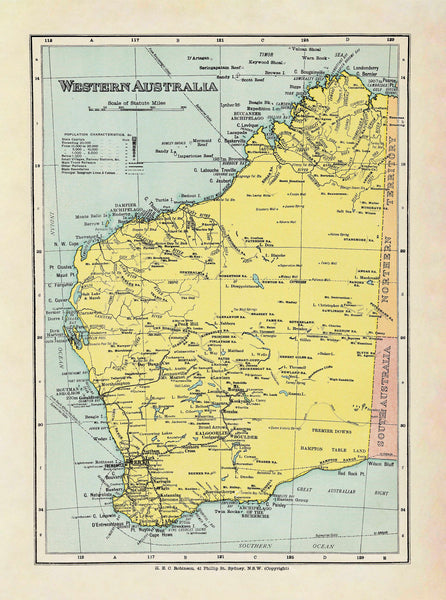
Bring history to your wall with this faithful reproduction of the Western Australia Wall Map, originally published in 1908 by H.E.C. Robinson. Enlarged from a plate in the famous Lady Northcote Atlas of Australia, this map offers a captivating window into Western Australia at the dawn of the 20th century—long before the modern highways, urban sprawl, and mining boom reshaped the state’s landscape.
A Glimpse into the Past
Crafted during a period of exploration and early federation optimism, this map reflects a time when large parts of Western Australia remained sparsely settled and only partially surveyed. Key features include:
-
Historic Borders & Settlements: See towns and regional boundaries as they were understood in 1908.
-
Elegant Period Typography: Antique typefaces and subtle colour shading evoke the style of early Australian cartography.
-
Rich Detail: Rivers, mountain ranges, deserts, and early transport routes—each captured with the precision and artistry that made Robinson one of Australia’s foremost mapmakers.
Why Choose This Map?
| Feature | Benefit |
|---|---|
| Authentic historical content | A unique record of Western Australia’s development and expansion era |
| Premium reproduction | High-resolution scanning preserves the integrity of the original plate |
| Striking vintage style | Ideal as both a historical reference and an elegant décor piece |
| Multiple formats available | Choose paper for classic framing, laminate for durability, or canvas for a premium finish |
| Made in Australia | Locally printed and finished with meticulous care |
Premium Materials & Finishes
Available in three high-quality options to suit any space:
| Format | Description |
|---|---|
| 160gsm Paper | Heavyweight matte paper perfect for framing under glass—offers archival quality at an affordable price. |
| Encapsulated Laminate | Fully sealed between two layers of 80-micron gloss laminate—durable, waterproof, and ideal for high-use spaces. |
| 395gsm Matte Canvas | Printed on museum-grade canvas using pigment-based archival inks—rich, fade-resistant colour and a tactile feel that suits homes, offices, or heritage displays. |
Timber Hang Rails
Upgrade to our timber hang rail option for the easiest display. Smooth, natural lacquered wooden battens are attached top and bottom, with a matching hanging cord. Simply add a hook or nail to the wall and your map is ready to admire.
⏳ Please allow up to 10 working days for delivery of hang-railed maps, as each piece is hand-finished by our professional framer.
Sizes & Specifications
| Attribute | Detail |
|---|---|
| Title | Western Australia Wall Map by Robinson |
| Original Publication | 1908 |
| Reproduction | Enlarged from Lady Northcote Atlas of Australia |
| Available Sizes | 660 mm (W) x 900 mm (H), 920 mm (W) x 1230 mm (H) |
| Scale | Varies (faithful to original plate) |
| Material Options | Paper, Laminated, Canvas |
| Made In | Australia |
Perfect For
-
History enthusiasts: A stunning addition to any collection of Australian heritage or colonial-era artefacts.
-
Home libraries & studies: Creates a refined atmosphere that speaks of adventure, discovery, and the evolution of Western Australia.
-
Offices & professional spaces: A striking focal point that sparks conversation and brings character to boardrooms, reception areas, or council chambers.
-
Gifts: An unforgettable present for Western Australians, history lovers, map collectors, or anyone with ties to the region.
Why Our Customers Love This Map
-
“The perfect blend of history and art. It looks incredible in our living room and everyone comments on the beautiful detail.”
-
“We bought the laminated version for our office—it’s easy to clean and incredibly durable.”
-
“A piece of Western Australian history, brilliantly reproduced and shipped with care.”
Celebrate the pioneering spirit and evolving story of Western Australia with this vintage map, faithfully reproduced and crafted to endure.
Made in Australia – Built to Last a Lifetime.


