- Australia ▾
- Topographic
▾
- Australia AUSTopo 250k (2024)
- Australia 50k Geoscience maps
- Australia 100k Geoscience maps
- Australia 250k Geoscience maps
- Australia 1.1m Geoscience maps
- New Zealand 50k maps
- New Zealand 250k maps
- New South Wales 25k maps
- New South Wales 50k maps
- New South Wales 100k maps
- Queensland 10k maps
- Queensland 25k maps
- Queensland 50k maps
- Queensland 100k maps
- Compasses
- Software
- GPS Systems
- Orienteering
- International ▾
- Wall Maps
▾
- World
- Australia & New Zealand
- Countries, Continents & Regions
- Historical
- Vintage National Geographic
- Australian Capital Territory
- New South Wales
- Northern Territory
- Queensland
- South Australia
- Tasmania
- Victoria
- Western Australia
- Celestial
- Children's
- Mining & Resources
- Wine Maps
- Healthcare
- Postcode Maps
- Electoral Maps
- Nautical ▾
- Flags
▾
- Australian Flag Sets & Banners
- Flag Bunting
- Handwavers
- Australian National Flags
- Aboriginal Flags
- Torres Strait Islander Flags
- International Flags
- Flagpoles & Accessories
- Australian Capital Territory Flags
- New South Wales Flags
- Northern Territory Flags
- Queensland Flags
- South Australia Flags
- Tasmania Flags
- Victoria Flags
- Western Australia Flags
- Gifts ▾
- Globes ▾
Dear valued customer. Please note that our checkout is not supported by old browsers. Please use a recent browser to access all checkout capabilities
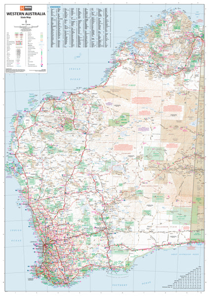
Western Australia Hema 1000 x 1430mm Supermap Laminated Wall Map with Hang Rails
$299.95
or make 4 interest-free payments of
$74.99 AUD
fortnightly with
![]() More info
More info
Western Australia — Hema Supermap (Laminated + Hang Rails)
Comprehensive State Map for Travel, Business & Planning • 1000 × 1430 mm • Scale 1:1,750,000 • Writable Laminate • Ready-to-Hang Timber Rails • Made in Australia
Discover the vast sweep of Western Australia with Hema’s exceptionally detailed, wall-readable Supermap. From remote townships to regional centres and arterial highways, this is the statewide reference trusted for trip planning, logistics, classrooms, and strategy rooms.
🗺️ Key Features
-
Complete State Coverage: Cities, towns, major & secondary roads, highways and connectors—ideal for travellers, transport operators, and planners.
-
Clear Labelling, Clean Design: Hema’s cartography prioritises across-the-room clarity with tuned line weights, calm palette, and crisp typography.
-
Interactive & Reusable: The laminated surface handles whiteboard markers and map dots—plan routes, mark service areas, then wipe clean.
🎨 Finish & Display
-
💧 True Encapsulation Lamination
Printed on 120 gsm stock and sealed in 2 × 80-micron gloss laminate (edge-sealed).
Wipe-clean • Tear-resistant • Moisture-safe — built for high-use walls. -
🪵 Timber Hang Rails — Ready to Hang
Natural lacquered timber rails (top & bottom) with a top hanging cord for a neat, professional finish—hang from a single hook.
⏱️ Custom finish: please allow up to 10 working days for rail fitting.
✅ Why Choose This Map?
-
Complete state picture: From highways to small towns, see WA at a glance.
-
Durable & writable: Update plans without wear—perfect for busy teams.
-
Effortless installation: Timber rails look sharp and save on framing time.
-
Professional quality: A trusted Hema reference for meetings, training, and briefing walls.
📐 Specifications
| Attribute | Detail |
|---|---|
| Title | Western Australia — Hema Supermap (Laminated + Hang Rails) |
| Publisher | Hema Maps |
| Scale | 1:1,750,000 |
| Size | 1000 mm (W) × 1430 mm (H) |
| Content | Towns, cities, major & secondary roads, highways |
| Finish | True encapsulation lamination + natural timber hang rails with top cord |
| Printing | High-resolution output with archival pigment inks for fade resistance |
| Lead Time | Up to 10 working days for rail fitting |
| Origin | Made in Australia |
🎯 Perfect For
-
Travel agencies & tour operators: Visual route planning and customer briefings
-
Freight & field services: Territory mapping, depot catchments, delivery windows
-
Government & councils: Statewide reference for infrastructure and engagement
-
Educators & libraries: Teaching WA geography and regional structure
-
Adventure planners: Plot outback journeys with a dependable statewide view
🤝 Our Commitment
-
Local craftsmanship: Designed, printed, laminated, and finished in Australia for consistent quality and support.
-
Clarity first: Legends, symbology, and label hierarchies tuned for wall readability in real working environments.
-
Built to last: True-encapsulation lamination resists tears, stains, and daily handling; compatible with non-permanent markers.
-
Packed with care: Each hang-railed map is hand-checked and securely boxed to arrive clean and display-ready.
Bring Western Australia’s scale and detail into your workspace—durable, legible, and ready to hang.


