- Australia ▾
- Topographic
▾
- Australia AUSTopo 250k (2025)
- Australia 50k Geoscience maps
- Australia 100k Geoscience maps
- Australia 250k Geoscience maps
- Australia 1:1m Geoscience maps
- New Zealand 50k maps
- New Zealand 250k maps
- New South Wales 25k maps
- New South Wales 50k maps
- New South Wales 100k maps
- Queensland 10k maps
- Queensland 25k maps
- Queensland 50k maps
- Queensland 100k maps
- Compasses
- Software
- GPS Systems
- Orienteering
- International ▾
- Wall Maps
▾
- World
- Australia & New Zealand
- Countries, Continents & Regions
- Historical
- Vintage National Geographic
- Australian Capital Territory
- New South Wales
- Northern Territory
- Queensland
- South Australia
- Tasmania
- Victoria
- Western Australia
- Celestial
- Children's
- Mining & Resources
- Wine Maps
- Healthcare
- Postcode Maps
- Electoral Maps
- Nautical ▾
- Flags
▾
- Australian Flag Sets & Banners
- Flag Bunting
- Handwavers
- Australian National Flags
- Aboriginal Flags
- Torres Strait Islander Flags
- International Flags
- Flagpoles & Accessories
- Australian Capital Territory Flags
- New South Wales Flags
- Northern Territory Flags
- Queensland Flags
- South Australia Flags
- Tasmania Flags
- Victoria Flags
- Western Australia Flags
- Gifts ▾
- Globes ▾
Dear valued customer. Please note that our checkout is not supported by old browsers. Please use a recent browser to access all checkout capabilities


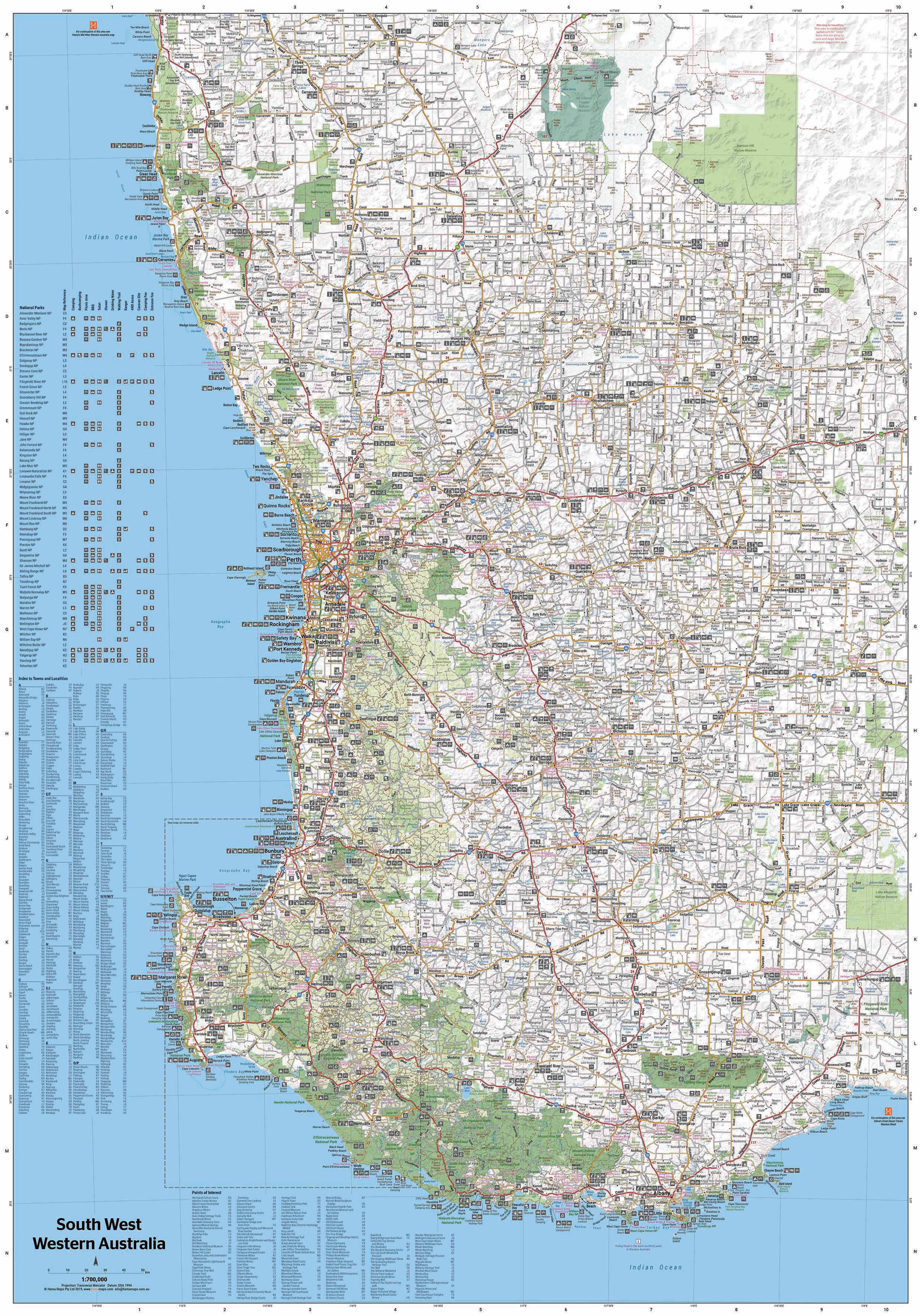
South West Western Australia Hema 1430 x 1000mm Supermap Laminated Wall Map
$149.95
or make 4 interest-free payments of
$37.49 AUD
fortnightly with
![]() More info
More info
An Oversized and Exceptionally Detailed Map for Touring, Planning & Exploring
Discover one of Australia’s most captivating regions in extraordinary detail with this supersized laminated wall map of South West Western Australia by Hema Maps. At an impressive 1430 mm x 1000 mm, this is Hema’s most comprehensive wall map of the area, combining road, 4WD track, and regional information into one high-impact format ideal for homes, offices, classrooms, or trip planning spaces.
This latest edition includes significantly expanded coverage of off-road tracks, offering far greater detail for 4WD adventurers and overland tourers than ever before. Whether you're meandering through wine country, exploring national parks, or plotting a remote escape along WA's southern coast, this is the ultimate planning companion.
🗺️ Key Features
-
Road & Track Detail:
Accurate, GPS-surveyed mapping of all major roads, regional routes, and a huge network of secondary tracks and 4WD trails. Road classifications are clearly marked for easy route planning. -
National & Regional Parks:
Green shaded park areas with inset detail for major national parks – ideal for bushwalking, nature trips, and camping. -
Camping & Caravan Facilities:
Clearly marked campgrounds, rest areas, and caravan parks across the South West. -
Tourist Icons:
Points of interest including scenic drives, geological features, waterfalls, coastal lookouts, wineries, and historical sites. -
Inset Maps:
National Park inset maps with more detail for high-interest areas.
✏️ Laminated & Ready for Use
This map is laminated using 80-micron gloss encapsulation, making it:
-
Durable and long-lasting
-
Water-resistant and easy to clean
-
Writable with whiteboard markers – plan your itinerary or mark must-see places
-
Compatible with Mark-It Dots to highlight favourite spots
Perfect for:
-
Trip planning on a kitchen or office wall
-
Caravan and 4WD enthusiasts mapping travel routes
-
Educators and businesses requiring regional reference tools
-
Tour operators and local tourism offices
📐 Specifications
| Attribute | Details |
|---|---|
| Title | South West Western Australia Supermap |
| Map Series | Hema Wall Maps |
| Scale | 1:500,000 |
| Format | Laminated Wall Map (Encapsulated) |
| Size | 1430 mm (h) × 1000 mm (w) |
| Edition | Latest release with updated 4WD tracks |
| Publisher | Hema Maps |
| Made in | Australia |
🌏 Region Coverage Includes:
-
Margaret River & the wine region
-
Albany, Denmark, and the Rainbow Coast
-
Busselton and the Geographe Bay coastline
-
Karri forests of Pemberton and Northcliffe
-
Stirling Range & Porongurup National Parks
-
Bunbury, Collie, Manjimup, Augusta & Cape Leeuwin
-
Inland towns, scenic loops, and remote tracks
Whether you're a weekend camper, a seasoned four-wheel driver, or just fascinated by Western Australia's dramatic landscapes, this map brings South West WA to life with clarity, scale, and practical detail.
Frequently Asked Questions
What are the dimensions of the South West Western Australia Hema 1430 x 1000mm Supermap Laminated Wal?
Mapworld wall maps range from standard 700×1000mm to large-format 1000×1430mm Supermaps. The exact dimensions for this map are shown in the product title. Where multiple sizes are available, select your preferred size when adding to cart.
Is this wall map available laminated?
Many Mapworld wall maps are available in paper, laminated, or framed finishes. Check the product options when adding to cart. Laminated maps are wipe-clean and more durable.
Is this the latest edition?
Mapworld stocks the most current editions available from all publishers. Edition year is shown in the product title where applicable. Mapworld updates its catalogue as new editions are released.
Can I write on or pin this wall map?
Laminated wall maps can be written on with whiteboard markers and wiped clean. Paper maps can be pinned on a corkboard. Choose a laminated option for a writeable surface.
Does Mapworld ship the South West Western Australia Hema 1430 x 1000mm Supermap Laminated Wal across Australia?
Yes, Mapworld ships Australia-wide. Standard shipping is a flat $7 rate, with free standard shipping on orders over $75. Express options are available at checkout. Most orders placed before 2pm AEST on weekdays are dispatched same day.
Related Items


© 2026 Mapworld. Website designed by Genie Media
X