- Australia ▾
- Topographic
▾
- Australia AUSTopo 250k (2025)
- Australia 50k Geoscience maps
- Australia 100k Geoscience maps
- Australia 250k Geoscience maps
- Australia 1:1m Geoscience maps
- New Zealand 50k maps
- New Zealand 250k maps
- New South Wales 25k maps
- New South Wales 50k maps
- New South Wales 100k maps
- Queensland 10k maps
- Queensland 25k maps
- Queensland 50k maps
- Queensland 100k maps
- Western Australia 25k maps
- Western Australia 50k maps
- Western Australia 100k maps
- Compasses
- Software
- GPS Systems
- International ▾
- Wall Maps
▾
- World
- Australia & New Zealand
- Countries, Continents & Regions
- Historical
- Vintage National Geographic
- Australian Capital Territory
- New South Wales
- Northern Territory
- Queensland
- South Australia
- Tasmania
- Victoria
- Western Australia
- Celestial
- Children's
- Mining & Resources
- Wine Maps
- Healthcare
- Postcode Maps
- Electoral Maps
- Nautical ▾
- Flags
▾
- Australian Flag Sets & Banners
- Flag Bunting
- Handwavers
- Australian National Flags
- Aboriginal Flags
- Torres Strait Islander Flags
- International Flags
- Flagpoles & Accessories
- Australian Capital Territory Flags
- New South Wales Flags
- Northern Territory Flags
- Queensland Flags
- South Australia Flags
- Tasmania Flags
- Victoria Flags
- Western Australia Flags
- Gifts ▾
- Globes ▾
Dear valued customer. Please note that our checkout is not supported by old browsers. Please use a recent browser to access all checkout capabilities


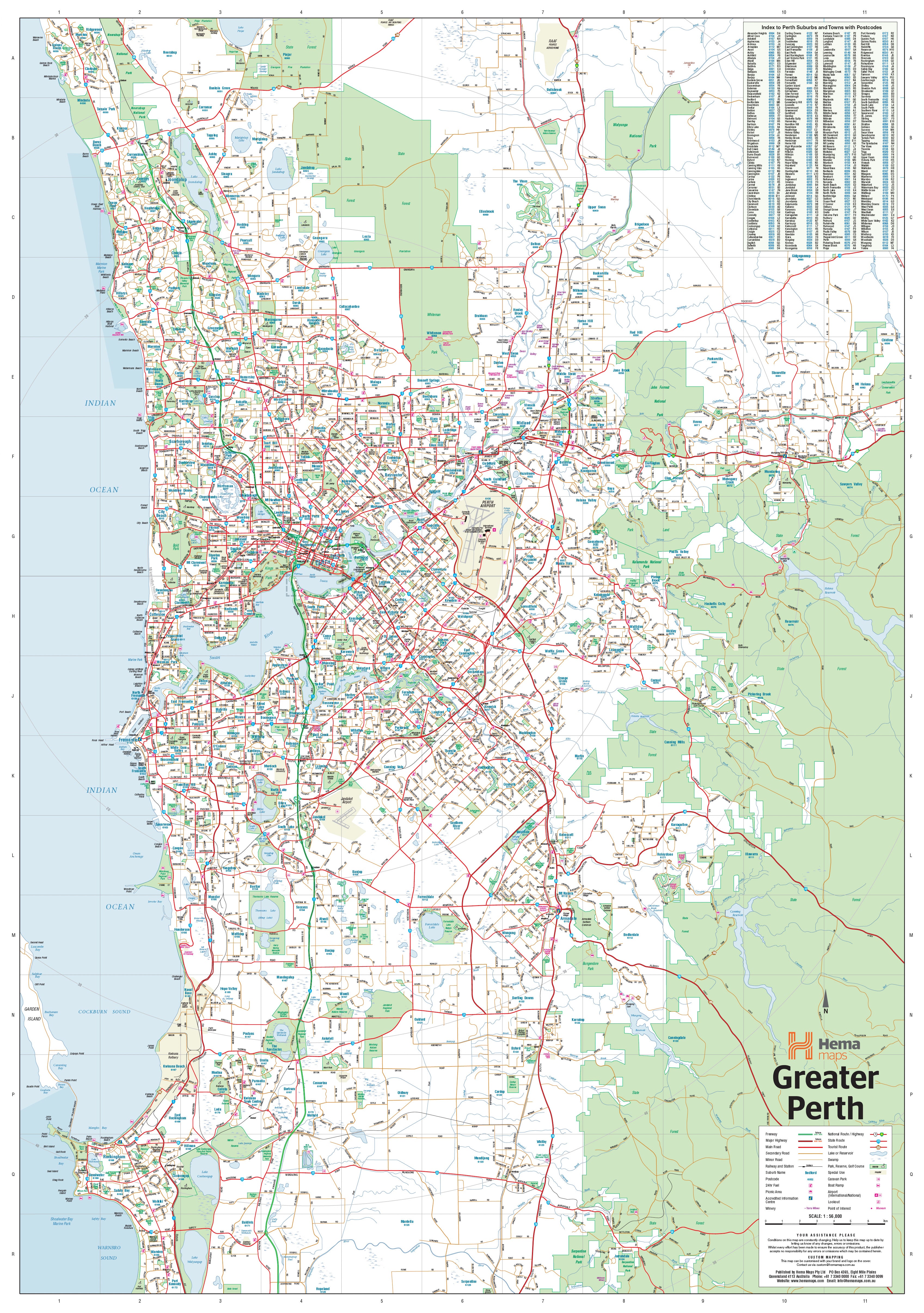

Perth & Region 700 x 1000mm Laminated Wall Map with Timber Hang Rails by Hema Maps
$225.00
or make 4 interest-free payments of
$56.25 AUD
fortnightly with
![]() More info
More info
Scale: 1:80,000 | Size: 700 mm (W) × 1000 mm (H) | Made in Australia
An elegant, functional showcase of Western Australia’s capital and coast.
🏙️ Navigate Perth in Style – From the Hills to the Indian Ocean
Immerse yourself in the beauty, precision, and utility of this Greater Perth Wall Map by Hema—an authoritative and visually captivating map that brings the Perth metropolitan region to life. Whether you're charting delivery routes, planning travel, or simply appreciating the contours of your hometown, this map is a statement piece for your wall and a powerful tool for everyday decision-making.
From the sun-drenched sands of Quinns Rocks to the tranquil waters of Safety Bay, and inland to Mundaring’s forested hills, this map captures the dynamic urban landscape, winding highways, expanding suburbs, and iconic coastlines that define Perth.
✨ Why This Map Stands Out
-
🧭 Comprehensive Metropolitan Detail
Designed with clarity and accuracy, this map features:-
Major and secondary roads
-
MET roads, state and national route numbers
-
Current and proposed freeways
-
Rail lines, major intersections, and suburb boundaries
It’s perfect for urban planning, transport logistics, sales routing, and home design.
-
-
🏘️ Postcodes Made Practical
Every suburb and postcode zone is clearly labelled—an invaluable asset for:-
Delivery teams and courier services
-
Sales reps planning territories
-
Relocation specialists and real estate agents
-
Families choosing new neighbourhoods
-
-
💎 Laminated Finish – Durable, Functional, Elegant
The map is fully encapsulated in premium 80-micron gloss laminate, offering:-
Protection from moisture, stains, and tearing
-
Write-on/wipe-off use with whiteboard markers
-
Compatibility with Map Dots to mark addresses, clients, schools, or service areas
-
-
🪵 Timber Hang Rails – Ready to Display
Mounted top and bottom with natural lacquered timber battens, your map arrives:-
Professionally finished and ready to hang
-
Equipped with a cord attached to the top rail—simply hook it on the wall
-
Stylish enough for offices, boardrooms, studios, and family homes
-
📐 Specifications
| Feature | Details |
|---|---|
| Title | Perth & Region Laminated Wall Map |
| Publisher | Hema Maps |
| Scale | 1:80,000 |
| Size | 700 mm (W) × 1000 mm (H) |
| Finish | Gloss-laminated & hang-railed (timber) |
| Map Coverage | Quinns Rocks to Safety Bay & inland to Mundaring |
| Material | 80-micron encapsulated gloss laminate |
| Hanging System | Timber battens with cord (natural lacquer) |
| Made in | Australia |
🎯 Ideal For:
-
🏢 Corporate Offices & Urban Planners
Plan infrastructure, logistics, and delivery zones with absolute clarity. -
💼 Sales Teams & Fleet Managers
Define territories and routes quickly with postcode clarity. -
🧭 Real Estate Professionals & Buyers
Understand suburb boundaries and new developments at a glance. -
🏠 Home Décor & Gifts
Add a sophisticated, meaningful touch to your home, studio, or office. -
🏫 Educators & Students
A brilliant resource for teaching WA geography, planning, and community development.
📦 Delivery Notes
Please allow up to 10 working days for delivery of this hang-railed edition, as each map is custom-mounted by our in-house framer for a perfect finish.
💬 Your Perth, Your Way – With Clarity and Craftsmanship
Whether you’re tracking a business route, showcasing your favourite suburbs, or simply celebrating the contours of the west coast’s great capital, the Perth & Region Laminated Wall Map by Hema transforms geography into a functional work of art. Precision-mapped, professionally laminated, and elegantly framed—it’s ready to guide, inspire, and impress.
Frequently Asked Questions
What are the dimensions of the Perth & Region 700 x 1000mm Laminated Wall Map with Timber Hang Rails ?
Mapworld wall maps range from standard 700×1000mm to large-format 1000×1430mm Supermaps. The exact dimensions for this map are shown in the product title. Where multiple sizes are available, select your preferred size when adding to cart.
Is this wall map available laminated?
Many Mapworld wall maps are available in paper, laminated, or framed finishes. Check the product options when adding to cart. Laminated maps are wipe-clean and more durable.
Is this the latest edition?
Mapworld stocks the most current editions available from all publishers. Edition year is shown in the product title where applicable. Mapworld updates its catalogue as new editions are released.
Can I write on or pin this wall map?
Laminated wall maps can be written on with whiteboard markers and wiped clean. Paper maps can be pinned on a corkboard. Choose a laminated option for a writeable surface.
Does Mapworld ship the Perth & Region 700 x 1000mm Laminated Wall Map with Timber Hang Rails across Australia?
Yes, Mapworld ships Australia-wide. Standard shipping is a flat $7 rate, with free standard shipping on orders over $75. Express options are available at checkout. Most orders placed before 2pm AEST on weekdays are dispatched same day.
Related Items


© 2026 Mapworld. Website designed by Genie Media
X