- Australia ▾
- Topographic
▾
- Australia AUSTopo 250k (2025)
- Australia 50k Geoscience maps
- Australia 100k Geoscience maps
- Australia 250k Geoscience maps
- Australia 1:1m Geoscience maps
- New Zealand 50k maps
- New Zealand 250k maps
- New South Wales 25k maps
- New South Wales 50k maps
- New South Wales 100k maps
- Queensland 10k maps
- Queensland 25k maps
- Queensland 50k maps
- Queensland 100k maps
- Compasses
- Software
- GPS Systems
- Orienteering
- International ▾
- Wall Maps
▾
- World
- Australia & New Zealand
- Countries, Continents & Regions
- Historical
- Vintage National Geographic
- Australian Capital Territory
- New South Wales
- Northern Territory
- Queensland
- South Australia
- Tasmania
- Victoria
- Western Australia
- Celestial
- Children's
- Mining & Resources
- Wine Maps
- Healthcare
- Postcode Maps
- Electoral Maps
- Nautical ▾
- Flags
▾
- Australian Flag Sets & Banners
- Flag Bunting
- Handwavers
- Australian National Flags
- Aboriginal Flags
- Torres Strait Islander Flags
- International Flags
- Flagpoles & Accessories
- Australian Capital Territory Flags
- New South Wales Flags
- Northern Territory Flags
- Queensland Flags
- South Australia Flags
- Tasmania Flags
- Victoria Flags
- Western Australia Flags
- Gifts ▾
- Globes ▾
Dear valued customer. Please note that our checkout is not supported by old browsers. Please use a recent browser to access all checkout capabilities


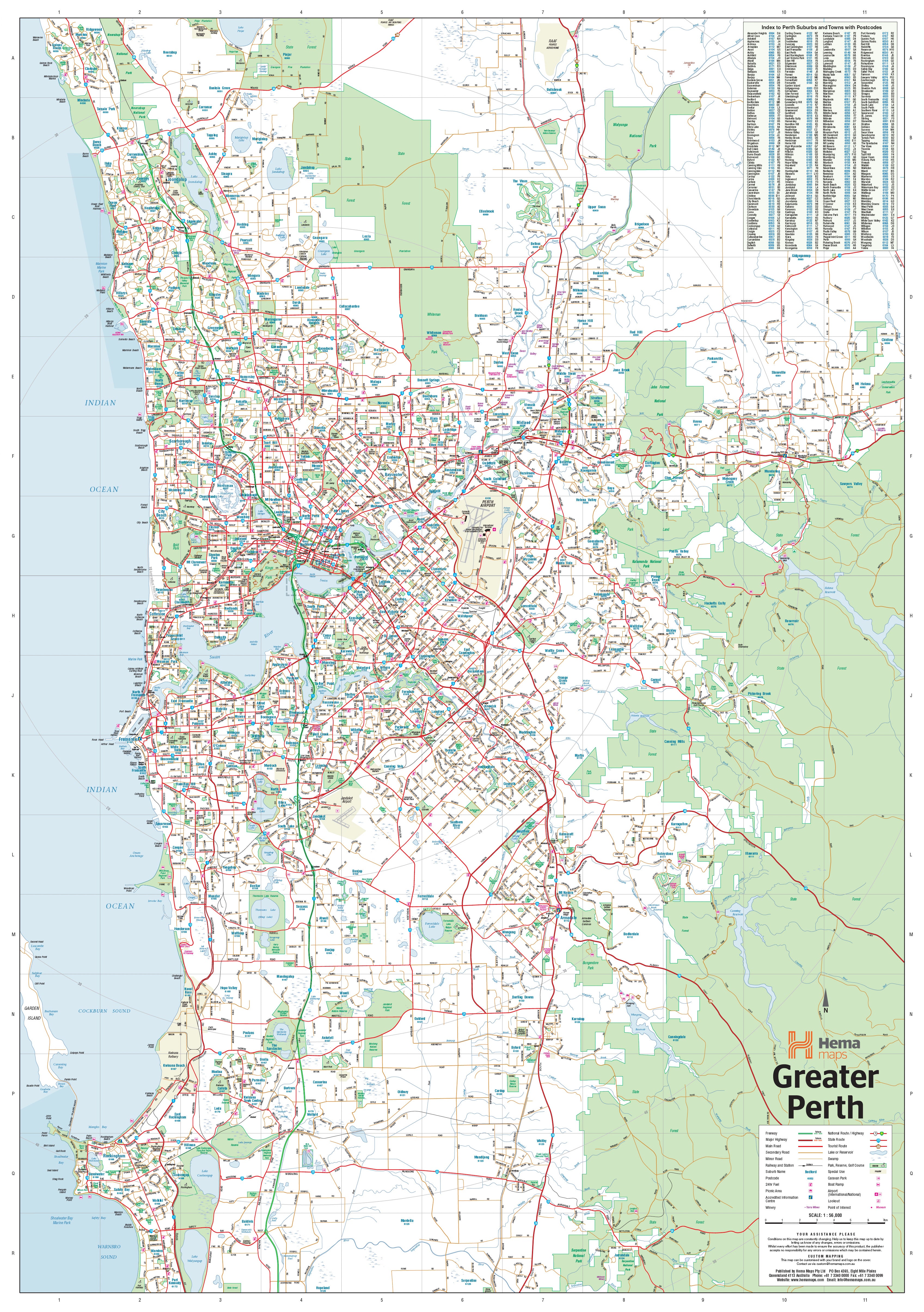

Perth & Region Hema 1000 x 1430mm Supermap Laminated Wall Map with Hang Rails
$299.95
or make 4 interest-free payments of
$74.99 AUD
fortnightly with
![]() More info
More info
Perth & Region — Hema Supermap (Laminated + Hang Rails)
1000 × 1430 mm • Scale 1:70,000 • Writable Laminate • Ready-to-Hang Timber Rails • Archival HP Pigment Inks • Made in Australia
A large-format, wall-readable map of Greater Perth—from Quinns Rocks (north) to Safety Bay (south) and east to Mundaring—built for planning, teaching, and daily decision-making. Hema’s trusted cartography presents the metro network with clear hierarchy and quietly confident design.
🗺️ Coverage & Content (At a Glance)
-
Road network clarity: Major & secondary roads with metro, national, and state route numbers
-
Future awareness: Present & future freeways indicated for long-range planning
-
Postcodes included: Perfect for sales territories, service regions, and demographic work
-
Context features: Coastal linework, key localities, and activity centres for fast orientation
🧭 Why It Works on the Wall
-
Wall-legible cartography: Calm palette, tuned line weights, and crisp typography you can read across the room
-
Clean legend & scale cues: Minimal symbology that speeds interpretation in meetings and stand-ups
-
Two-minute orientation: Find a postcode, trace a corridor, brief the team—without opening another tab
🧩 Practical Use Cases
-
Operations & logistics: Plot depot catchments, delivery windows, and response zones
-
Sales & account teams: Define postcode-based territories, store footprints, and prospecting runs
-
Property & projects: Align stakeholders on sites, access routes, and growth corridors
-
Education & community: Teach metropolitan geography and transport structure with a single, dependable visual
-
Home & office: Accurate reference that doubles as handsome wall décor
✍️ Annotation Workflow (Laminated)
-
Use non-permanent whiteboard markers for routes, zones, and notes
-
Pair with map dots or low-tack notes for multi-week planning
-
Wipe with a dry microfiber cloth (lightly damp if needed); avoid alcohol/ammonia cleaners
🎨 Finish & Display Details
-
💧 Laminated (True Encapsulation)
Printed on 120 gsm stock then sealed in 2 × 80-micron gloss laminate (edge-sealed).
Wipe-clean • Tear-resistant • Moisture-safe — built for busy walls. -
🪵 Timber Hang Rails — Ready to Hang
Natural, lacquered timber rails (top & bottom) with a top hanging cord.
Professional, tidy presentation—hang from a single hook; no framing required. -
🎨 Print Quality
Output with archival HP pigment inks for sharp linework and fade-resistant colour fidelity.
🧱 Installation & Placement Tips
-
Hang at eye level where teams congregate (war rooms, depots, meeting spaces)
-
Allow side clearance for comfortable annotation
-
If flipping between planning areas is common, keep markers and dots in a tray beneath
📦 What You Receive
-
Laminated Hema Perth & Region Supermap (double-checked for finish quality)
-
Top & bottom timber rails professionally fitted, with top hanging cord attached
📐 Specifications
| Attribute | Detail |
|---|---|
| Title | Perth & Region — Hema Supermap (Laminated + Hang Rails) |
| Dimensions | 1000 mm (W) × 1430 mm (H) |
| Scale | 1:70,000 |
| Coverage | Quinns Rocks (N) to Safety Bay (S); west to coast; east to Mundaring |
| Data Layers | Major/secondary roads; route numbers; present & future freeways; postcodes |
| Laminate | 2 × 80-micron gloss (true encapsulation), writable/wipe-clean |
| Rails | Natural timber, lacquered; top hanging cord |
| Inks | Archival HP pigment (fade-resistant) |
| Origin | Made in Australia |
| Lead Time | Custom rail finish — please allow up to 10 working days |
🤝 Our Commitment
-
Local craftsmanship: Designed, printed, laminated, and finished in Australia for consistent quality and responsive support
-
Clarity first: Legends, symbols, and label hierarchies tuned for wall readability in real working environments
-
Built to last: Robust encapsulation resists tears, stains, and daily handling; compatible with whiteboard markers
-
Packed with care: Each hang-railed map is hand-checked and securely boxed to arrive clean and display-ready
Bring Greater Perth into sharp focus—durable, legible, and ready to hang.
Frequently Asked Questions
What are the dimensions of the Perth & Region Hema 1000 x 1430mm Supermap Laminated Wall Map with Han?
Mapworld wall maps range from standard 700×1000mm to large-format 1000×1430mm Supermaps. The exact dimensions for this map are shown in the product title. Where multiple sizes are available, select your preferred size when adding to cart.
Is this wall map available laminated?
Many Mapworld wall maps are available in paper, laminated, or framed finishes. Check the product options when adding to cart. Laminated maps are wipe-clean and more durable.
Is this the latest edition?
Mapworld stocks the most current editions available from all publishers. Edition year is shown in the product title where applicable. Mapworld updates its catalogue as new editions are released.
Can I write on or pin this wall map?
Laminated wall maps can be written on with whiteboard markers and wiped clean. Paper maps can be pinned on a corkboard. Choose a laminated option for a writeable surface.
Does Mapworld ship the Perth & Region Hema 1000 x 1430mm Supermap Laminated Wall Map with Han across Australia?
Yes, Mapworld ships Australia-wide. Standard shipping is a flat $7 rate, with free standard shipping on orders over $75. Express options are available at checkout. Most orders placed before 2pm AEST on weekdays are dispatched same day.
Related Items


© 2026 Mapworld. Website designed by Genie Media
X