- Australia ▾
- Topographic
▾
- Australia AUSTopo 250k (2025)
- Australia 50k Geoscience maps
- Australia 100k Geoscience maps
- Australia 250k Geoscience maps
- Australia 1:1m Geoscience maps
- New Zealand 50k maps
- New Zealand 250k maps
- New South Wales 25k maps
- New South Wales 50k maps
- New South Wales 100k maps
- Queensland 10k maps
- Queensland 25k maps
- Queensland 50k maps
- Queensland 100k maps
- Compasses
- Software
- GPS Systems
- Orienteering
- International ▾
- Wall Maps
▾
- World
- Australia & New Zealand
- Countries, Continents & Regions
- Historical
- Vintage National Geographic
- Australian Capital Territory
- New South Wales
- Northern Territory
- Queensland
- South Australia
- Tasmania
- Victoria
- Western Australia
- Celestial
- Children's
- Mining & Resources
- Wine Maps
- Healthcare
- Postcode Maps
- Electoral Maps
- Nautical ▾
- Flags
▾
- Australian Flag Sets & Banners
- Flag Bunting
- Handwavers
- Australian National Flags
- Aboriginal Flags
- Torres Strait Islander Flags
- International Flags
- Flagpoles & Accessories
- Australian Capital Territory Flags
- New South Wales Flags
- Northern Territory Flags
- Queensland Flags
- South Australia Flags
- Tasmania Flags
- Victoria Flags
- Western Australia Flags
- Gifts ▾
- Globes ▾
Dear valued customer. Please note that our checkout is not supported by old browsers. Please use a recent browser to access all checkout capabilities


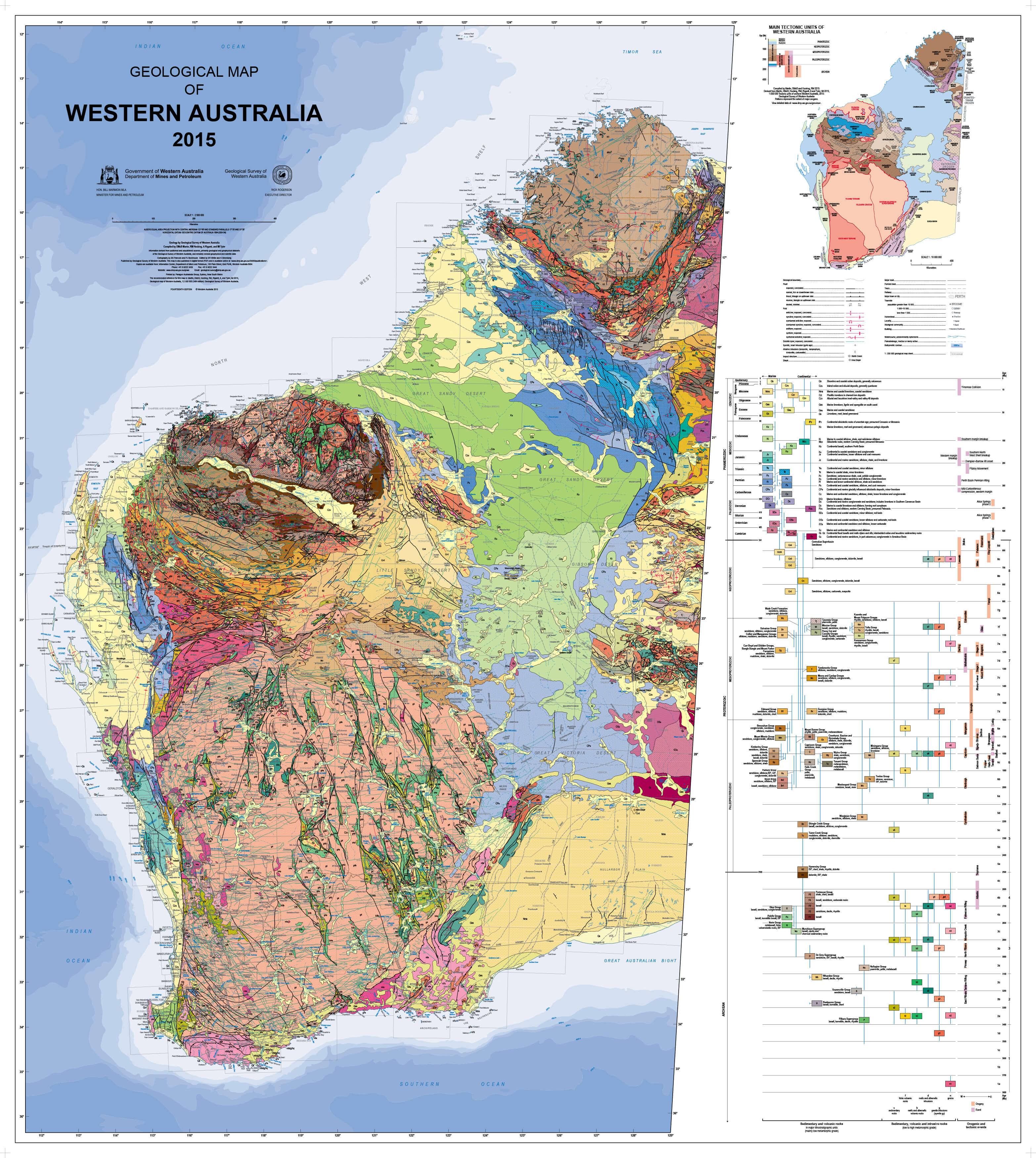
Geological Map of Western Australia 1020 x 1150mm Wall Map
$89.95
or make 4 interest-free payments of
$22.49 AUD
fortnightly with
![]() More info
More info
Geological Map of Western Australia — Wall Map
1020 × 1150 mm • Scale 1:2,500,000 • Publication: 2015 • Archival Hewlett-Packard Pigment Inks • Made in Australia
A striking, large-format geological portrait of Western Australia. This authoritative map visualises the state’s rock units and tectonic frameworks, revealing the deep-time story that shaped the Pilbara craton, Yilgarn craton, orogenic belts, basins, and margins. Whether you’re a geologist, student, or a curious mind, it’s a fascinating, wall-readable reference.
🗺️ What’s Shown
-
Rock & tectonic units: Lithologies and structural provinces rendered with clear symbology
-
Geologic ages (colour-keyed): Archean • Proterozoic (Paleo/Meso/Neo) • Paleozoic • Mesozoic • Cenozoic • Phanerozoic
-
Regional context: Major provinces, basin extents, and state-wide relationships at a glance
-
Wall-readable cartography: Balanced palette, crisp typography, and a tuned legend for quick interpretation
🎓 Who It’s For
-
Exploration & mining teams: Regional screening, province context, and stakeholder briefings
-
Universities & schools: Teaching deep time, plate tectonics, and WA’s resource geology
-
Museums, libraries & studios: A conversation-starting centrepiece with scientific depth
-
Home & office: Beautiful science—elegant enough for any wall
🎨 Materials & Finishes (Choose Your Display)
-
📄 Paper (Framing-Ready)
• Printed on FSC® 170 gsm matte-coated paper (low glare, high detail)
• Archival HP pigment inks for rich colour and fade resistance
• Ideal for framing under glass -
💧 Laminated (True Encapsulation)
• Printed on 120 gsm, sealed in 2 × 80-micron gloss laminate (edge-sealed)
• Wipe-clean, tear-resistant, moisture-safe
• Use whiteboard markers and map dots; wipe off cleanly -
🪵 Laminated + Timber Hang Rails (Ready to Hang)
• The laminated map finished with natural lacquered timber rails (top & bottom)
• Top hanging cord—hang from a single hook
• Professional, frame-free presentation
• ⏱️ Custom finish — please allow up to 10 working days -
🖼️ Canvas (Gallery-Grade)
• HP 395 gsm Professional Matte Canvas + archival HP pigment inks
• Low-glare, tactile surface; superb longevity and colour stability
• A refined, museum-style presentation -
🪵 Canvas + Timber Hang Rails (Ready to Hang)
• Same premium canvas, finished with natural timber rails + top hanging cord
• Clean, gallery aesthetic—no frame required
• ⏱️ Custom finish — please allow up to 10 working days
📐 Specifications
| Attribute | Details |
|---|---|
| Title | Geological Map of Western Australia |
| Content | Rock units & tectonic formations; colour-keyed geologic ages |
| Publication | 2015 |
| Scale | 1:2,500,000 |
| Size | 1020 mm (W) × 1150 mm (H) |
| Paper | FSC® 170 gsm matte-coated (paper version) |
| Canvas | HP 395 gsm Professional Matte (canvas versions) |
| Inks | Archival Hewlett-Packard pigment (fade-resistant) |
| Finishes | Paper • Laminated • Laminated + Hang Rails • Canvas • Canvas + Hang Rails |
| Origin | Made in Australia |
🤝 Our Commitment
-
Local craftsmanship: Designed, printed, laminated/canvas-finished in Australia for consistent quality and support.
-
Archival quality: Premium substrates and HP pigment inks for long-term clarity and colour stability.
-
Clarity first: Legends, colours, and label hierarchies tuned for wall readability in real spaces.
-
Sustainability: Paper stocks sourced from FSC®-certified supply chains.
-
Packed with care: Every map is hand-checked and securely boxed to arrive clean and display-ready.
-
Flexible options: Need branding, dedication plates, or a specific size? We’ll tailor it.
Place Western Australia’s deep-time story on your wall. Choose your finish—Paper, Laminated, Laminated + Hang Rails, Canvas, or Canvas + Hang Rails—and bring geology to life in your space.
Frequently Asked Questions
What are the dimensions of the Geological Map of Western Australia 1020 x 1150mm Wall Map?
Mapworld wall maps range from standard 700×1000mm to large-format 1000×1430mm Supermaps. The exact dimensions for this map are shown in the product title. Where multiple sizes are available, select your preferred size when adding to cart.
Is this wall map available laminated?
Many Mapworld wall maps are available in paper, laminated, or framed finishes. Check the product options when adding to cart. Laminated maps are wipe-clean and more durable.
Is this the latest edition?
Mapworld stocks the most current editions available from all publishers. Edition year is shown in the product title where applicable. Mapworld updates its catalogue as new editions are released.
Can I write on or pin this wall map?
Laminated wall maps can be written on with whiteboard markers and wiped clean. Paper maps can be pinned on a corkboard. Choose a laminated option for a writeable surface.
Does Mapworld ship the Geological Map of Western Australia 1020 x 1150mm Wall Map across Australia?
Yes, Mapworld ships Australia-wide. Standard shipping is a flat $7 rate, with free standard shipping on orders over $75. Express options are available at checkout. Most orders placed before 2pm AEST on weekdays are dispatched same day.
Related Items


© 2026 Mapworld. Website designed by Genie Media
X