- Australia ▾
- Topographic
▾
- Australia AUSTopo 250k (2025)
- Australia 50k Geoscience maps
- Australia 100k Geoscience maps
- Australia 250k Geoscience maps
- Australia 1:1m Geoscience maps
- New Zealand 50k maps
- New Zealand 250k maps
- New South Wales 25k maps
- New South Wales 50k maps
- New South Wales 100k maps
- Queensland 10k maps
- Queensland 25k maps
- Queensland 50k maps
- Queensland 100k maps
- Western Australia 25k maps
- Western Australia 50k maps
- Western Australia 100k maps
- Compasses
- Software
- GPS Systems
- International ▾
- Wall Maps
▾
- World
- Australia & New Zealand
- Countries, Continents & Regions
- Historical
- Vintage National Geographic
- Australian Capital Territory
- New South Wales
- Northern Territory
- Queensland
- South Australia
- Tasmania
- Victoria
- Western Australia
- Celestial
- Children's
- Mining & Resources
- Wine Maps
- Healthcare
- Postcode Maps
- Electoral Maps
- Nautical ▾
- Flags
▾
- Australian Flag Sets & Banners
- Flag Bunting
- Handwavers
- Australian National Flags
- Aboriginal Flags
- Torres Strait Islander Flags
- International Flags
- Flagpoles & Accessories
- Australian Capital Territory Flags
- New South Wales Flags
- Northern Territory Flags
- Queensland Flags
- South Australia Flags
- Tasmania Flags
- Victoria Flags
- Western Australia Flags
- Gifts ▾
- Globes ▾
Dear valued customer. Please note that our checkout is not supported by old browsers. Please use a recent browser to access all checkout capabilities


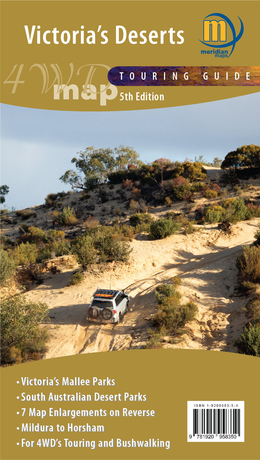
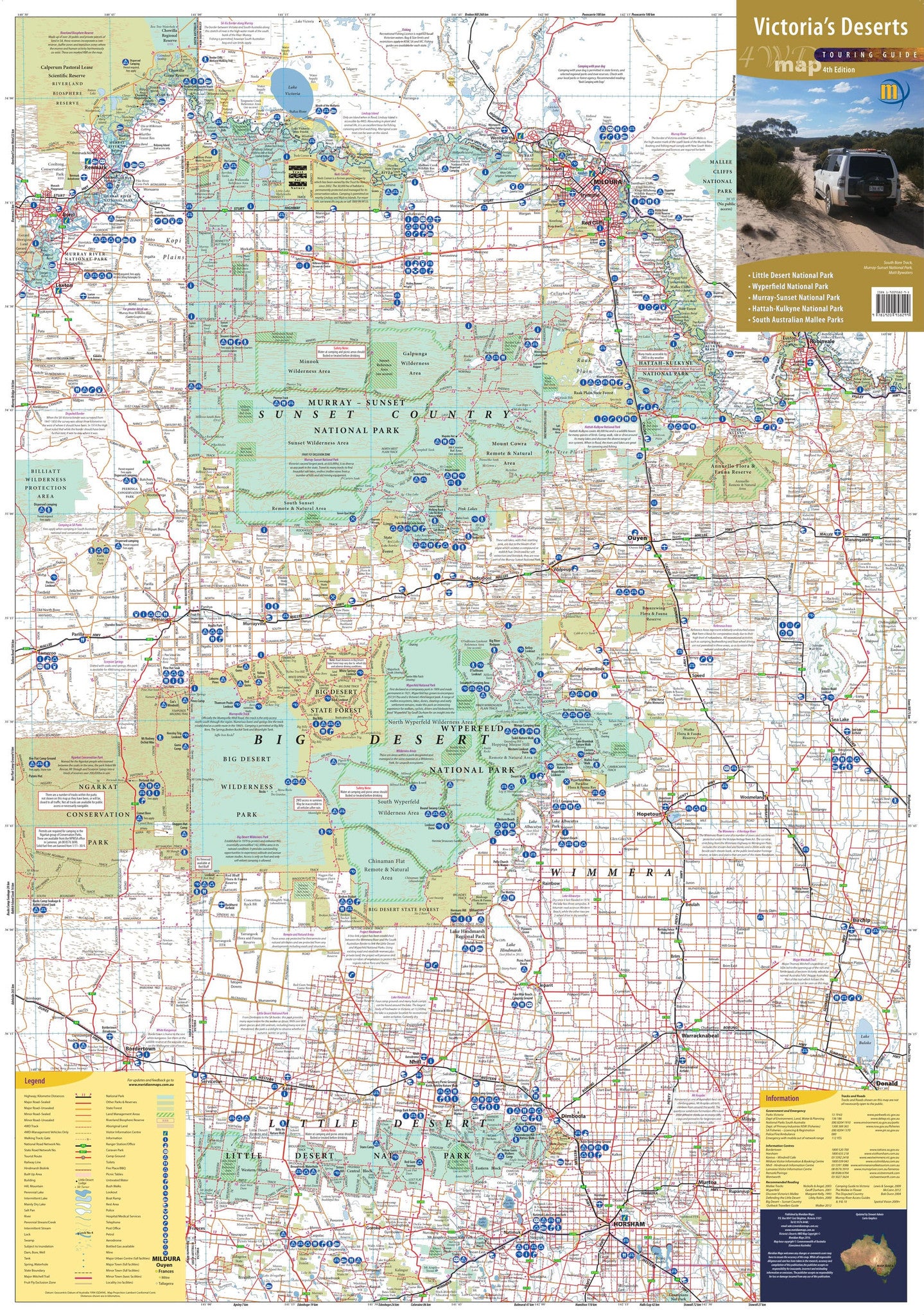
Victoria's Deserts 4WD Meridian Map
$14.95
Afterpay is only available for orders between $50.00 and $1000.00 More info
🏜️ Victoria’s Deserts 4WD Map – 4th Edition by Meridian Maps
Conquer the Remote Beauty of Victoria’s Desert Heartland
Adventure calls from the red sands and mallee scrub of northwestern Victoria — and with the Victoria’s Deserts 4WD Map – 4th Edition by Meridian, you're ready to answer it. This meticulously updated map is your ultimate off-road navigation guide to one of Australia’s most wild and underexplored regions.
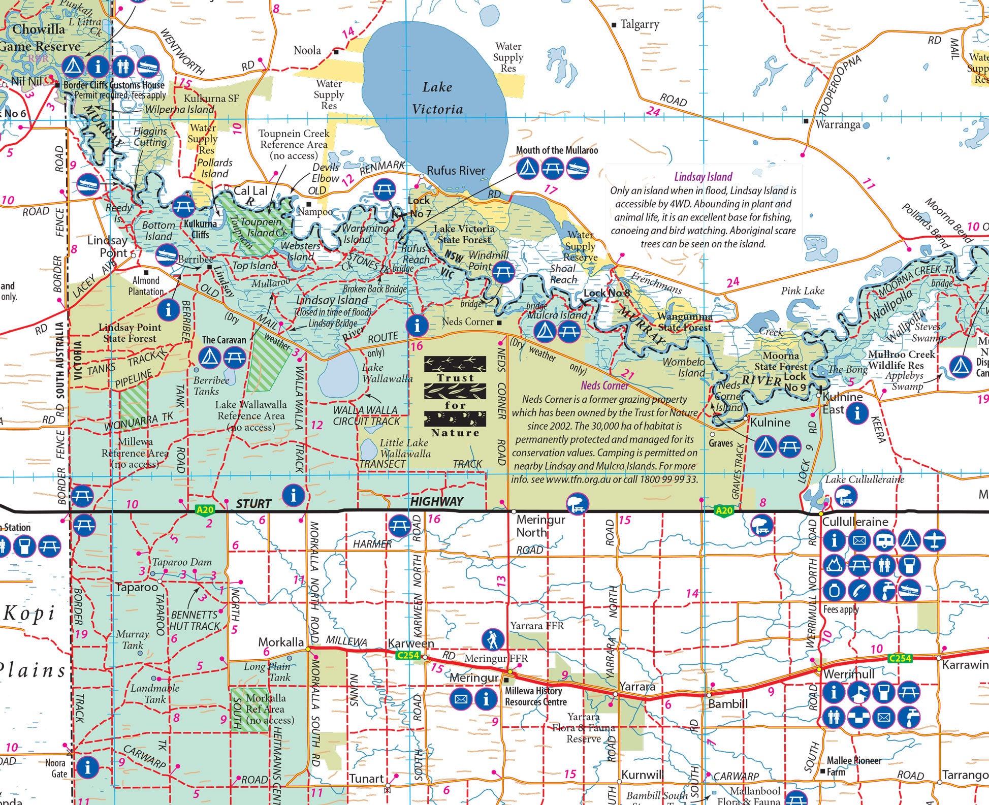
Covering the entire sweep of Victoria’s desert parks — from the Little Desert to the Murray-Sunset, and all the way across the border to South Australia’s remote reserves — this is the definitive tool for four-wheel drivers, remote campers, outback photographers, and off-grid wanderers.
🧭 What’s New in the 4th Edition
-
✅ Updated 4WD tracks & access routes
-
✅ New enlarged insets for high-interest zones
-
✅ Expanded coverage of border regions and cross-state parks
-
✅ Revised symbols and labels for better usability in the field
Whether you're tracking through Wyperfeld, navigating the Pink Lakes, or tackling the iconic Border Track, this map is built to help you do it safely, confidently, and adventurously.
🚙 Key Features & Highlights
🏞️ Covers All Major Victorian Desert Parks
-
Little Desert National Park
-
Wyperfeld National Park
-
Hattah-Kulkyne National Park
-
Big Desert State Forest
-
Murray-Sunset National Park (including the Pink Lakes)
🌵 Includes Key South Australian Desert Parks
-
Narkat Conservation Park
-
Scorpion Springs Conservation Park
Perfect for explorers tackling the Border Track or crossing between states on long-haul desert adventures.
🛻 4WD-Focused Mapping
-
All navigable 4WD tracks clearly marked
-
Shows park gates, access roads, fire trails, and detours
-
Features campgrounds, remote shelters, and facilities
📍 Tourist & Natural Features
-
Scenic lookouts, bushwalking trails, historic sites
-
Sand dunes, ephemeral lakes, salt flats, and birdwatching areas
-
Perfect for campers, walkers, stargazers, and nature photographers
🔎 Detailed Enlargements of High-Interest Zones
-
Hattah-Kulkyne National Park
-
Wyperfeld National Park
-
The Pink Lakes
-
Little Desert National Park
-
Narkat & Scorpion Springs (SA)
📐 Specifications
| Feature | Description |
|---|---|
| Scale | 1:350,000 |
| Flat Sheet Size | 1000 mm (W) × 700 mm (H) |
| Edition | 4th Edition (Latest) |
| Publisher | Meridian Maps |
| Coverage Area | Northwest Victoria & SA Border Deserts |
💎 Available Finishes
📄 Matte-Coated Paper (160 gsm)
-
Ideal for framing, planning, or folding into your glovebox
-
High-resolution printing with rich, natural colours
💧 Encapsulated Gloss Laminate (80 Micron)
-
Water-resistant, tear-proof, and field-ready
-
Writeable surface for whiteboard markers
-
Compatible with Mark-It Dots – track your past trips or plan new ones
🎯 Who This Map is Made For
| User | Benefit |
|---|---|
| 🛻 4WD & Overland Enthusiasts | Navigate Victoria’s desert parks with confidence |
| 🏕️ Campers & Bushwalkers | Discover trails, sites, and hidden landscapes |
| 🧭 Outdoor Educators & Survival Instructors | Teach in remote regions with precise, reliable mapping |
| 📷 Nature Photographers & Stargazers | Pinpoint remote camps, lakes, and starlit horizons |
| 🌄 Border Track Adventurers | Safely traverse cross-state outback terrain |
🌟 Why Choose Meridian’s Victoria’s Deserts 4WD Map?
-
🧭 Built for Remote Conditions – Trusted navigation in Australia’s harshest environments
-
🛠️ Updated and Field-Tested – Real-world usability with crystal-clear cartography
-
📐 Dual-Purpose Format – Ideal for both trip planning and in-vehicle navigation
-
🇦🇺 Proudly Australian-Made – Created by expert local cartographers who understand the terrain
🌄 Own the Map That Belongs in Every Off-Road Kit
Whether you’re heading out for a solo starlit camp in the Big Desert, chasing sunrise over the Pink Lakes, or plotting your way through the legendary Border Track, this map is your rugged, reliable, and beautifully detailed companion.
📦 Add it to your kit today — and let the desert lead the way.
🛒 Available now in paper or laminated finishes.
Made for real-world adventure. Built for those who go beyond the map.
Frequently Asked Questions
What does the Victoria's Deserts 4WD Meridian Map cover?
The Victoria's Deserts 4WD Meridian Map covers 4WD tracks, camping areas, and travel routes for the region described in the product title. Most 4WD and camping guides in Mapworld's range include GPS coordinates, distance information, difficulty ratings, and notes on fuel stops and emergency contact points.
Is the Victoria's Deserts 4WD Meridian Map up to date?
Yes, this is the current edition. Mapworld stocks current editions from publishers including Hema Maps, Westprint, and others.
Is this product suitable for remote area travel?
Yes, 4WD maps and guides are designed for remote area navigation and trip planning. They include track conditions, fuel availability, camping spots, and safety information.
Does Mapworld ship the Victoria's Deserts 4WD Meridian Map across Australia?
Yes, Mapworld ships Australia-wide. Standard shipping is a flat $7 rate, with free standard shipping on orders over $75. Express options are available at checkout. Most orders placed before 2pm AEST on weekdays are dispatched same day.
Related Items


© 2026 Mapworld. Website designed by Genie Media
X