- Australia ▾
- Topographic
▾
- Australia AUSTopo 250k (2025)
- Australia 50k Geoscience maps
- Australia 100k Geoscience maps
- Australia 250k Geoscience maps
- Australia 1:1m Geoscience maps
- New Zealand 50k maps
- New Zealand 250k maps
- New South Wales 25k maps
- New South Wales 50k maps
- New South Wales 100k maps
- Queensland 10k maps
- Queensland 25k maps
- Queensland 50k maps
- Queensland 100k maps
- Compasses
- Software
- GPS Systems
- Orienteering
- International ▾
- Wall Maps
▾
- World
- Australia & New Zealand
- Countries, Continents & Regions
- Historical
- Vintage National Geographic
- Australian Capital Territory
- New South Wales
- Northern Territory
- Queensland
- South Australia
- Tasmania
- Victoria
- Western Australia
- Celestial
- Children's
- Mining & Resources
- Wine Maps
- Healthcare
- Postcode Maps
- Electoral Maps
- Nautical ▾
- Flags
▾
- Australian Flag Sets & Banners
- Flag Bunting
- Handwavers
- Australian National Flags
- Aboriginal Flags
- Torres Strait Islander Flags
- International Flags
- Flagpoles & Accessories
- Australian Capital Territory Flags
- New South Wales Flags
- Northern Territory Flags
- Queensland Flags
- South Australia Flags
- Tasmania Flags
- Victoria Flags
- Western Australia Flags
- Gifts ▾
- Globes ▾
Dear valued customer. Please note that our checkout is not supported by old browsers. Please use a recent browser to access all checkout capabilities
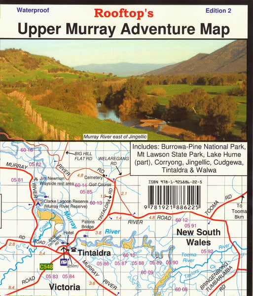
Upper Murray Adventure Map Rooftop 2nd Edition
$11.95 $12.95
Afterpay is only available for orders between $50.00 and $1000.00 More info
Topographic Touring Map | Field-Checked Tracks | 1:100,000 Scale
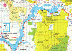
Designed for adventurers, bushwalkers, and four-wheel drivers, the Upper Murray Adventure Map by Rooftop’s is a rugged and reliable guide to one of Australia’s most scenic alpine regions. Now in its second edition, this highly detailed map provides extensive coverage of the Upper Murray and surrounding high country, with roads and tracks meticulously field-checked for accuracy.
🗺️ Map Coverage
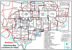
This edition covers a broad stretch of northeast Victoria and southern New South Wales, including:
-
Eastern boundary: Tintaldra
-
Western boundary: Tallangatta East
-
Northern boundary: Walwa
-
Southern boundary: Corryong
Included on the map are key towns, parklands, and natural features such as:
-
Burrowa-Pine Mountain National Park
-
Mount Lawson State Park
-
Upper reaches of Lake Hume
-
Walwa, Corryong, Tintaldra, Jingellic, Cudgewa
This is true High Country territory, filled with winding mountain roads, secluded campsites, historic huts, and lookouts that reward the adventurous.
✅ Map Features
| Feature | Details |
|---|---|
| Scale | 1:100,000 |
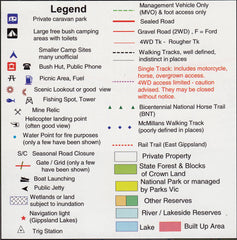
| Topographic Detail | Contours, rivers, ranges and terrain features |
| 4WD Tracks & Access Roads | Field-checked for accuracy |
| Camping & Recreation | Sites, parks, lookouts, and access points marked |
| National & State Parks | Clearly shown with park boundaries and features |
| Towns & Localities | Roads and services in Walwa, Corryong, Tintaldra and more |
🧭 Ideal For:
-
4WD touring
-
Hiking and bushwalking
-
Remote camping
-
Fishing and river access
-
Exploring historical sites and mountain huts
-
Weekend getaways and regional travel planning
🛡️ Laminated Option Available
Want added durability? Choose the laminated version, ideal for both field use and planning at home.
-
Write & wipe with whiteboard markers
-
Use our Map Dots to mark key destinations
-
Waterproof and tear-resistant
-
Laminated using high-quality 80-micron gloss film
-
Fold lines may be faintly visible due to lamination process
📐 Specifications
| Attribute | Detail |
|---|---|
| Publisher | Rooftop’s Maps |
| Edition | 2nd Edition |
| Scale | 1:100,000 |
| Material | Paper or Laminated |
| Size | Approx. 690 mm x 1000 mm |
Whether you’re seeking a quiet fishing spot on the Murray, planning a multi-day off-road route, or just exploring the valleys and peaks that make up this iconic alpine corridor, the Upper Murray Adventure Map is your go-to companion—trustworthy, detailed, and built for adventure.


