- Australia ▾
- Topographic
▾
- Australia AUSTopo 250k (2024)
- Australia 50k Geoscience maps
- Australia 100k Geoscience maps
- Australia 250k Geoscience maps
- Australia 1.1m Geoscience maps
- New Zealand 50k maps
- New Zealand 250k maps
- New South Wales 25k maps
- New South Wales 50k maps
- New South Wales 100k maps
- Queensland 10k maps
- Queensland 25k maps
- Queensland 50k maps
- Queensland 100k maps
- Compasses
- Software
- GPS Systems
- Orienteering
- International ▾
- Wall Maps
▾
- World
- Australia & New Zealand
- Countries, Continents & Regions
- Historical
- Vintage National Geographic
- Australian Capital Territory
- New South Wales
- Northern Territory
- Queensland
- South Australia
- Tasmania
- Victoria
- Western Australia
- Celestial
- Children's
- Mining & Resources
- Wine Maps
- Healthcare
- Postcode Maps
- Electoral Maps
- Nautical ▾
- Flags
▾
- Australian Flag Sets & Banners
- Flag Bunting
- Handwavers
- Australian National Flags
- Aboriginal Flags
- Torres Strait Islander Flags
- International Flags
- Flagpoles & Accessories
- Australian Capital Territory Flags
- New South Wales Flags
- Northern Territory Flags
- Queensland Flags
- South Australia Flags
- Tasmania Flags
- Victoria Flags
- Western Australia Flags
- Gifts ▾
- Globes ▾
Dear valued customer. Please note that our checkout is not supported by old browsers. Please use a recent browser to access all checkout capabilities
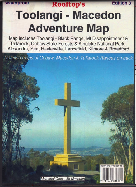
Toolangi - Macedon Adventure Map Rooftop
$12.95 $13.95
Afterpay is only available for orders between $50.00 and $1000.00 More info
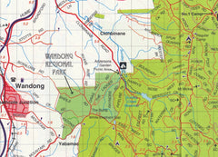
The ultimate outdoor navigation companion for bushwalkers, 4WD explorers, and nature lovers in Victoria’s Central Highlands.
Whether you're planning a weekend hike, a 4WD adventure, or a scenic forest escape, the Toolangi–Macedon Adventure Map by Rooftop Maps delivers the accuracy, local knowledge, and rugged detail you need. This expertly crafted topographic map combines years of fieldwork, GPS mapping, and community insight into one of the most comprehensive recreational maps available for the region.
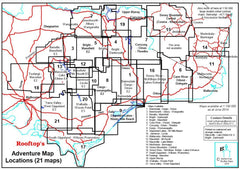
Covering a vast swathe of Victoria’s forested ranges and rural towns, this map is packed with updated information on track conditions, fire access routes, campgrounds, lookouts, facilities, and safety notices. Designed for serious explorers, it’s an essential guide to discovering both popular and off-the-beaten-track destinations.
🧭 Map Features & Highlights
-
Scale: 1:100,000 (main map)
-
Contours: Elevation lines for clear topographic context
-
Map Edition: Latest field-checked version by Rooftop Maps
-
Format: Folded paper (lamination optional)
-
Size (unfolded): 700 mm (W) × 1000 mm (H)
🌄 Coverage Area
Spanning Alexandra, Narbethong, and Buxton in the east to Cobaw, Lancefield, Macedon, and Romsey in the west, the map includes:
-
Toolangi State Forest
-
Mount Disappointment State Forest
-
Cobaw Ranges
-
Tallarook State Forest
-
Black Range
-
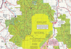
Kinglake National Park
-
Healesville, Murrindindi, Seymour, Yea, and more
This is one of the most diverse and ecologically rich corners of Victoria, making it ideal for outdoor enthusiasts.
🗺️ Reverse Side Enlargements
The reverse side includes detailed 1:50,000 scale insets for focused exploration:
-
Macedon Ranges Forest Activities Map
-
Cobaw Ranges Forest Activities Map
-
Tallarook Forest Activities Map
Each enlargement includes:
-
Track classifications and access information
-
Contours for elevation reference
-
Amenities such as toilets, picnic grounds, car parks, and campgrounds
-
Fire access roads and safety reference points
🚙 Adventure-Ready Detail
-
Over 5000 km of roads and 4WD tracks, plotted with GPS accuracy
-
Suggested lookouts, walking trails, and scenic drives
-
Visitor tips, including facility opening hours, hazard notes, and seasonal closures
-
Historical and recreational landmarks
-
All parks, reserves, and forest areas clearly marked
-
Ideal for planning bushwalking, trail running, mountain biking, or camping weekends
🧱 Optional Lamination
For rugged use, we offer this map laminated between 80-micron gloss plastic, making it:
-
💧 Waterproof & tear-resistant
-
✏️ Writable with non-permanent markers (great for route planning)
-
💼 Rollable and durable for long-term field use
Use it on the bonnet, at the campsite, or pinned up in your trip-planning area.
🎯 Perfect For:
-
🧭 Bushwalkers & Hikers tackling forest loops and ridge trails
-
🚙 4WD Adventurers exploring challenging off-road terrain
-
🏕️ Campers & Day-Trippers looking for secluded spots
-
🐦 Nature Lovers seeking waterfalls, wildflowers, and wildlife
-
🌲 Forest School Educators & Scouts teaching navigation and outdoor skills
-
🧳 Weekend explorers looking to get off-grid in the Victorian high country
🌿 Discover Victoria’s Forested Heart
From misty gullies and fern glades to rugged escarpments and rocky lookouts, the Toolangi–Macedon region is one of Victoria’s most varied and visually spectacular landscapes. With the trusted detail of Rooftop Maps, you’ll travel with local insight, expert navigation, and complete confidence.
Navigate deeper. Camp smarter. Explore further — with Rooftop.


