- Australia ▾
- Topographic
▾
- Australia AUSTopo 250k (2025)
- Australia 50k Geoscience maps
- Australia 100k Geoscience maps
- Australia 250k Geoscience maps
- Australia 1:1m Geoscience maps
- New Zealand 50k maps
- New Zealand 250k maps
- New South Wales 25k maps
- New South Wales 50k maps
- New South Wales 100k maps
- Queensland 10k maps
- Queensland 25k maps
- Queensland 50k maps
- Queensland 100k maps
- Western Australia 25k maps
- Western Australia 50k maps
- Western Australia 100k maps
- Compasses
- Software
- GPS Systems
- International ▾
- Wall Maps
▾
- World
- Australia & New Zealand
- Countries, Continents & Regions
- Historical
- Vintage National Geographic
- Australian Capital Territory
- New South Wales
- Northern Territory
- Queensland
- South Australia
- Tasmania
- Victoria
- Western Australia
- Celestial
- Children's
- Mining & Resources
- Wine Maps
- Healthcare
- Postcode Maps
- Electoral Maps
- Nautical ▾
- Flags
▾
- Australian Flag Sets & Banners
- Flag Bunting
- Handwavers
- Australian National Flags
- Aboriginal Flags
- Torres Strait Islander Flags
- International Flags
- Flagpoles & Accessories
- Australian Capital Territory Flags
- New South Wales Flags
- Northern Territory Flags
- Queensland Flags
- South Australia Flags
- Tasmania Flags
- Victoria Flags
- Western Australia Flags
- Gifts ▾
- Globes ▾
Dear valued customer. Please note that our checkout is not supported by old browsers. Please use a recent browser to access all checkout capabilities


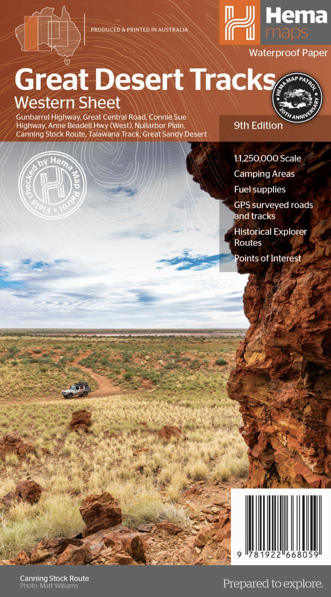
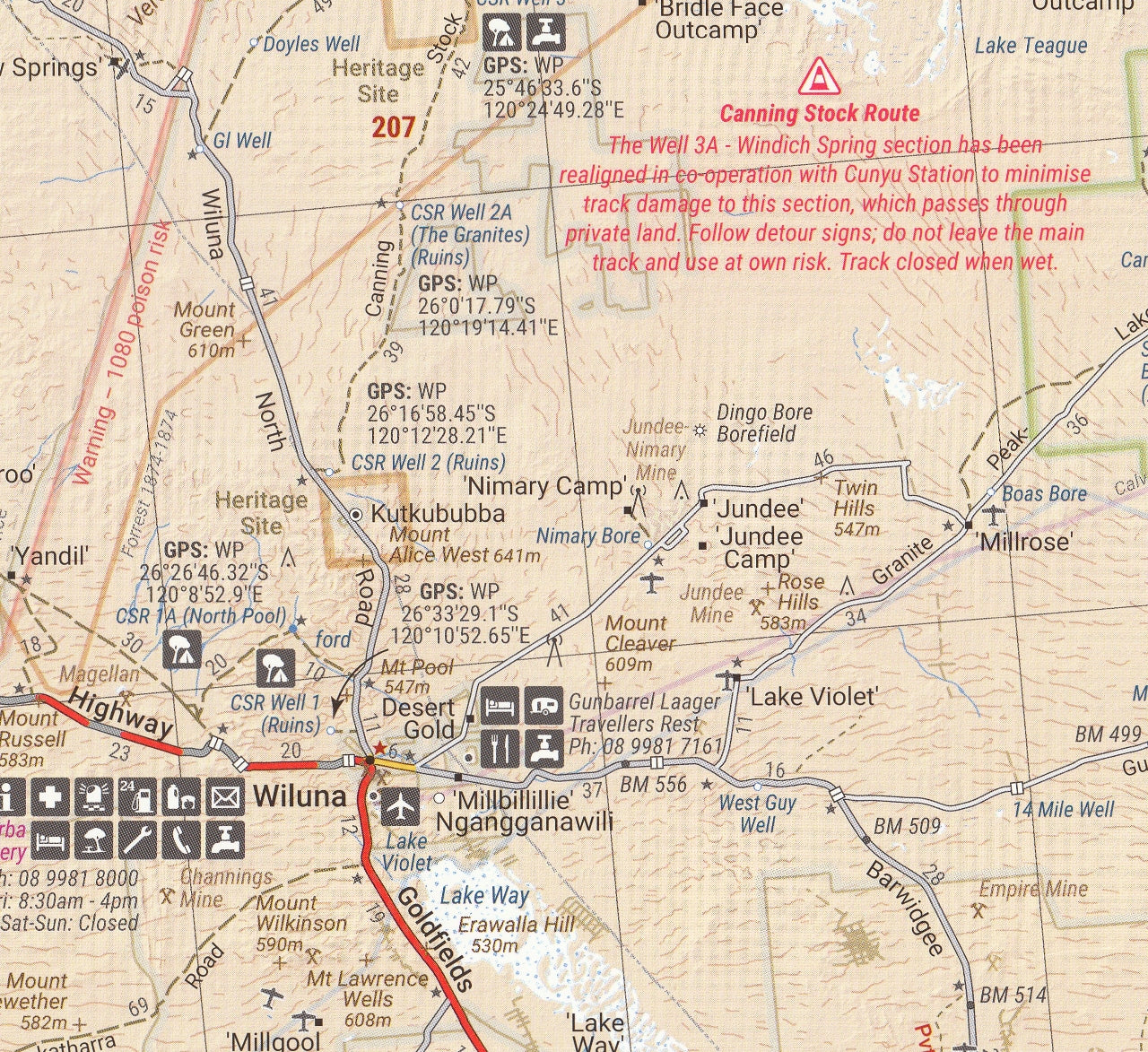
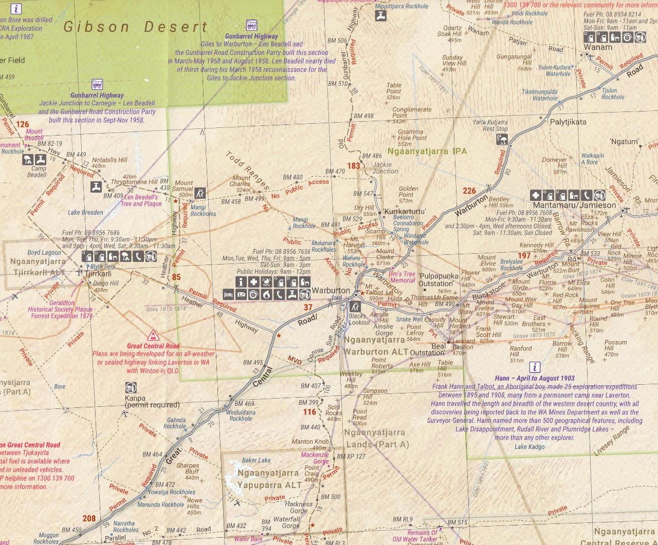
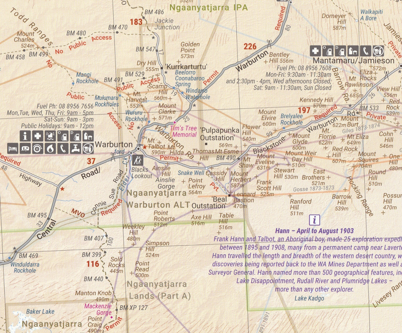
Great Desert Tracks Western Sheet Hema Map
$14.95
Afterpay is only available for orders between $50.00 and $1000.00 More info
A rugged, reliable companion for exploring Western Australia’s most remote and legendary 4WD routes.
The Great Desert Tracks Western Sheet by Hema Maps is an indispensable navigation tool for adventurers looking to tackle the arid heart of Western Australia. Whether you're traversing the historic Gunbarrel Highway, journeying along the Canning Stock Route, or venturing into the vast Great Sandy Desert, this map provides the critical detail, GPS accuracy, and topographic insight you need to plan and execute a safe and rewarding outback expedition.
Painstakingly compiled and field-checked by the Hema Map Patrol, the Western Sheet is one of four maps in Hema’s acclaimed Great Desert Tracks series, trusted by off-roaders, explorers, and expedition planners across Australia.
🗺️ Coverage Overview
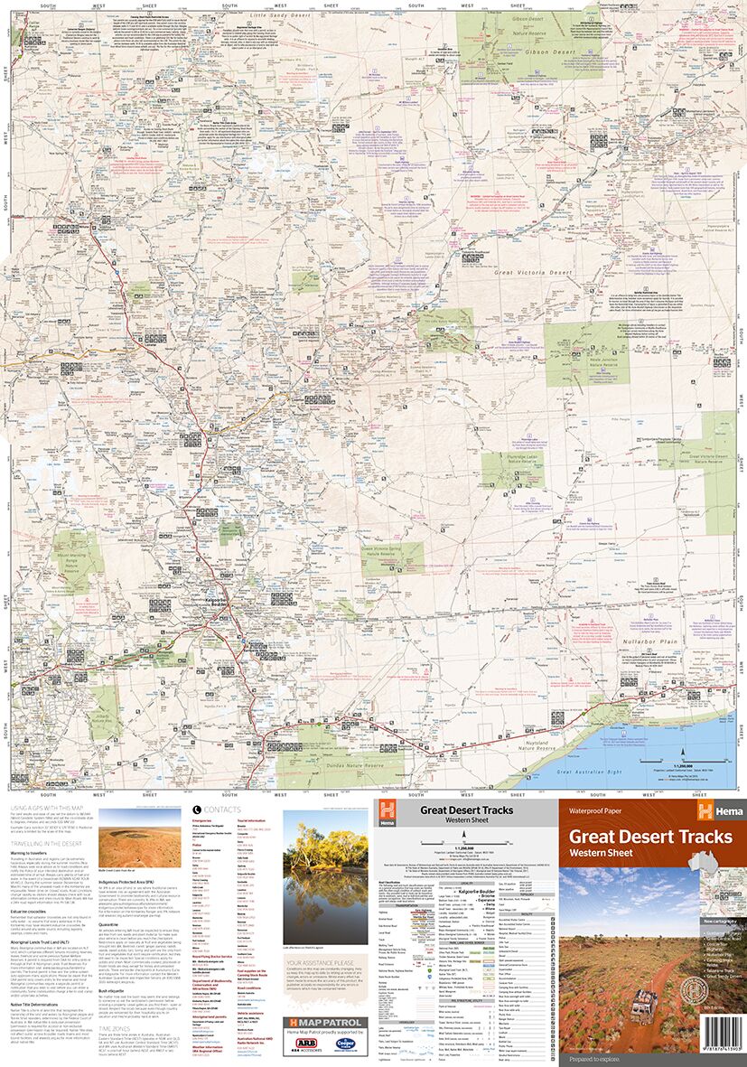
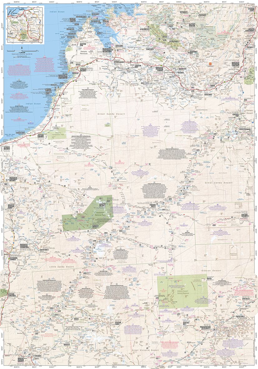
The Western Sheet offers expansive and thorough coverage of the desert regions of Western Australia, from the Kimberley and Pilbara down to the Nullarbor Plain. Key areas include:
-
Northern boundary: Beyond Derby, including Broome, Halls Creek, and Fitzroy Crossing
-
Southern boundary: Extends down past Norseman and across the Nullarbor
-
Eastern boundary: Includes parts of the NT/WA border, linking to the Central Sheet
-
Western boundary: From Port Hedland to the coast near Exmouth
This makes the Western Sheet ideal for cross-regional and multi-week expeditions.
🧭 Featured Tracks & Routes
This map includes many of Western Australia’s most iconic and remote routes:
-
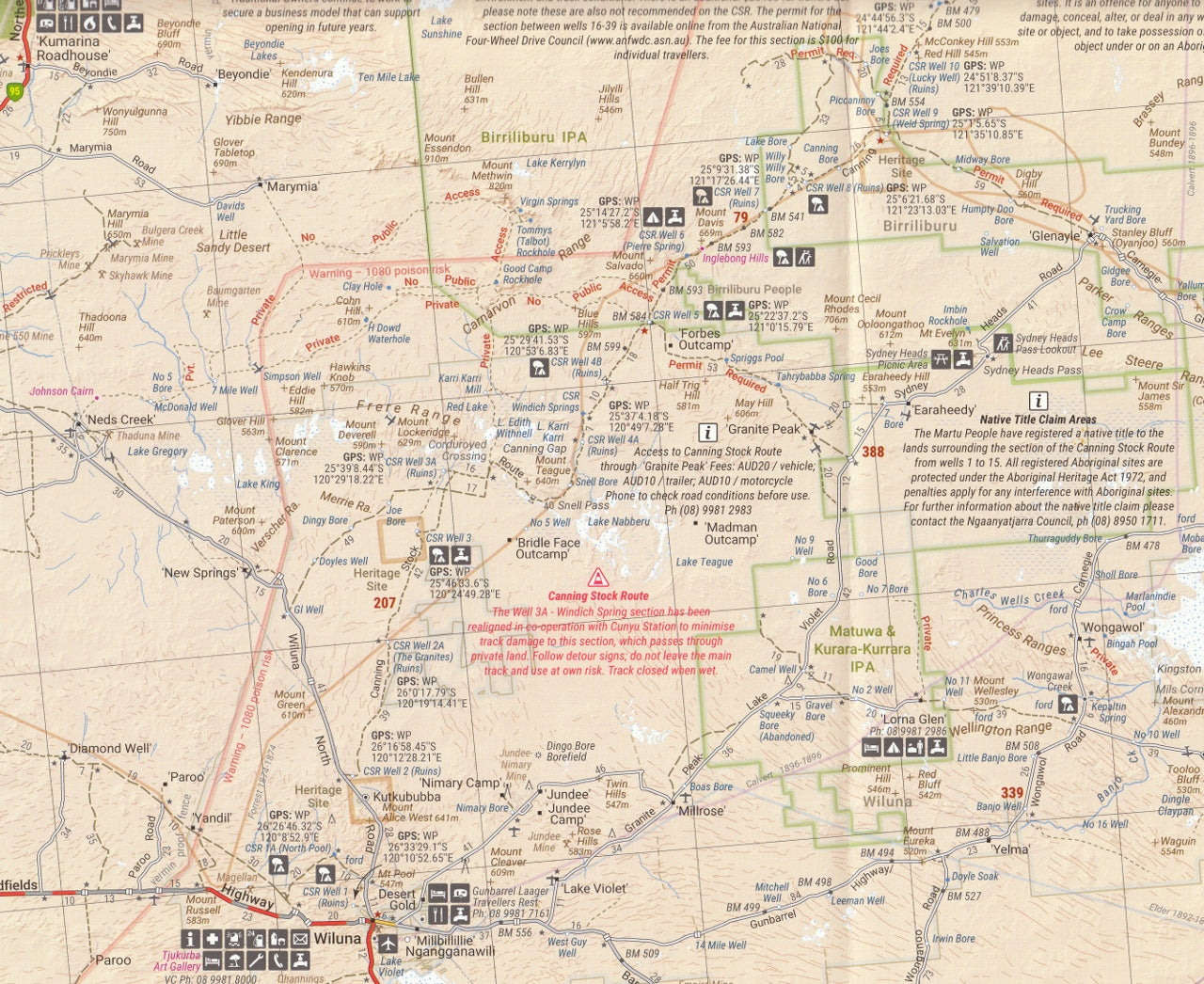
Canning Stock Route – Australia’s most challenging 4WD track, stretching 1,850 km through remote desert terrain
-
Gunbarrel Highway – Legendary track pioneered by Len Beadell, connecting Wiluna to Warburton
-
Talawana Track – A lesser-known route that intersects the CSR and offers dramatic outback landscapes
-
Connie Sue Highway – A remote route linking Rawlinna to Warburton
-
Anne Beadell Highway (Western segment) – Rugged, beautiful, and steeped in outback exploration history
-
Great Central Road – A more accessible route, suitable for well-prepared touring vehicles
-
David Carnegie Road, Heather Highway, and many minor connectors
-
Remote regions like the Little Sandy Desert, Great Victoria Desert, and Great Sandy Desert
🧭 Map Features
-
Scale: 1:1,250,000 – ideal for route planning with sufficient topographic reference
-
Relief Shading: Indicates elevation and terrain shape
-
Road Classifications: Clearly marks sealed, unsealed, and 4WD-only tracks
-
Distances: Key travel distances marked between waypoints
-
Fuel & Facilities:
-
24-hour and remote fuel stops
-
Campsites, roadhouses, bore locations
-
Aboriginal communities and restricted access areas
-
-
GPS-surveyed Data: Ensures high accuracy of roads and tracks
-
Touring Symbols: Identify key points of interest, including ruins, scenic lookouts, and emergency services
📐 Product Details
-
Edition: 9th Edition
-
Published: 15 June 2022
-
Flat Size: 1000 mm × 700 mm
-
Folded Size: 140 mm × 250 mm
-
Weight: Approx. 55 grams
-
Material: Waterproof Papaer or Laminated
-
Format: Double-sided, colour map with extensive legend and route notes
-
ISBN: 9781925625809
🏕️ Ideal For:
-
4WD enthusiasts and overlanders: Tackle remote desert crossings with confidence
-
Expedition planners: Map long-distance, multi-week treks through complex desert systems
-
Outback travellers: Navigate lesser-known desert routes with ease
-
Remote area explorers: Use as a backup to GPS or as a primary navigation aid in no-signal zones
-
Off-grid adventurers: Identify water sources, bores, fuel stops, and terrain hazards
Also available as part of the Great Desert Tracks Map Pack, which includes the Central, Eastern, and Simpson Desert Sheets in a protective wallet.
🧭 Why Choose the Hema Great Desert Tracks Series?
-
Trusted by experts: Australia’s premier desert and outback maps
-
Updated regularly with GPS-verified content
-
Ideal for both novice and seasoned outback explorers
-
Designed by travellers—for travellers
✅ Summary
The Hema Great Desert Tracks Western Sheet is the definitive printed guide to the wild western deserts of Australia. Whether you're crossing the Canning, camping beneath the Milky Way in the Gibson Desert, or tracing Len Beadell's pioneering routes, this map will be your go-to tool for adventure, safety, and exploration.
Don’t head west without it.
Map the unknown. Travel with Hema.
Frequently Asked Questions
What does the Great Desert Tracks Western Sheet Hema Map cover?
The Great Desert Tracks Western Sheet Hema Map covers 4WD tracks, camping areas, and travel routes for the region described in the product title. Most 4WD and camping guides in Mapworld's range include GPS coordinates, distance information, difficulty ratings, and notes on fuel stops and emergency contact points.
Is the Great Desert Tracks Western Sheet Hema Map up to date?
Yes, this is the current edition. Mapworld stocks current editions from publishers including Hema Maps, Westprint, and others.
Is this product suitable for remote area travel?
Yes, 4WD maps and guides are designed for remote area navigation and trip planning. They include track conditions, fuel availability, camping spots, and safety information.
Does Mapworld ship the Great Desert Tracks Western Sheet Hema Map across Australia?
Yes, Mapworld ships Australia-wide. Standard shipping is a flat $7 rate, with free standard shipping on orders over $75. Express options are available at checkout. Most orders placed before 2pm AEST on weekdays are dispatched same day.
Related Items


© 2026 Mapworld. Website designed by Genie Media
X