- Australia ▾
- Topographic
▾
- Australia AUSTopo 250k (2025)
- Australia 50k Geoscience maps
- Australia 100k Geoscience maps
- Australia 250k Geoscience maps
- Australia 1:1m Geoscience maps
- New Zealand 50k maps
- New Zealand 250k maps
- New South Wales 25k maps
- New South Wales 50k maps
- New South Wales 100k maps
- Queensland 10k maps
- Queensland 25k maps
- Queensland 50k maps
- Queensland 100k maps
- Western Australia 25k maps
- Western Australia 50k maps
- Western Australia 100k maps
- Compasses
- Software
- GPS Systems
- International ▾
- Wall Maps
▾
- World
- Australia & New Zealand
- Countries, Continents & Regions
- Historical
- Vintage National Geographic
- Australian Capital Territory
- New South Wales
- Northern Territory
- Queensland
- South Australia
- Tasmania
- Victoria
- Western Australia
- Celestial
- Children's
- Mining & Resources
- Wine Maps
- Healthcare
- Postcode Maps
- Electoral Maps
- Nautical ▾
- Flags
▾
- Australian Flag Sets & Banners
- Flag Bunting
- Handwavers
- Australian National Flags
- Aboriginal Flags
- Torres Strait Islander Flags
- International Flags
- Flagpoles & Accessories
- Australian Capital Territory Flags
- New South Wales Flags
- Northern Territory Flags
- Queensland Flags
- South Australia Flags
- Tasmania Flags
- Victoria Flags
- Western Australia Flags
- Gifts ▾
- Globes ▾
Dear valued customer. Please note that our checkout is not supported by old browsers. Please use a recent browser to access all checkout capabilities


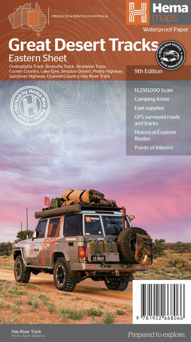
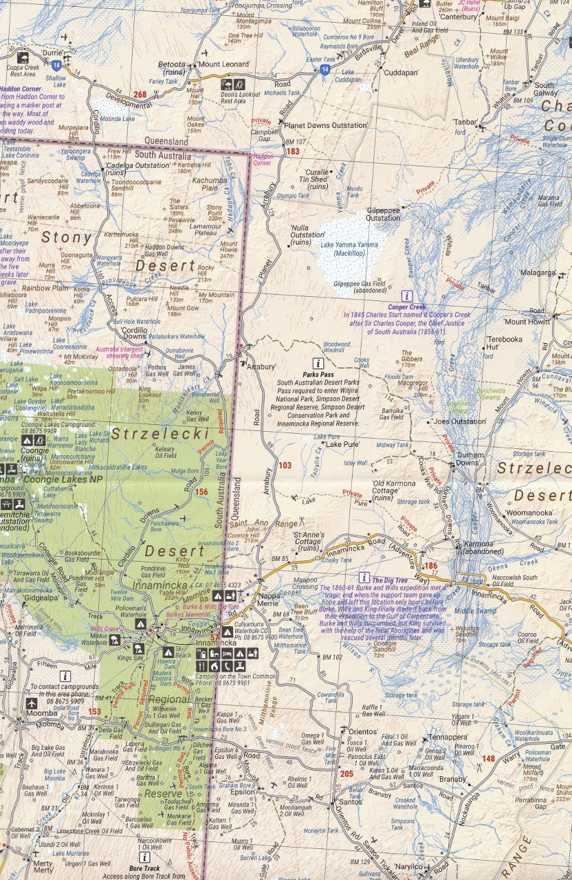
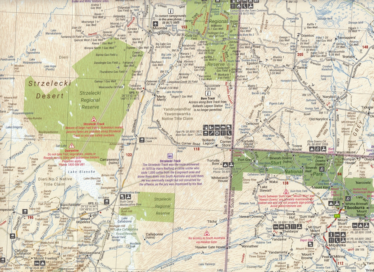
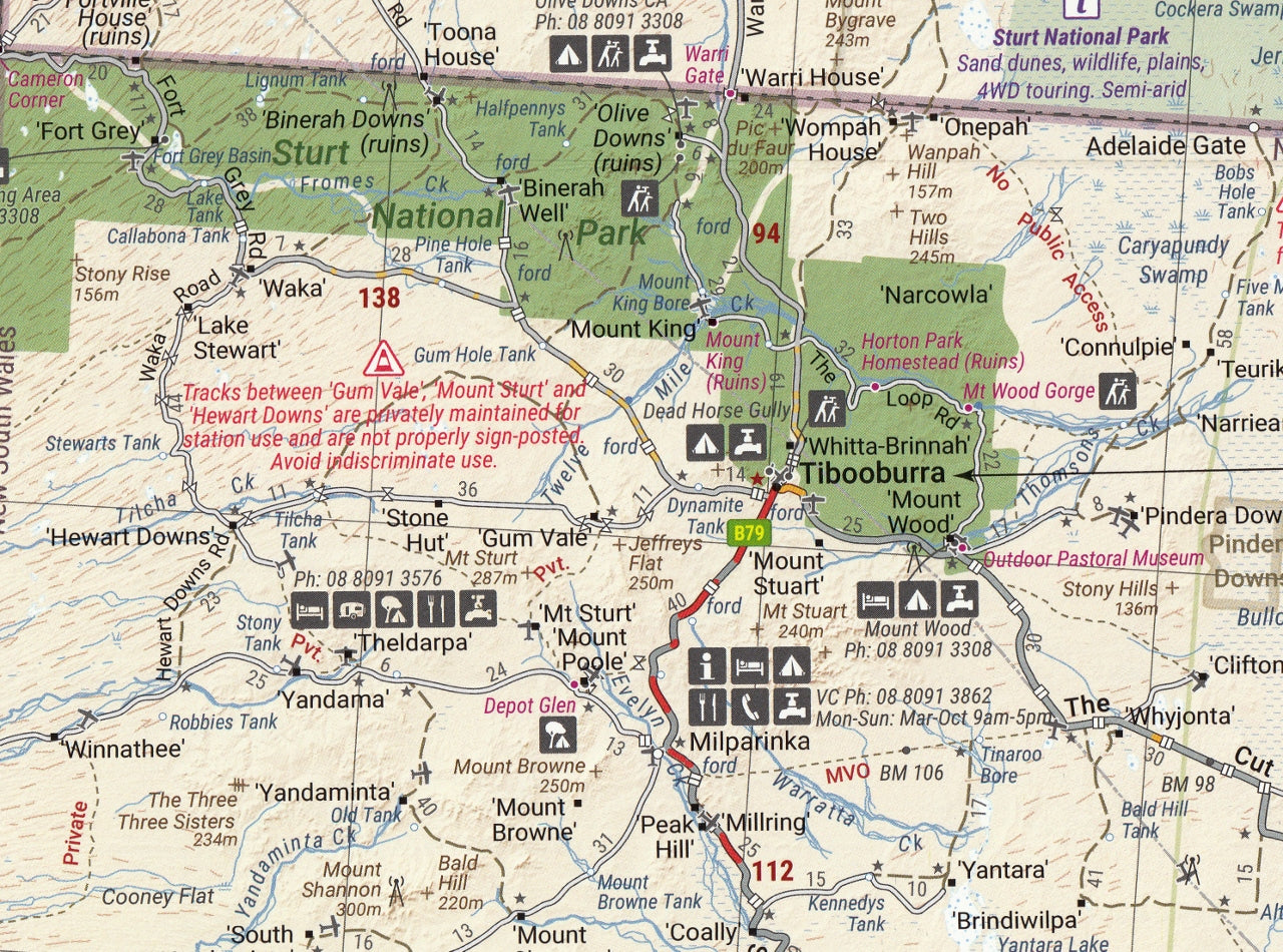
Great Desert Tracks Eastern Sheet Hema Map
$14.95
Afterpay is only available for orders between $50.00 and $1000.00 More info
Explore Australia’s Remote Outback with Confidence
📍 Available in Waterproof or Optional Laminated Format
🌄 Your Essential Map for Navigating the Eastern Deserts of Australia
The Eastern Sheet of the renowned Great Desert Tracks series by Hema Maps is the ultimate field-tested guide for anyone venturing into Australia’s remote eastern deserts. Whether you’re a seasoned 4WD adventurer, a grey nomad chasing horizon lines, or a wilderness explorer seeking out the most iconic desert routes, this map is your trusted companion into the wild heart of the outback.
Fully updated and now part of the streamlined three-map GDT series (Western, Central, Eastern), this edition combines both northern and southern regions of the eastern outback on one powerful and rugged navigation tool.
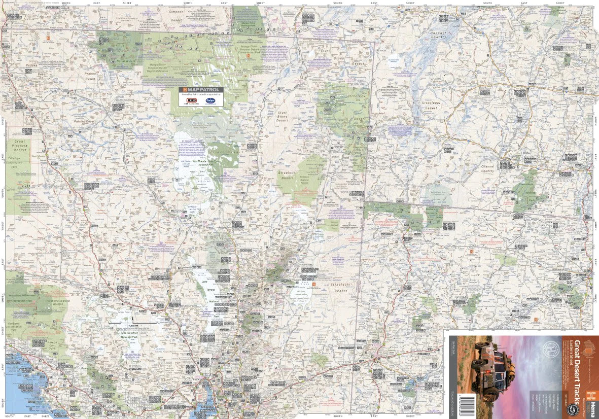
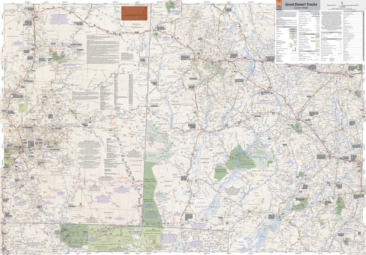
🗺️ Map Coverage – Eastern Arid Heart of Australia
Spanning a vast swathe of the continent, the Eastern Sheet covers:
-
North to South: from Boodjamulla National Park (QLD) to Port Augusta (SA)
-
East to West: from Cunamulla (QLD) to Alice Springs (NT)
This map encompasses some of the most legendary and remote desert tracks and regions:
-
🛻 Strzelecki Track
-
🛻 Birdsville Track
-
🛻 Oodnadatta Track
-
🛻 Corner Country
-
🛻 Plenty Highway
-
🛻 Sandover Highway
-
🛻 Lake Eyre Basin
-
🛻 Channel Country
-
🛻 Hay River Track
-
🛻 Simpson Desert (Eastern edge)
Whether you're planning a Simpson Desert crossing, tracing the footsteps of early explorers, or just want to lose the blacktop in favour of red dirt, this map has your route covered.
🧭 Key Features
| Feature | Details |
|---|---|
| Scale | 1:1,250,000 – ideal for remote desert route planning |
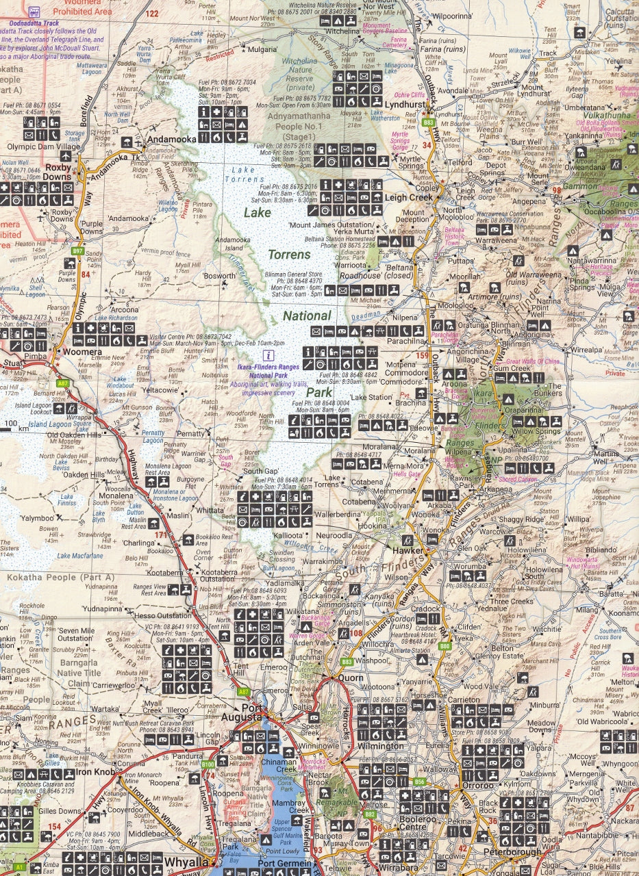
| Topographic Relief | Elevation shading helps visualise dunes, plains, and ranges |
| 4WD Tracks | GPS-surveyed and colour-coded by condition |
| Camping & Accommodation | Outback campsites, national park facilities, roadhouses |
| Fuel Availability | Marked petrol/diesel stations with 24-hour access noted |
| Permit Requirements | Clearly marked areas with relevant contact details |
| Water Points & Services | Locations for restocking and survival essentials |
| Points of Interest | Historic sites, ruins, landmarks, and natural features |
📚 Bonus Information
On the reverse side, the map includes:
-
✅ Permit & contact details for access through Aboriginal lands and national parks
-
✅ Fuel and provision availability for remote stops
-
✅ Descriptions and references for must-see locations
-
✅ Emergency numbers and traveller tips
📏 Map Specifications
| Specification | Details |
|---|---|
| Edition | 9th Edition |
| Publication Date | June 2022 |
| Unfolded Size | 1000 mm × 700 mm |
| Format | Printed on waterproof, tear-resistant synthetic paper |
| ISBN | 9781865009445 |
| Weight | 55 grams |
🛠️ Optional Upgrade: Laminated Map Format
Prefer added durability? We offer a laminated version of this map, perfect for repeated handling, writing, and on-the-road use.
-
💧 Encapsulated in 80-micron gloss laminate (both sides)
-
🖊️ Dry-erasable – mark your journey with whiteboard markers
-
📌 Ideal for map dots or trip planning pins
-
🔁 Reusable & rugged – perfect for extended touring
Note: Laminated versions are created by flattening the original folded map, so light fold lines may still be visible under the laminate.
🚐 Ideal For:
-
🛻 4WD adventurers crossing the Simpson Desert or Channel Country
-
🚐 Grey nomads and caravanners exploring remote Queensland & SA
-
📸 Outback photographers, tourers, and desert campers
-
🧭 Off-road planners and expedition organisers
-
🏕️ Overlanders seeking lesser-known bush camps and track access
🗺️ Part of a Complete Series
Want full coverage of Australia’s desert interior? Pair this Eastern Sheet with:
-
Central Sheet – Tanami, Great Victoria Desert, Googs Track
-
Western Sheet – Gunbarrel, Canning Stock Route, Connie Sue
-
Simpson Desert Sheet – Detailed Simpson Desert navigation
-
Great Desert Tracks Pack – All four in a tough travel folder
🏕️ Summary
The Hema Great Desert Tracks – Eastern Sheet is more than a map—it’s a meticulously crafted tool for safe, informed, and unforgettable desert exploration. Trusted by expedition leaders, 4WD clubs, and adventurers across the country, it's the perfect blend of rugged design, expert data, and visual clarity.
📦 Grab your copy now—choose the waterproof standard version or the ultra-durable laminated edition—and start mapping your next great desert adventure.
Frequently Asked Questions
What does the Great Desert Tracks Eastern Sheet Hema Map cover?
The Great Desert Tracks Eastern Sheet Hema Map covers 4WD tracks, camping areas, and travel routes for the region described in the product title. Most 4WD and camping guides in Mapworld's range include GPS coordinates, distance information, difficulty ratings, and notes on fuel stops and emergency contact points.
Is the Great Desert Tracks Eastern Sheet Hema Map up to date?
Yes, this is the current edition. Mapworld stocks current editions from publishers including Hema Maps, Westprint, and others.
Is this product suitable for remote area travel?
Yes, 4WD maps and guides are designed for remote area navigation and trip planning. They include track conditions, fuel availability, camping spots, and safety information.
Does Mapworld ship the Great Desert Tracks Eastern Sheet Hema Map across Australia?
Yes, Mapworld ships Australia-wide. Standard shipping is a flat $7 rate, with free standard shipping on orders over $75. Express options are available at checkout. Most orders placed before 2pm AEST on weekdays are dispatched same day.
Related Items


© 2026 Mapworld. Website designed by Genie Media
X